
Berkas:DETAIL VIEW OF MODIFIED WARREN TRUSS WITH VERTICALS. - Union Station Viaduct, Spanning Gaspee, Francis, Promenade and Canal Streets, Providence, Providence County, RI HAER RI,4-PROV,179-12.tif

Ukuran pratayang JPG ini dari berkas TIF ini: 747 × 599 piksel Resolusi lainnya: 299 × 240 piksel | 598 × 480 piksel | 957 × 768 piksel | 1.277 × 1.024 piksel | 2.553 × 2.048 piksel | 4.864 × 3.902 piksel.
Ukuran asli (4.864 × 3.902 piksel, ukuran berkas: 18,1 MB, tipe MIME: image/tiff)
Ringkasan
| DETAIL VIEW OF MODIFIED WARREN TRUSS WITH VERTICALS. - Union Station Viaduct, Spanning Gaspee, Francis, Promenade and Canal Streets, Providence, Providence County, RI | ||||
|---|---|---|---|---|
| Judul |
DETAIL VIEW OF MODIFIED WARREN TRUSS WITH VERTICALS. - Union Station Viaduct, Spanning Gaspee, Francis, Promenade and Canal Streets, Providence, Providence County, RI |
|||
| Deskripsi |
AMTRAK; New York, New Haven, and Hartford Railroad; Gagel, Edward; Federal Railroad Administration; DeLeuw, Cather, Parsons, contractor; Clement, Dan, transmitter; Owens, William, photographer; Barrett, William E, photographer |
|||
| Depicted place | Rhode Island; Providence County; Providence | |||
| Tanggal | Documentation compiled after 1968 | |||
| Ukuran | 4 x 5 in. | |||
| Lokasi |
Library of Congress Prints and Photographs Division Washington, D.C. 20540 USA http://hdl.loc.gov/loc.pnp/pp.print |
|||
| Kode inventaris |
HAER RI,4-PROV,179-12 |
|||
| Tipe akuisisi |
|
|||
| Catatan |
|
|||
| Sumber | https://www.loc.gov/pictures/item/ri0360.photos.145777p | |||
| Izin (Menggunakan kembali berkas ini) |
|
|||

| Lokasi objek | | Lihat gambar ini dan gambar di sekitarnya di: OpenStreetMap |
|---|
Riwayat berkas
Klik pada tanggal/waktu untuk melihat berkas ini pada saat tersebut.
| Tanggal/Waktu | Miniatur | Dimensi | Pengguna | Komentar | |
|---|---|---|---|---|---|
| terkini | 1 Agustus 2014 21.15 | 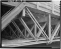 | 4.864 × 3.902 (18,1 MB) | Fæ | GWToolset: Creating mediafile for Fæ. HABS 31 July 2014 (3000:3200) |
Penggunaan berkas
Halaman berikut menggunakan berkas ini:
Penggunaan berkas global
Wiki lain berikut menggunakan berkas ini:
- Penggunaan pada en.wikipedia.org
- Penggunaan pada or.wikipedia.org