Ermelo: Perbedaan antara revisi
Konten dihapus Konten ditambahkan
k r2.7.2+) (bot Menambah: sq:Ermelo |
Courcelles (bicara | kontrib) k File renamed: File:Ermelo.svg → File:-Coat of arms of Ermelo.svg FR2; uninformative name |
||
| Baris 11: | Baris 11: | ||
| seal_size = |
| seal_size = |
||
| seal_alt = |
| seal_alt = |
||
| image_shield = Ermelo.svg |
| image_shield = -Coat of arms of Ermelo.svg |
||
| shield_size = 120x100px |
| shield_size = 120x100px |
||
| shield_alt = Coat of arms of Ermelo |
| shield_alt = Coat of arms of Ermelo |
||
Revisi per 23 Januari 2013 23.33
Ermelo | |
|---|---|
Municipality | |
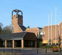
 Ermelo town hall | |
 | |
| Country | Netherlands |
| Province | Gelderland |
| Luas (2006) | |
| • Total | 87,38 km2 (3,374 sq mi) |
| • Luas daratan | 85,67 km2 (3,308 sq mi) |
| • Luas perairan | 1,72 km2 (66 sq mi) |
| Populasi (1 January, 2007) | |
| • Total | 26.297 |
| • Kepadatan | 307/km2 (800/sq mi) |
| Source: CBS, Statline. | |
| Zona waktu | UTC+1 (CET) |
| • Musim panas (DST) | UTC+2 (CEST) |
| Postal code | 3850 to 3853 |
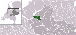
Ermelo, adalah sebuah gemeente Belanda yang terletak di provinsi Gelderland. Pada tahun 2004 daerah ini memiliki penduduk sebesar ... jiwa.


