Hrdibořice
Hrdibořice | |
|---|---|
Municipality | |
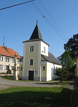
 Chapel of Saint Florian | |
| Koordinat: 49°28′50″N 17°13′20″E / 49.48056°N 17.22222°EKoordinat: 49°28′50″N 17°13′20″E / 49.48056°N 17.22222°E | |
| Country | |
| Region | Olomouc |
| District | Prostějov |
| Luas | |
| • Total | 3,79 km2 (146 sq mi) |
| Ketinggian | 214 m (702 ft) |
| Populasi (2006) | |
| • Total | 230 |
| • Kepadatan | 0,61/km2 (1,6/sq mi) |
| Postal code | 798 12 |
| Situs web | http://www.hrdiborice.cz |
Hrdibořice adalah sebuah desa dan kotamadya (obec) di Distrik Prostějov di Wilayah Olomouc, Republik Ceko.
Pranala luar[sunting | sunting sumber]
Wikimedia Commons memiliki media mengenai Hrdibořice.


