
Berkas:Nansen Fram Map.png
Tak tersedia resolusi yang lebih tinggi.
Nansen_Fram_Map.png (800 × 479 piksel, ukuran berkas: 195 KB, tipe MIME: image/png)
Ringkasan
| Deskripsi |
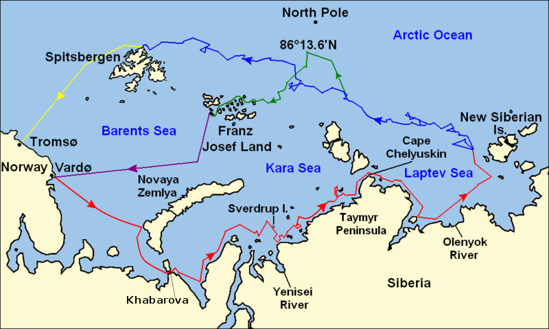
Map of the Arctic Ocean showing the routes taken during the 1893–96 Nansen's Fram expedition: Fram's route eastward from Vardø to the Siberian coast, turning north at the New Siberian Islands to enter the pack ice. July – September 1893 Fram's drift in the ice from the New Siberian Islands, north and west to Spitsbergen, September 1893 – August 1896 Nansen and Johansen's march to Farthest North, 86°20'N, and their subsequent retreat to Cape Flora in Franz Josef Land. February 1895 – June 1896 Nansen and Johansen's return to Vardø from Cape Flora, August 1896 Fram's voyage from Spitsbergen to Tromsø, August 1896 |
| Tanggal | |
| Sumber | Base map of European and Asian mainland is from File:Map of Russian Subjects old.png by User:fremantleboy, map of Spitsbergen (Svalbard) is based on File:Bjornoya map.png by User:NormanEinstein. Voyage traces based on this map from The Northern Lights Route. First published in Nansen, Fridtjof: Farthest North, Constable & Co, London 1897 |
| Pembuat | User:fremantleboy, User:NormanEinstein, Ruhrfisch |
| Izin (Menggunakan kembali berkas ini) |
GFDL, CC-BY-SA |
| Versi lainnya |
|


|
File:Nansen Fram Map.svg merupakan versi vektor dari berkas ini. Berkas itu harus digunakan menggantikan gambar raster ini jika kualitasnya tidak rendah.
File:Nansen Fram Map.png → File:Nansen Fram Map.svg
Untuk informasi lanjutan, lihat Bantuan:SVG. |
 |
Lisensi
Saya, pemilik hak cipta dari karya ini, dengan ini menerbitkan berkas ini di bawah ketentuan berikut:

|
Diizinkan untuk menyalin, mendistribusikan dan/atau memodifikasi dokumen ini di bawah syarat-syarat Lisensi Dokumentasi Bebas GNU, Versi 1.2 atau lebih baru yang diterbitkan oleh Free Software Foundation; tanpa Bagian Invarian, tanpa Teks Sampul Depan, dan tanpa Teks Sampul Belakang. Salinan lisensi dimasukkan ke bagian yang berjudul Lisensi Dokumentasi Bebas GNU. |
This file is licensed under the Creative Commons Attribution-Share Alike 4.0 International, 3.0 Unported, 2.5 Generic, 2.0 Generic and 1.0 Generic license.
- Anda diizinkan:
- untuk berbagi – untuk menyalin, mendistribusikan dan memindahkan karya ini
- untuk menggubah – untuk mengadaptasi karya ini
- Berdasarkan ketentuan berikut:
- atribusi – Anda harus mencantumkan atribusi yang sesuai, memberikan pranala ke lisensi, dan memberi tahu bila ada perubahan. Anda dapat melakukannya melalui cara yang Anda inginkan, namun tidak menyatakan bahwa pemberi lisensi mendukung Anda atau penggunaan Anda.
- berbagi serupa – Apabila Anda menggubah, mengubah, atau membuat turunan dari materi ini, Anda harus menyebarluaskan kontribusi Anda di bawah lisensi yang sama seperti lisensi pada materi asli.
Anda dapat memilih lisensi pilihan Anda.
Riwayat berkas
Klik pada tanggal/waktu untuk melihat berkas ini pada saat tersebut.
| Tanggal/Waktu | Miniatur | Dimensi | Pengguna | Komentar | |
|---|---|---|---|---|---|
| terkini | 8 Mei 2011 12.16 | | 800 × 479 (195 KB) | Chris55 | Added [http://website.lineone.net/~polar.publishing/khabarova.htm Khabarova] where they picked up the dogs. |
| 21 Oktober 2009 15.50 |  | 1.003 × 601 (78 KB) | Ruhrfisch | Make arrowheads less triangular (indentations at rear) | |
| 21 Oktober 2009 15.23 |  | 1.003 × 601 (78 KB) | Ruhrfisch | Add arrowheads per FAC | |
| 20 Oktober 2009 18.50 |  | 1.003 × 601 (78 KB) | Ruhrfisch | Make magenta line purple | |
| 11 Oktober 2009 13.36 |  | 1.003 × 601 (78 KB) | Ruhrfisch | Yellow line for orange, some labels smaller, Farthest North replaced with actual figure, all other info the same | |
| 11 Oktober 2009 03.08 |  | 1.003 × 601 (80 KB) | Ruhrfisch | Darker green for that line, all other information is the same | |
| 11 Oktober 2009 02.46 |  | 1.003 × 601 (80 KB) | Ruhrfisch | Added last two lines for ice voyages, added last labels, all other information the same. | |
| 9 Oktober 2009 19.30 |  | 1.003 × 601 (73 KB) | Ruhrfisch | Add labels, two more voyage lines, all other information is the same | |
| 9 Oktober 2009 16.12 |  | 1.003 × 601 (57 KB) | Ruhrfisch | == Summary == {{Information |Description = Map of the Arctic Ocean showing the path of Nansen's Fram expedition 1893 to 1896 |Source = Base map of European mainland is from [[:File:Map of Russian Subjects old.png] |
Penggunaan berkas
Halaman berikut menggunakan berkas ini:
Penggunaan berkas global
Wiki lain berikut menggunakan berkas ini:
- Penggunaan pada bg.wikipedia.org
- Penggunaan pada en.wikipedia.org
- Penggunaan pada es.wikipedia.org
- Penggunaan pada fr.wikipedia.org
- Penggunaan pada hr.wikipedia.org
- Penggunaan pada ja.wikipedia.org
- Penggunaan pada pt.wikipedia.org
- Penggunaan pada sl.wikipedia.org