
Berkas:Ukraine 2022-02-21.svg

Ukuran asli (Berkas SVG, secara nominal 1.546 × 1.038 piksel, besar berkas: 452 KB)
Ringkasan
| Deskripsi |
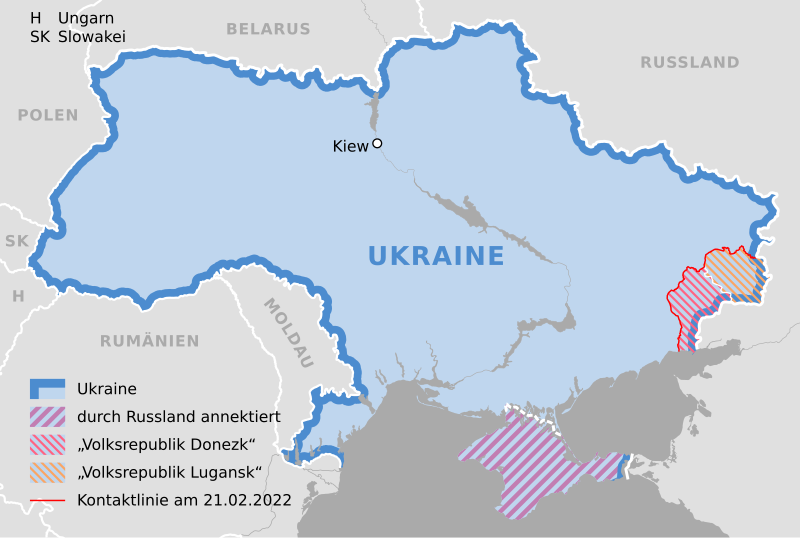
Deutsch: Karte der Ukraine, Stand 21. Februar 2022 |
||
| Tanggal | |||
| Sumber |
Own work using: Ukraine adm location map.svg by NordNordWest |
||
| Pembuat | NordNordWest | ||
| SVG genesis | Gambar vektor ini dibuat menggunakan Adobe Illustrator oleh NordNordWest
|

Lisensi
Usage of this file with:

explanatory notes: Legally binding is only the full legalcode. For a free usage I recommend to respect the following licence conditions:
1. Provide my name as given above: NordNordWest,
2. a copy of, or the URI for, the applicable license: https://creativecommons.org/licenses/by-sa/3.0/de/legalcode,
3. the title of the work,
4. in the case of an adaptation, a credit identifying the use of the work in the adaptation.
This license and the rights granted hereunder will terminate automatically upon any breach by you of the terms of this license. Any of the above conditions can be waived if you get permission from the copyright holder. If you have questions or wish differing conditions, please contact me through nnwest or my discussion page ![]() t-online.de
t-online.de
- Anda diizinkan:
- untuk berbagi – untuk menyalin, mendistribusikan dan memindahkan karya ini
- untuk menggubah – untuk mengadaptasi karya ini
- Berdasarkan ketentuan berikut:
- atribusi – Anda harus mencantumkan atribusi yang sesuai, memberikan pranala ke lisensi, dan memberi tahu bila ada perubahan. Anda dapat melakukannya melalui cara yang Anda inginkan, namun tidak menyatakan bahwa pemberi lisensi mendukung Anda atau penggunaan Anda.
- berbagi serupa – Apabila Anda menggubah, mengubah, atau membuat turunan dari materi ini, Anda harus menyebarluaskan kontribusi Anda di bawah lisensi yang sama seperti lisensi pada materi asli.

Riwayat berkas
Klik pada tanggal/waktu untuk melihat berkas ini pada saat tersebut.
| Tanggal/Waktu | Miniatur | Dimensi | Pengguna | Komentar | |
|---|---|---|---|---|---|
| terkini | 27 Februari 2022 15.34 | | 1.546 × 1.038 (452 KB) | NordNordWest | Reverted to version as of 14:40, 25 February 2022 (UTC); nein danke |
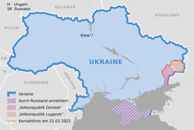
| 26 Februari 2022 20.31 |  | 1.546 × 1.038 (492 KB) | Kematen | Donezk weiter westlich | |
| 25 Februari 2022 19.51 |  | 1.546 × 1.038 (492 KB) | Kematen | übersichtlicher | |
| 25 Februari 2022 14.40 |  | 1.546 × 1.038 (452 KB) | NordNordWest | c | |
| 25 Februari 2022 14.38 |  | 1.546 × 1.038 (450 KB) | NordNordWest | c | |
| 24 Februari 2022 21.40 |  | 1.546 × 1.038 (442 KB) | NordNordWest | == {{int:filedesc}} == {{Information |description= {{de|1=Karte der Ukraine, Stand 21. Februar 2022}} |source={{Own using|Ukraine adm location map.svg|by=NordNordWest}} * https://www.osce.org/files/b/c/map_settlements--2022-02-20.jpg?itok=82567= |date={{Date|2022|02|24}} |author={{U|NordNordWest}} |permission= |other_versions= }} {{Kartenwerkstatt}} == {{int:license-header}} == {{User:NordNordWest/LicenceMap}} Category:Maps of the Russo-Ukrainian war Category:SVG maps of Ukraine [[... |
Penggunaan berkas
Tidak ada halaman yang menggunakan berkas ini.
Penggunaan berkas global
Wiki lain berikut menggunakan berkas ini:
- Penggunaan pada als.wikipedia.org
- Penggunaan pada de.wikipedia.org
- Penggunaan pada en.wikipedia.org