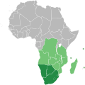
Berkas:Southern African Development Community.svg

Ukuran pratayang PNG ini dari berkas SVG ini: 600 × 600 piksel Resolusi lainnya: 240 × 240 piksel | 480 × 480 piksel | 768 × 768 piksel | 1.024 × 1.024 piksel | 2.048 × 2.048 piksel | 1.000 × 1.000 piksel.
Ukuran asli (Berkas SVG, secara nominal 1.000 × 1.000 piksel, besar berkas: 184 KB)
Riwayat berkas
Klik pada tanggal/waktu untuk melihat berkas ini pada saat tersebut.
| Tanggal/Waktu | Miniatur | Dimensi | Pengguna | Komentar | |
|---|---|---|---|---|---|
| terkini | 23 Juli 2018 10.34 |  | 1.000 × 1.000 (184 KB) | Ydecreux | Added Comoros |
| 21 November 2011 11.59 |  | 1.000 × 1.000 (184 KB) | Htonl | color scheme | |
| 20 November 2011 13.20 |  | 1.000 × 1.000 (184 KB) | Htonl | == {{int:filedesc}} == {{Information |Description=Map of Africa showing the member nations of the w:Southern African Development Community (SADC). Nations that are members of SADC and the w:Southern African Customs Union (SACU) are coloured dark |
Penggunaan berkas
Halaman berikut menggunakan berkas ini:
Penggunaan berkas global
Wiki lain berikut menggunakan berkas ini:
- Penggunaan pada af.wikipedia.org
- Penggunaan pada ar.wikipedia.org
- Penggunaan pada ast.wikipedia.org
- Penggunaan pada bg.wikipedia.org
- Penggunaan pada ca.wikipedia.org
- Penggunaan pada cs.wikipedia.org
- Penggunaan pada en.wikipedia.org
- Penggunaan pada es.wikipedia.org
- Penggunaan pada et.wikipedia.org
- Penggunaan pada eu.wikipedia.org
- Penggunaan pada fa.wikipedia.org
- Penggunaan pada fr.wikipedia.org
- Penggunaan pada hr.wikipedia.org
- Penggunaan pada ko.wikipedia.org
- Penggunaan pada mg.wikipedia.org
- Penggunaan pada pl.wikipedia.org
- Penggunaan pada pnb.wikipedia.org
- Penggunaan pada pt.wikipedia.org
- Penggunaan pada ru.wikipedia.org
- Penggunaan pada sr.wikipedia.org
- Penggunaan pada sw.wikipedia.org
- Penggunaan pada tn.wikipedia.org
- Penggunaan pada vi.wikipedia.org
- Penggunaan pada www.wikidata.org
- Penggunaan pada zh.wikipedia.org
