
Berkas:Shinkansen map 20110312 en.png
Ukuran pratayang ini: 581 × 600 piksel. Resolusi lainnya: 232 × 240 piksel | 465 × 480 piksel | 744 × 768 piksel | 992 × 1.024 piksel | 1.984 × 2.048 piksel | 3.100 × 3.200 piksel.
Ukuran asli (3.100 × 3.200 piksel, ukuran berkas: 370 KB, tipe MIME: image/png)
Ringkasan
| Deskripsi |
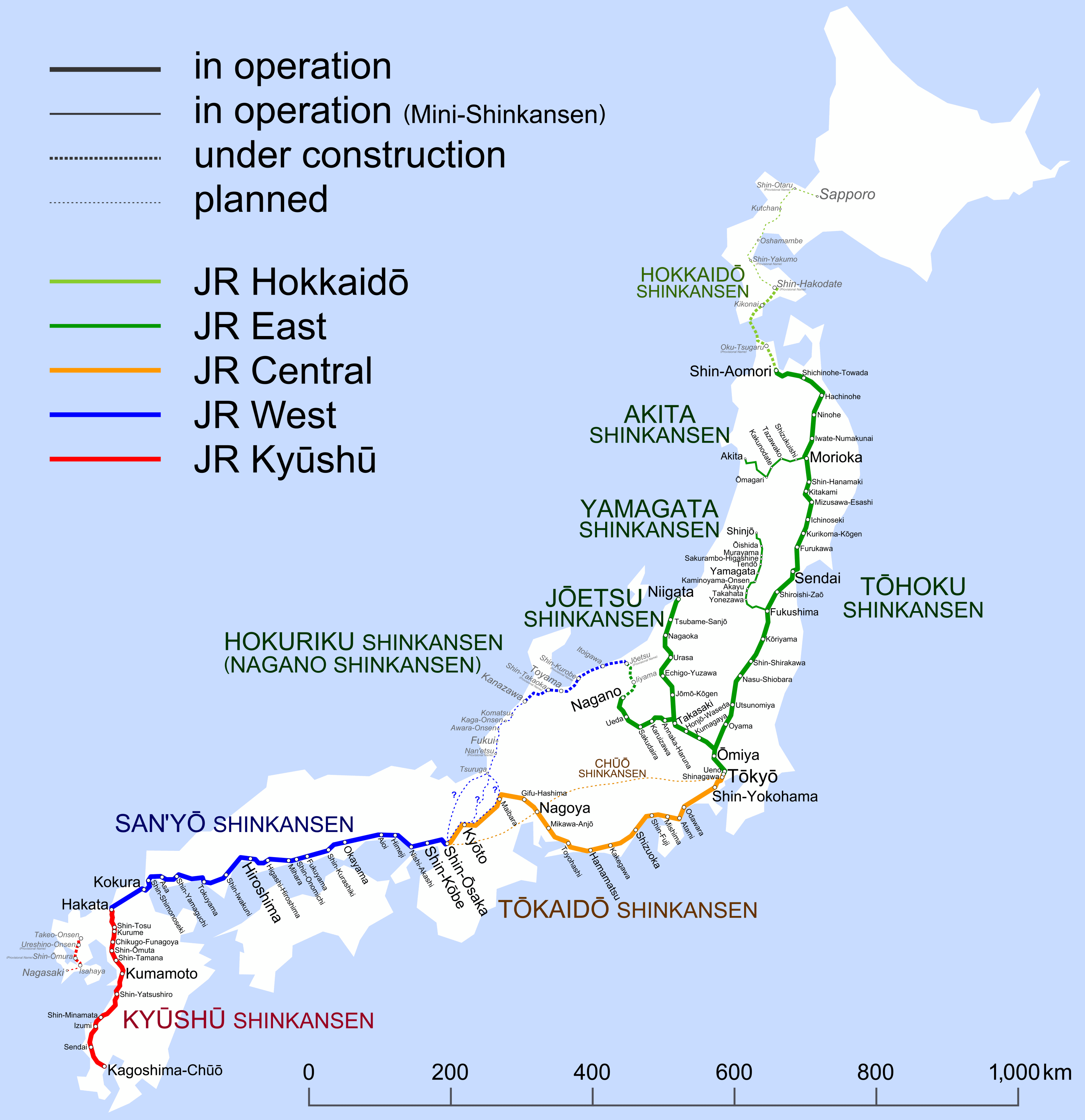
English: Map of Shinkansen network. (2011-03-12 – ) |
||||||||||||||||||||||||||||||||
| Tanggal | |||||||||||||||||||||||||||||||||
| Sumber | Karya sendiri | ||||||||||||||||||||||||||||||||
| Pembuat | Hisagi (氷鷺) | ||||||||||||||||||||||||||||||||
| Versi lainnya |
|
Lisensi
Saya, pemilik hak cipta dari karya ini, dengan ini menerbitkan berkas ini di bawah ketentuan berikut:
Berkas on ipartandoan sian on Creative Commons Attribution-Share Alike 3.0 Unported partadoan.
- Anda diizinkan:
- untuk berbagi – untuk menyalin, mendistribusikan dan memindahkan karya ini
- untuk menggubah – untuk mengadaptasi karya ini
- Berdasarkan ketentuan berikut:
- atribusi – Anda harus mencantumkan atribusi yang sesuai, memberikan pranala ke lisensi, dan memberi tahu bila ada perubahan. Anda dapat melakukannya melalui cara yang Anda inginkan, namun tidak menyatakan bahwa pemberi lisensi mendukung Anda atau penggunaan Anda.
- berbagi serupa – Apabila Anda menggubah, mengubah, atau membuat turunan dari materi ini, Anda harus menyebarluaskan kontribusi Anda di bawah lisensi yang sama seperti lisensi pada materi asli.

|
Diizinkan untuk menyalin, mendistribusikan dan/atau memodifikasi dokumen ini di bawah syarat-syarat Lisensi Dokumentasi Bebas GNU, Versi 1.2 atau lebih baru yang diterbitkan oleh Free Software Foundation; tanpa Bagian Invarian, tanpa Teks Sampul Depan, dan tanpa Teks Sampul Belakang. Salinan lisensi dimasukkan ke bagian yang berjudul Lisensi Dokumentasi Bebas GNU. |
Anda dapat memilih lisensi pilihan Anda.
Riwayat berkas
Klik pada tanggal/waktu untuk melihat berkas ini pada saat tersebut.
| Tanggal/Waktu | Miniatur | Dimensi | Pengguna | Komentar | |
|---|---|---|---|---|---|
| terkini | 27 Februari 2012 17.06 | | 3.100 × 3.200 (370 KB) | Karl432 | Reverted to version as of 23:19, 7 March 2011. The "removal of distracting diacritics from English names" is erroneous, as this does not take into account that the file is used for articles in several other languages. Also, the names in the map are not... |
| 11 Desember 2011 01.51 |  | 3.100 × 3.200 (386 KB) | DAJF | Removal of distracting diacritics (macrons) from English names | |
| 7 Maret 2011 23.19 |  | 3.100 × 3.200 (370 KB) | Hisagi | Ōyama→Oyama | |
| 6 Maret 2011 02.27 |  | 3.100 × 3.200 (361 KB) | Hisagi | {{Information |Description ={{en|1=Map of Shinkansen network. (after March 12, 2011) }} |Source ={{own}} |Author =Hisagi (氷鷺) |Date =2011-03-05 |Permission = |other_versions = }} [ |
Penggunaan berkas
Tidak ada halaman yang menggunakan berkas ini.
Penggunaan berkas global
Wiki lain berikut menggunakan berkas ini:
- Penggunaan pada ru.wikipedia.org