
Berkas:River Nith estuary.jpg

Ukuran pratayang ini: 800 × 533 piksel. Resolusi lainnya: 320 × 213 piksel | 640 × 427 piksel | 1.024 × 683 piksel | 1.280 × 853 piksel | 2.560 × 1.707 piksel | 3.504 × 2.336 piksel.
Ukuran asli (3.504 × 2.336 piksel, ukuran berkas: 8,68 MB, tipe MIME: image/jpeg)
Ringkasan
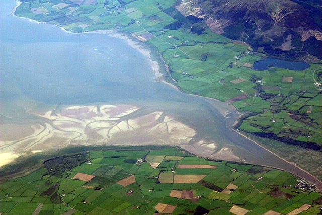
| Deskripsi | The estuary of the River Nith, Scotland, at low tide; opening into Solway Firth. This is a view of the Nith estuary from the north-east. The group of buildings at bottom right is the village of Glencaple. At bottom left near the wooded area is Caerlaverock Castle. At top right is Loch Kindar and the hill above is called Criffel. Just beyond the top left of photo is the birthplace of John Paul Jones. |
| Tanggal | |
| Sumber | https://www.flickr.com/photos/52614599@N00/483602946 |
| Pembuat | Doc Searls from Santa Barbara, USA |
Lisensi
Berkas ini dilisensikan di bawah lisensi Creative Commons Atribusi-Berbagi Serupa 2.0 Generik
- Anda diizinkan:
- untuk berbagi – untuk menyalin, mendistribusikan dan memindahkan karya ini
- untuk menggubah – untuk mengadaptasi karya ini
- Berdasarkan ketentuan berikut:
- atribusi – Anda harus mencantumkan atribusi yang sesuai, memberikan pranala ke lisensi, dan memberi tahu bila ada perubahan. Anda dapat melakukannya melalui cara yang Anda inginkan, namun tidak menyatakan bahwa pemberi lisensi mendukung Anda atau penggunaan Anda.
- berbagi serupa – Apabila Anda menggubah, mengubah, atau membuat turunan dari materi ini, Anda harus menyebarluaskan kontribusi Anda di bawah lisensi yang sama seperti lisensi pada materi asli.
| This image was originally posted to Flickr by dsearls at https://www.flickr.com/photos/52614599@N00/483602946. It was reviewed on 5 Mei 2007 by FlickreviewR and was confirmed to be licensed under the terms of the cc-by-sa-2.0. |
This is a view of the Nith estuary from the north-east. The group of buildings at bottom right is the village of Glencaple. At bottom left near the wooded area is Caerlaverock Castle. At top right is Loch Kindar and the hill above is called Criffel. Just beyond the top left of photo is the birthplace of John Paul Jones.
Riwayat berkas
Klik pada tanggal/waktu untuk melihat berkas ini pada saat tersebut.
| Tanggal/Waktu | Miniatur | Dimensi | Pengguna | Komentar | |
|---|---|---|---|---|---|
| terkini | 5 Mei 2007 07.14 | | 3.504 × 2.336 (8,68 MB) | Sandstein | {{Information |Description= The estuary of the River Nith, Scotland, at low tide; opening into Solway Firth. On the near shore, Bowness-on-Solway. On the far, Annan, in Dumfries and Galloway. |Source= http://www.flickr.com/photos/52614599@N00/483602946 |D |
Penggunaan berkas
Halaman berikut menggunakan berkas ini:
Penggunaan berkas global
Wiki lain berikut menggunakan berkas ini:
- Penggunaan pada ar.wikipedia.org
- Penggunaan pada arz.wikipedia.org
- Penggunaan pada ast.wikipedia.org
- Penggunaan pada bn.wikipedia.org
- Penggunaan pada br.wikipedia.org
- Penggunaan pada ceb.wikipedia.org
- Penggunaan pada cs.wikipedia.org
- Penggunaan pada cy.wikipedia.org
- Penggunaan pada dag.wikipedia.org
- Penggunaan pada de.wikipedia.org
- Penggunaan pada en.wikipedia.org
- Penggunaan pada en.wikivoyage.org
- Penggunaan pada eo.wikipedia.org
- Penggunaan pada es.wikipedia.org
- Penggunaan pada eu.wikipedia.org
- Penggunaan pada fa.wikipedia.org
- Penggunaan pada fr.wikipedia.org
- Penggunaan pada fy.wikipedia.org
- Penggunaan pada ga.wikipedia.org
- Penggunaan pada gd.wikipedia.org
- Penggunaan pada gv.wikipedia.org
- Penggunaan pada hak.wikipedia.org
- Penggunaan pada incubator.wikimedia.org
- Penggunaan pada it.wikipedia.org
- Penggunaan pada it.wikibooks.org
- Penggunaan pada it.wikiversity.org
- Penggunaan pada ja.wikipedia.org
- Penggunaan pada kbd.wikipedia.org
- Penggunaan pada lt.wikipedia.org
- Penggunaan pada nl.wikipedia.org
Lihat lebih banyak penggunaan global dari berkas ini.