
Berkas:NASA Radar 3-D View of San Andreas Fault.jpg
Ukuran pratayang ini: 654 × 600 piksel. Resolusi lainnya: 262 × 240 piksel | 523 × 480 piksel | 837 × 768 piksel | 1.116 × 1.024 piksel | 2.233 × 2.048 piksel | 2.984 × 2.737 piksel.
Ukuran asli (2.984 × 2.737 piksel, ukuran berkas: 7,6 MB, tipe MIME: image/jpeg)
Ringkasan
| Deskripsi |
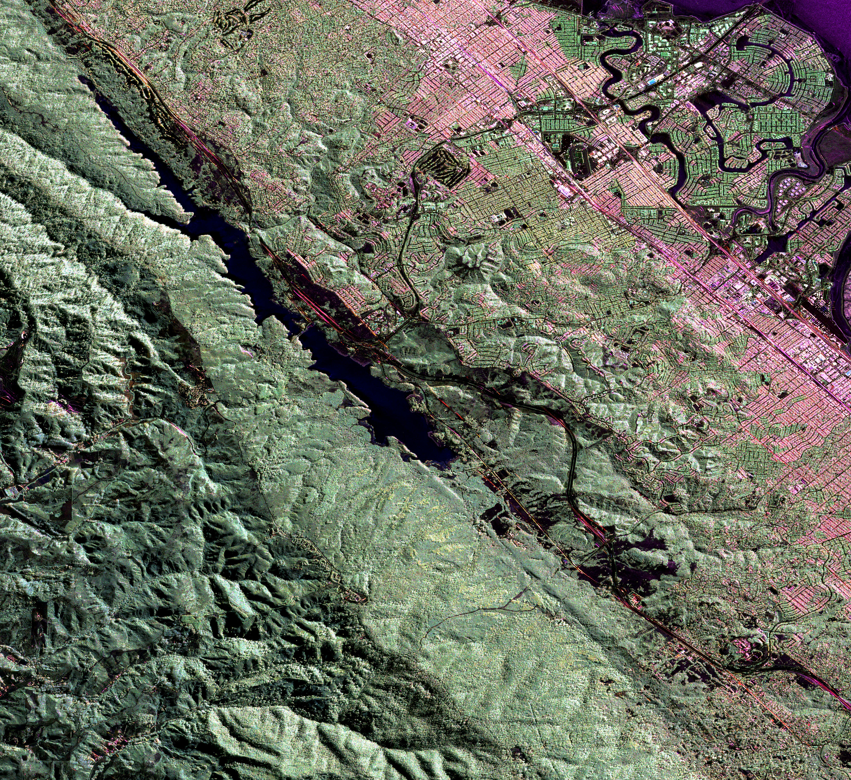
English: Much of the length of the San Andreas Fault is lined by a distinct trough. This false-colour radar image shows a section of the fault west of San Francisco Bay; the Crystal Springs Reservoir fills the trough that marks the underlying fault. The black line curving along the east side of the fault is I-280, and California highway 92 runs from the top right across to the centre left of the image, heading towards Half Moon Bay to the west. San Mateo and Burlingame are parts of the large urbanized area in various tones of pink and green, and Foster City is the area of curved streets extending out into the San Francisco Bay at the top right. |
| Tanggal | |
| Sumber | NASA Earth Observatory |
| Pembuat | Image courtesy of the NASA Jet Propulsion Laboratory. |
Instrument: Aircraft Sensors - UAVSARS
Lisensi
| Berkas ini berada dalam domain publik di Amerika Serikat karena semata-mata diciptakan oleh NASA. Kebijakan hak cipta NASA menyatakan bahwa "materi NASA tidak dilindungi oleh hak cipta kecuali dicatat". (Lihat Template:PD-USGov, Halaman kebijakan hak cipta NASA atau JPL Image Use Policy.) | ||
 |
Peringatan:
|
Riwayat berkas
Klik pada tanggal/waktu untuk melihat berkas ini pada saat tersebut.
| Tanggal/Waktu | Miniatur | Dimensi | Pengguna | Komentar | |
|---|---|---|---|---|---|
| terkini | 23 Juni 2009 09.27 | | 2.984 × 2.737 (7,6 MB) | Originalwana | {{Information |Description={{en|1=Much of the length of the San Andreas Fault is lined by a distinct trough. This false-colour radar image shows a section of the fault west of San Francisco Bay; the Crystal Springs Reservoir fills the trough that marks th |
Penggunaan berkas
Halaman berikut menggunakan berkas ini:
Penggunaan berkas global
Wiki lain berikut menggunakan berkas ini:
- Penggunaan pada en.wikipedia.org
- Penggunaan pada gl.wikipedia.org
- Penggunaan pada simple.wikipedia.org