
Berkas:Mingachevir Reservoir, Azerbaijan.JPG

Ukuran pratayang ini: 398 × 599 piksel. Resolusi lainnya: 159 × 240 piksel | 319 × 480 piksel | 510 × 768 piksel | 680 × 1.024 piksel | 1.361 × 2.048 piksel | 2.829 × 4.256 piksel.
Ukuran asli (2.829 × 4.256 piksel, ukuran berkas: 2,08 MB, tipe MIME: image/jpeg)
Ringkasan
| Deskripsi |
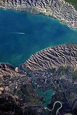
English: This detailed astronaut photograph highlights the southern Mingachevir Reservoir in north-central Azerbaijan. Folded layers of relatively young (less than 5. 3 million years old) sedimentary rock, explosive volcanic products (ash and tuff), and unconsolidated sediments form the grey hills along the northern and southern shorelines of the reservoir (image centre and right). Afternoon sun highlights distinctive parallel patterns in the hills that are the result of water and wind erosion of different rock layers exposed at the surface. The nearby city of Mingachevir (left) is split by the Kur River after it passes through the dam and hydroelectric power station complex at image top centre. The reservoir held approximately 15 billion cubic meters of water at the time this image was taken, with a total engineered capacity of 16 billion cubic meters. The width of the reservoir illustrated here is approximately 8 kilometres; a jet flying over the reservoir left a contrail midway between the shorelines. |
| Tanggal | |
| Sumber | NASA Earth Observatory |
| Pembuat | ISS Expedition 23 crew |
| Lokasi kamera | | Lihat gambar ini dan gambar di sekitarnya di: OpenStreetMap |
|---|
Gambar atau video ini telah dikatalogkan oleh Pusat Antariksa Johnson milik National Aeronautics and Space Administration (NASA)dibawah ID Foto: ISS023-E-35670. Label ini tidak menunjukkan status hak cipta dari berkas. Label hak cipta yang biasa tetap dibutuhkan. Lihat Commons:Lisensi. Bahasa lain:
|
Image captured with a Nikon D3S digital camera, and is provided by the ISS Crew Earth Observations experiment and Image Science & Analysis Laboratory, Johnson Space Center.
Lisensi
| Berkas ini berada dalam domain publik di Amerika Serikat karena semata-mata diciptakan oleh NASA. Kebijakan hak cipta NASA menyatakan bahwa "materi NASA tidak dilindungi oleh hak cipta kecuali dicatat". (Lihat Template:PD-USGov, Halaman kebijakan hak cipta NASA atau JPL Image Use Policy.) | ||
 |
Peringatan:
|
| Annotations | This image is annotated: View the annotations at Commons |
Riwayat berkas
Klik pada tanggal/waktu untuk melihat berkas ini pada saat tersebut.
| Tanggal/Waktu | Miniatur | Dimensi | Pengguna | Komentar | |
|---|---|---|---|---|---|
| terkini | 18 Juni 2018 10.00 | | 2.829 × 4.256 (2,08 MB) | SteinsplitterBot | Bot: Image rotated by 270° |
| 7 Juni 2010 16.54 |  | 4.256 × 2.829 (2,09 MB) | Originalwana | {{Information |Description={{en|1=This detailed astronaut photograph highlights the southern Mingachevir Reservoir in north-central Azerbaijan. Folded layers of relatively young (less than 5. 3 million years old) sedimentary rock, explosive volcanic p |
Penggunaan berkas
Halaman berikut menggunakan berkas ini:
Penggunaan berkas global
Wiki lain berikut menggunakan berkas ini:
- Penggunaan pada arz.wikipedia.org
- Penggunaan pada azb.wikipedia.org
- Penggunaan pada az.wikipedia.org
- Penggunaan pada az.wiktionary.org
- Penggunaan pada be.wikipedia.org
- Penggunaan pada ca.wikipedia.org
- Penggunaan pada ceb.wikipedia.org
- Penggunaan pada cs.wikipedia.org
- Penggunaan pada de.wikipedia.org
- Penggunaan pada en.wikipedia.org
- Penggunaan pada eo.wikipedia.org
- Penggunaan pada es.wikipedia.org
- Penggunaan pada fa.wikipedia.org
- Penggunaan pada fi.wikipedia.org
- Penggunaan pada fr.wikipedia.org
- Penggunaan pada fy.wikipedia.org
- Penggunaan pada he.wikipedia.org
- Penggunaan pada hr.wikipedia.org
- Penggunaan pada hu.wikipedia.org
- Penggunaan pada hy.wikipedia.org
- Penggunaan pada ilo.wikipedia.org
- Penggunaan pada it.wikipedia.org
- Penggunaan pada ja.wikipedia.org
Lihat lebih banyak penggunaan global dari berkas ini.