
Berkas:Manaus-Amazon-NASA.jpg
Ukuran pratayang ini: 600 × 600 piksel. Resolusi lainnya: 240 × 240 piksel | 480 × 480 piksel | 768 × 768 piksel | 1.024 × 1.024 piksel | 2.048 × 2.048 piksel | 5.312 × 5.312 piksel.
Ukuran asli (5.312 × 5.312 piksel, ukuran berkas: 8,7 MB, tipe MIME: image/jpeg)
Ringkasan
Descrption
Dipindahkan dari en.wikipedia ke Commons.
Halaman deskripsi aslinya ada di sini. Semua nama pengguna berikut merujuk pada en.wikipedia.
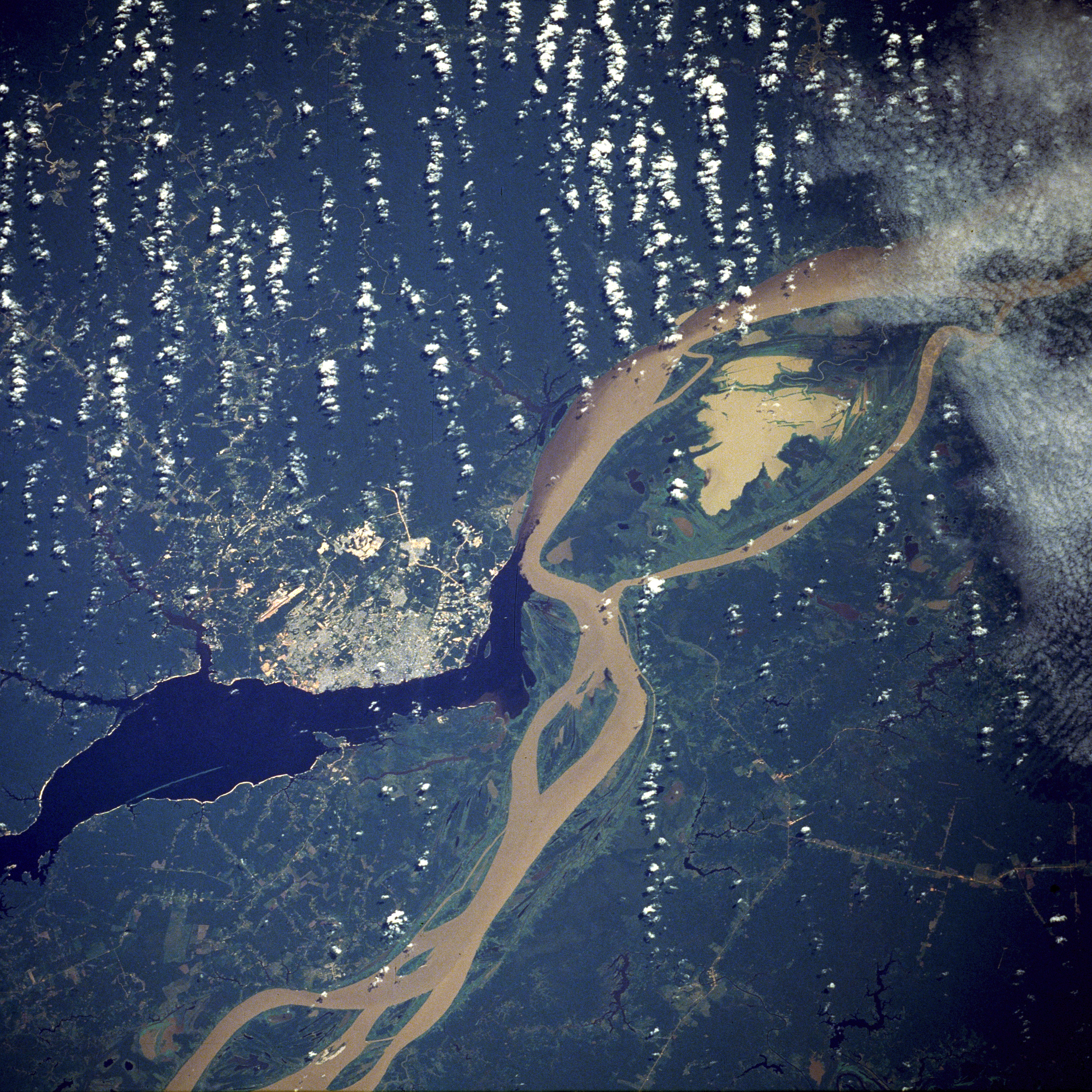
English: A satellite image of the city of Manaus with surrounding rivers.
English: Original caption:
- STS61C-33-84 Manaus, Amazonas, Brazil January 1986
- Two rivers and an urban area dominate this photograph. The largest city in the Amazon Basin, Manaus (with a 1994 population of 1.7 million), is located at the confluence of the Rio Negro (dark blue) and the Amazon River (lighter because of its high sediment content). The combined river flows eastward into the Atlantic Ocean. Situated approximately 800 miles (1290 kilometers) from the mouth of the Amazon River but accessible to oceangoing ships, Manaus is an important river port. This port city started to flourish in the late 1800s when the rubber boom was at its peak. Rubber, Brazil nuts, lumber, and assorted fruits are exported. In recent years, renewed interest in general development and the discovery of oil and manganese near Manaus have brought new importance to the city. A number of highways (linear, light-colored features), as well as a large commercial airport north of the city, are visible in the rain forest north and south of Manaus. North-south ground transportation is hindered because no bridges cross the Rio Negro or Amazon River. A large, sediment-laden lake (note irregular shoreline) is located east of Manaus between the main channel of the Amazon River and a smaller channel to the south.
Source
http://earth.jsc.nasa.gov/sseop/EFS/photoinfo.pl?PHOTO=STS61C-33-84 (file)
English: Photo credit: NASA
Gambar atau video ini telah dikatalogkan oleh salah satu pusat penelitian milik National Aeronautics and Space Administration (NASA)dibawah ID Foto: STS61C-33-84. Label ini tidak menunjukkan status hak cipta dari berkas. Label hak cipta yang biasa tetap dibutuhkan. Lihat Commons:Lisensi. Bahasa lain:
|
English-Wikipedia:
| date/time | username | edit summary |
|---|---|---|
| 10:52, 14 December 2004 | en:User:Magnus Manske | ({{PD-USGov-NASA}}) |
| 18:15, 18 June 2004 | en:User:Sverdrup | (Image info) |
| 18:14, 18 June 2004 | en:User:Sverdrup | (A satellite image of the city of <a href="/wiki/Manaus" title="Manaus">Manaus</a> with surrounding rivers.) |
Other version: Image:Manaus-Amazon-NASA2.jpg
See also

Lisensi
| Berkas ini berada dalam domain publik di Amerika Serikat karena semata-mata diciptakan oleh NASA. Kebijakan hak cipta NASA menyatakan bahwa "materi NASA tidak dilindungi oleh hak cipta kecuali dicatat". (Lihat Template:PD-USGov, Halaman kebijakan hak cipta NASA atau JPL Image Use Policy.) | ||
 |
Peringatan:
|
| Annotations | This image is annotated: View the annotations at Commons |
Riwayat berkas
Klik pada tanggal/waktu untuk melihat berkas ini pada saat tersebut.
| Tanggal/Waktu | Miniatur | Dimensi | Pengguna | Komentar | |
|---|---|---|---|---|---|
| terkini | 20 November 2011 05.17 | | 5.312 × 5.312 (8,7 MB) | Delirium | much higher-resolution version from the same source |
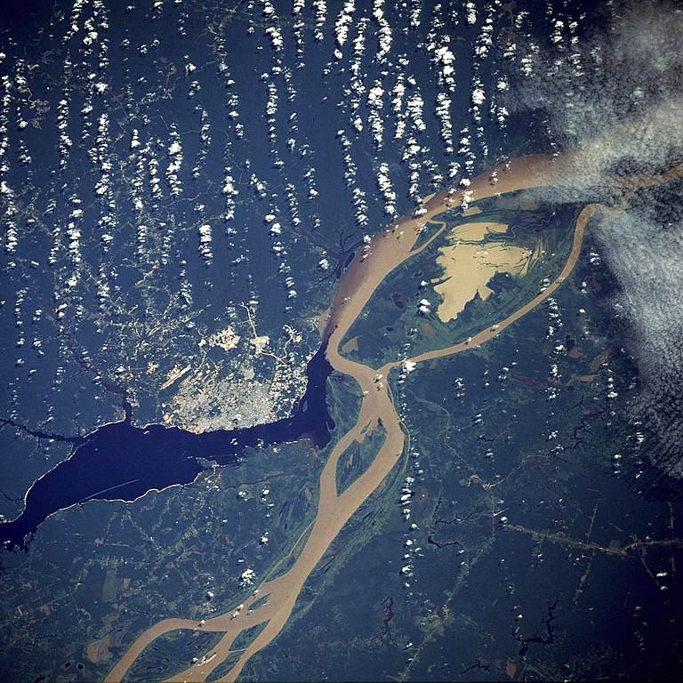
| 9 November 2011 04.38 |  | 640 × 640 (262 KB) | Creysmon07 | Corrected the contrast to a more realistic. | |
| 29 Januari 2006 14.41 |  | 640 × 640 (157 KB) | Maksim | La bildo estas kopiita de wikipedia:en. La originala priskribo estas: A satellite image of the city of Manaus with surrounding rivers. '''Original caption:''' :''STS61C-33-84 Manaus, Amazonas, Brazil January 1986'' :''Two rivers and an urban area d |
Penggunaan berkas
Halaman berikut menggunakan berkas ini:
Penggunaan berkas global
Wiki lain berikut menggunakan berkas ini:
- Penggunaan pada ar.wikipedia.org
- Penggunaan pada azb.wikipedia.org
- Penggunaan pada be.wikipedia.org
- Penggunaan pada bo.wikipedia.org
- Penggunaan pada ce.wikipedia.org
- Penggunaan pada cs.wikipedia.org
- Penggunaan pada de.wikipedia.org
- Penggunaan pada de.wikinews.org
- Penggunaan pada en.wikipedia.org
- Penggunaan pada en.wikinews.org
- Penggunaan pada eo.wikipedia.org
- Penggunaan pada et.wikipedia.org
- Penggunaan pada fa.wikipedia.org
- Penggunaan pada fi.wikipedia.org
- Penggunaan pada fr.wikipedia.org
- Penggunaan pada hr.wikipedia.org
- Penggunaan pada ja.wikipedia.org
- Penggunaan pada li.wikipedia.org
- Penggunaan pada ml.wikipedia.org
- Penggunaan pada nl.wikipedia.org
- Penggunaan pada no.wikipedia.org
- Penggunaan pada pt.wikipedia.org
- Penggunaan pada ro.wikipedia.org
- Penggunaan pada ru.wikipedia.org
- Penggunaan pada sv.wikipedia.org
- Penggunaan pada uk.wikipedia.org
- Penggunaan pada ur.wikipedia.org
- Penggunaan pada www.wikidata.org
- Penggunaan pada zh-yue.wikipedia.org
- Penggunaan pada zh.wikipedia.org