
Berkas:Le Castellet circuit map Formula One 2018 without corner names English 29 06 2021.svg

Ukuran pratayang PNG ini dari berkas SVG ini: 673 × 599 piksel Resolusi lainnya: 270 × 240 piksel | 539 × 480 piksel | 863 × 768 piksel | 1.150 × 1.024 piksel | 2.300 × 2.048 piksel | 2.191 × 1.951 piksel.
Ukuran asli (Berkas SVG, secara nominal 2.191 × 1.951 piksel, besar berkas: 59 KB)
Ringkasan
| Deskripsi |
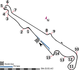
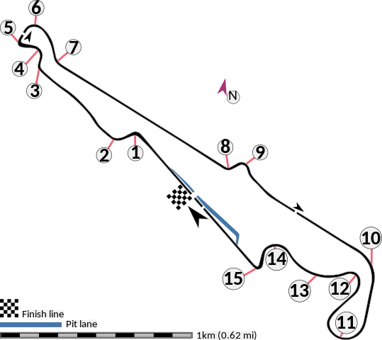
English: This is an altered version of File:Le Castellet circuit map Formula One 2018 without corner names June 2021.svg with the key solely in English and a few other alterations. This is a map of the Le Castellet motor circuit as it was used by w:en:Formula One for the w:en:2018 French Grand Prix, before the pit lane entrances and exits were reconfigured, and includes corner numbers and other information sourced from the FIA's map of the circuit. This map is valid for races which use this layout and corner numbering scheme, please upload a new file for races which use different layouts or corner numbering schemes rather than replacing this file. As this is a free-hand map drawn by an enthusiast rather than a professional cartographer's work it may contain some errors, although checking it against other maps it appears accurate enough for most purposes. The track is shown in black with a grey outline, while the pit lane is shown in blue. A scale showing the length of one kilometre (with increments of 100 metres) is given, to allow viewers to contextualise and understand what they are looking at. Corner numbers and other important text is given an off-white background to avoid transparency issues rendering it illegible on certain devices. A thick white line covering the track and the pit lane, marked with a chequered flag, shows the location of the start/finish line, also known as the control or timing line. A thinner white line, covering only the track, shows the location of pole position, and is marked with a large black arrow indicating the direction of travel. There are also thin white lines crossing the track which indicate the ends of the first and second timing sectors used by Formula One; these are marked with smaller black arrows, which also indicate the direction of travel. The mauve arrow marked "N" shows the direction of north.
Arrow pointing north Pit lane Links corner number to location of corner |
| Tanggal | |
| Sumber | Karya sendiri |
| Pembuat | HumanBodyPiloter5 |
| Versi lainnya |
   |
Lisensi
Saya, pemilik hak cipta dari karya ini, dengan ini menerbitkan berkas ini di bawah ketentuan berikut:
| Berkas ini dilepaskan di bawah CC0 1.0 Dedikasi Domain Publik Universal Creative Commons. | |
| Orang yang mengaitkan suatu karya dengan dokumen ini telah mendedikasikan karyanya sebagai domain publik dengan mengabaikan semua hak ciptanya di seluruh dunia menurut hukum hak cipta, termasuk semua hak yang terkait dan berhubungan, sejauh yang diakui hukum. Anda dapat menyalin, menyebarkan, dan mempertunjukkan karya, bahkan untuk tujuan komersial, tanpa meminta izin.
|
Riwayat berkas
Klik pada tanggal/waktu untuk melihat berkas ini pada saat tersebut.
| Tanggal/Waktu | Miniatur | Dimensi | Pengguna | Komentar | |
|---|---|---|---|---|---|
| terkini | 29 Juni 2021 01.15 | | 2.191 × 1.951 (59 KB) | HumanBodyPiloter5 | Uploaded own work with UploadWizard |
Penggunaan berkas
Halaman berikut menggunakan berkas ini:
Penggunaan berkas global
Wiki lain berikut menggunakan berkas ini:
- Penggunaan pada af.wikipedia.org
- Penggunaan pada en.wikipedia.org
- Penggunaan pada fi.wikipedia.org
- Penggunaan pada fr.wikipedia.org
- Penggunaan pada fy.wikipedia.org
- Penggunaan pada gl.wikipedia.org
- Penggunaan pada hr.wikipedia.org
- Penggunaan pada hu.wikipedia.org
- Penggunaan pada it.wikipedia.org
- Penggunaan pada pl.wikipedia.org
- Penggunaan pada ro.wikipedia.org
- Penggunaan pada tr.wikipedia.org