
Berkas:Kuala Lumpur at dawn (18794580599).jpg

Ukuran asli (7.360 × 4.912 piksel, ukuran berkas: 2,33 MB, tipe MIME: image/jpeg)
.jpg)
Ringkasan
| Deskripsi |
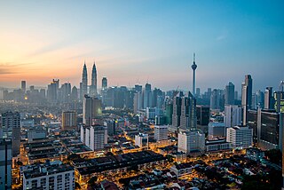
English: Kuala Lumpur is the national capital and most populous city in Malaysia. The city covers an area of 243 km2 and has an estimated population of 1.6 million as of 2010. Greater Kuala Lumpur, covering similar area as the Klang Valley, is an urban agglomeration of 7.5 million people as of 2012. It is among the fastest growing metropolitan regions in South-East Asia, in terms of population and economy.
Kuala Lumpur is the seat of the Parliament of Malaysia. The city was once home to the executive and judicial branches of the federal government, but they were moved to Putrajaya in early 1999. Some sections of the judiciary still remain in the capital city of Kuala Lumpur. The official residence of the Malaysian King, the Istana Negara, is also situated in Kuala Lumpur. Rated as an alpha world city, Kuala Lumpur is the cultural, financial and economic centre of Malaysia due to its position as the capital as well as being a key city. Kuala Lumpur was ranked 48th among global cities by Foreign Policy's 2010 Global Cities Index and was ranked 67th among global cities for economic and social innovation by the 2thinknow Innovation Cities Index in 2010. Since the 1990s, the city has played host to many international sporting, political and cultural events including the 1998 Commonwealth Games and the Formula One Grand Prix. In addition, Kuala Lumpur is home to the tallest twin buildings in the world, the Petronas Twin Towers, which have become an iconic symbol of Malaysia's futuristic development [Wikipedia.org] |
| Tanggal | |
| Sumber | Kuala Lumpur at dawn |
| Pembuat | Jorge Láscar from Melbourne, Australia |
| Lokasi kamera | | Lihat gambar ini dan gambar di sekitarnya di: OpenStreetMap |
|---|
.jpg¶ms=003.156242_N_0101.713056_E_globe:Earth_type:camera_source:Flickr_&language=id)
Lisensi
- Anda diizinkan:
- untuk berbagi – untuk menyalin, mendistribusikan dan memindahkan karya ini
- untuk menggubah – untuk mengadaptasi karya ini
- Berdasarkan ketentuan berikut:
- atribusi – Anda harus mencantumkan atribusi yang sesuai, memberikan pranala ke lisensi, dan memberi tahu bila ada perubahan. Anda dapat melakukannya melalui cara yang Anda inginkan, namun tidak menyatakan bahwa pemberi lisensi mendukung Anda atau penggunaan Anda.
| This image was originally posted to Flickr by Jorge Lascar at https://flickr.com/photos/8721758@N06/18794580599 (archive). It was reviewed on 2 Februari 2018 by FlickreviewR 2 and was confirmed to be licensed under the terms of the cc-by-2.0. |
Riwayat berkas
Klik pada tanggal/waktu untuk melihat berkas ini pada saat tersebut.
| Tanggal/Waktu | Miniatur | Dimensi | Pengguna | Komentar | |
|---|---|---|---|---|---|
| terkini | 2 Februari 2018 10.28 | | 7.360 × 4.912 (2,33 MB) | Thesupermat2 | Transferred from Flickr via Flickr2Commons |
Penggunaan berkas
Halaman berikut menggunakan berkas ini:
Penggunaan berkas global
Wiki lain berikut menggunakan berkas ini:
- Penggunaan pada bn.wikipedia.org
- Penggunaan pada bo.wikipedia.org
- Penggunaan pada en.wikipedia.org
- Kuala Lumpur
- Kajang
- Demographics of Malaysia
- Geography of Malaysia
- Shah Alam
- George Town, Penang
- List of cities in Malaysia
- Ipoh
- Kota Kinabalu
- Johor Bahru
- Klang (city)
- Kuantan
- Petaling Jaya
- Sungai Petani
- Alor Setar
- Subang Jaya
- Malacca City
- Tawau
- Portal:Malaysia
- Seberang Perai
- Iskandar Puteri
- Malaysia
- Lists of cities by country
- Ampang Jaya
- Portal:Malaysia/Topics
- Selayang
- Template:Largest cities of Malaysia
- Seremban
- User:Joothis
- List of megalopolises
- Penggunaan pada fr.wikipedia.org
- Penggunaan pada hu.wikipedia.org
- Penggunaan pada io.wikipedia.org
- Penggunaan pada ml.wikipedia.org
- Penggunaan pada no.wikipedia.org
- Penggunaan pada ta.wikipedia.org
- Penggunaan pada th.wikipedia.org
Lihat lebih banyak penggunaan global dari berkas ini.
.jpg)
.jpg)