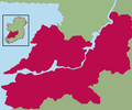
Berkas:Kingdom of Thomond.png
Tampilan

Ukuran pratayang ini: 800 × 462 piksel. Resolusi lainnya: 320 × 185 piksel | 640 × 369 piksel | 1.024 × 591 piksel | 1.655 × 955 piksel.
Ukuran asli (1.655 × 955 piksel, ukuran berkas: 137 KB, tipe MIME: image/png)
Riwayat berkas
Klik pada tanggal/waktu untuk melihat berkas ini pada saat tersebut.
| Tanggal/Waktu | Miniatur | Dimensi | Pengguna | Komentar | |
|---|---|---|---|---|---|
| terkini | 7 Desember 2021 18.24 |  | 1.655 × 955 (137 KB) | SKIBLY101 | much more realistic map... to the west are uí fidgenti, to the south the deisis and the east are o'carroll ely, why dont you give an actual source before challenging this instead of drawing arbitrary lines based on nothing |
| 20 Juni 2009 20.48 |  | 539 × 449 (30 KB) | Thomas Gun | colour | |
| 19 April 2009 06.24 |  | 539 × 449 (32 KB) | Thomas Gun | colour | |
| 29 Desember 2008 08.07 |  | 539 × 449 (36 KB) | Thomod | {{Information |Description= |Source= |Date= |Author= |Permission= |other_versions= }} | |
| 29 Desember 2008 08.04 |  | 539 × 449 (36 KB) | Thomod | {{Information |Description= |Source= |Date= |Author= |Permission= |other_versions= }} | |
| 29 Desember 2008 08.01 |  | 539 × 449 (36 KB) | Thomod | {{Information |Description= |Source= |Date= |Author= |Permission= |other_versions= }} | |
| 29 Desember 2008 07.54 |  | 539 × 449 (36 KB) | Thomod | {{Information |Description= |Source= |Date= |Author= |Permission= |other_versions= }} | |
| 26 Desember 2008 10.34 |  | 357 × 430 (37 KB) | Thomod | {{Information |Description= Rough map of the Kingdom of Thomond. Most sources describe it as in the area of the modern day Diocese of Killaloe, this is the boundaries which have been used |Source=myself |Date=26 December 2008 |Author=self-created |Permiss | |
| 26 Desember 2008 10.13 |  | 357 × 430 (38 KB) | Thomod | {{Information |Description= Rough map of the Kingdom of Thomond. Most sources describe it as in the area of the modern day Diocese of Killaloe, this is the boundaries which have been used |Source=myself |Date=26 December 2008 |Author=self-created |Permiss |
Penggunaan berkas
Halaman berikut menggunakan berkas ini:
Penggunaan berkas global
Wiki lain berikut menggunakan berkas ini:
- Penggunaan pada ca.wikipedia.org
- Penggunaan pada de.wikipedia.org
- Penggunaan pada en.wikipedia.org
- Penggunaan pada es.wikipedia.org
- Penggunaan pada eu.wikipedia.org
- Penggunaan pada fr.wikipedia.org
- Penggunaan pada ga.wikipedia.org
- Penggunaan pada it.wikipedia.org
- Penggunaan pada ko.wikipedia.org
- Penggunaan pada no.wikipedia.org
- Penggunaan pada ru.wikipedia.org
- Penggunaan pada uk.wikipedia.org
- Penggunaan pada www.wikidata.org
