
Berkas:Guam ali 2011364 lrg.jpg

Ukuran asli (3.994 × 5.148 piksel, ukuran berkas: 4,36 MB, tipe MIME: image/jpeg)
Ringkasan
| Deskripsi |
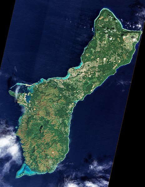
English: On December 30, 2011, cloud-free skies presented NASA’s Earth Observing-1 (EO-1) satellite with this unobstructed view of the island of Guam. Note that this image, taken by the satellite’s Advanced Land Imager (ALI), has been rotated and north is at right.
Located in the tropical Pacific Ocean, the U.S. territory of Guam lies at the southern end of the Mariana Island Chain. As the largest island in that archipelago, Guam stretches roughly 30 miles (50 kilometers) from northeast to southwest. Fields, forests, military bases, and settlements all mix on the landscape. Two prominent airstrips run northeast-southwest, one at the northeastern tip of the island, and the other in central Guam. Guam has two seasons: wet (June to December) and dry (January to June), and ALI acquired this image during the transition from wet to dry. The fate of that rainwater has a lot to do with whether it lands in the northern or southern part of the island. In southern Guam, volcanic rock predominates, but in northern Guam, limestone overlies volcanic rock. Limestone is porous—so porous, in fact, that practically all the water in northern Guam infiltrates the rock. After percolating through the limestone, water in northern Guam becomes part of the groundwater system. Guam’s rivers are confined to the southern part of the island, where less porous volcanic rock enables water to collect on the surface. Coral reefs fringe the island, and they are especially visible around Apra Harbor and Cocos Lagoon. Shallow water along these reefs glows peacock blue. Not far from Guam, the ocean is anything but shallow. Just east of the Mariana Islands lies the Mariana Trench. Located at the boundary between tectonic plates, it is the deepest point in the Earth’s ocean. References
NASA Earth Observatory image created by Jesse Allen and Robert Simmon, using EO-1 ALI data provided courtesy of the NASA EO-1 team and the United States Geological Survey. Caption by Michon Scott. Instrument: EO-1 - ALI |
| Tanggal | |
| Sumber | http://earthobservatory.nasa.gov/IOTD/view.php?id=77189 |
| Pembuat | NASA |
| Versi lainnya |
.jpg)
Lisensi
| Berkas ini berada dalam domain publik di Amerika Serikat karena semata-mata diciptakan oleh NASA. Kebijakan hak cipta NASA menyatakan bahwa "materi NASA tidak dilindungi oleh hak cipta kecuali dicatat". (Lihat Template:PD-USGov, Halaman kebijakan hak cipta NASA atau JPL Image Use Policy.) | ||
 |
Peringatan:
|
Riwayat berkas
Klik pada tanggal/waktu untuk melihat berkas ini pada saat tersebut.
| Tanggal/Waktu | Miniatur | Dimensi | Pengguna | Komentar | |
|---|---|---|---|---|---|
| terkini | 24 Mei 2020 08.16 | | 3.994 × 5.148 (4,36 MB) | Beyond My Ken | Adjs for visibility |
| 19 Februari 2012 22.53 |  | 4.014 × 6.021 (4,45 MB) | Melikamp |
Penggunaan berkas
2 halaman berikut menggunakan berkas ini:
Penggunaan berkas global
Wiki lain berikut menggunakan berkas ini:
- Penggunaan pada br.wikipedia.org
- Penggunaan pada bs.wikipedia.org
- Penggunaan pada en.wikipedia.org
- Penggunaan pada fo.wikipedia.org
- Penggunaan pada incubator.wikimedia.org
- Penggunaan pada ko.wikipedia.org
- Penggunaan pada ml.wikipedia.org
- Penggunaan pada nl.wikipedia.org
- Penggunaan pada pl.wikipedia.org
- Penggunaan pada tl.wikipedia.org
- Penggunaan pada tr.wikipedia.org
- Penggunaan pada zh-yue.wikipedia.org
- Penggunaan pada zh.wikipedia.org