
Berkas:Greece in 1210.svg

Ukuran pratayang PNG ini dari berkas SVG ini: 800 × 456 piksel Resolusi lainnya: 320 × 182 piksel | 640 × 365 piksel | 1.024 × 584 piksel | 1.280 × 730 piksel | 2.560 × 1.460 piksel | 3.508 × 2.000 piksel.
Ukuran asli (Berkas SVG, secara nominal 3.508 × 2.000 piksel, besar berkas: 1,12 MB)
Ringkasan
| Deskripsi |
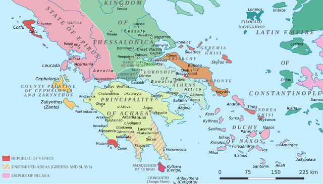
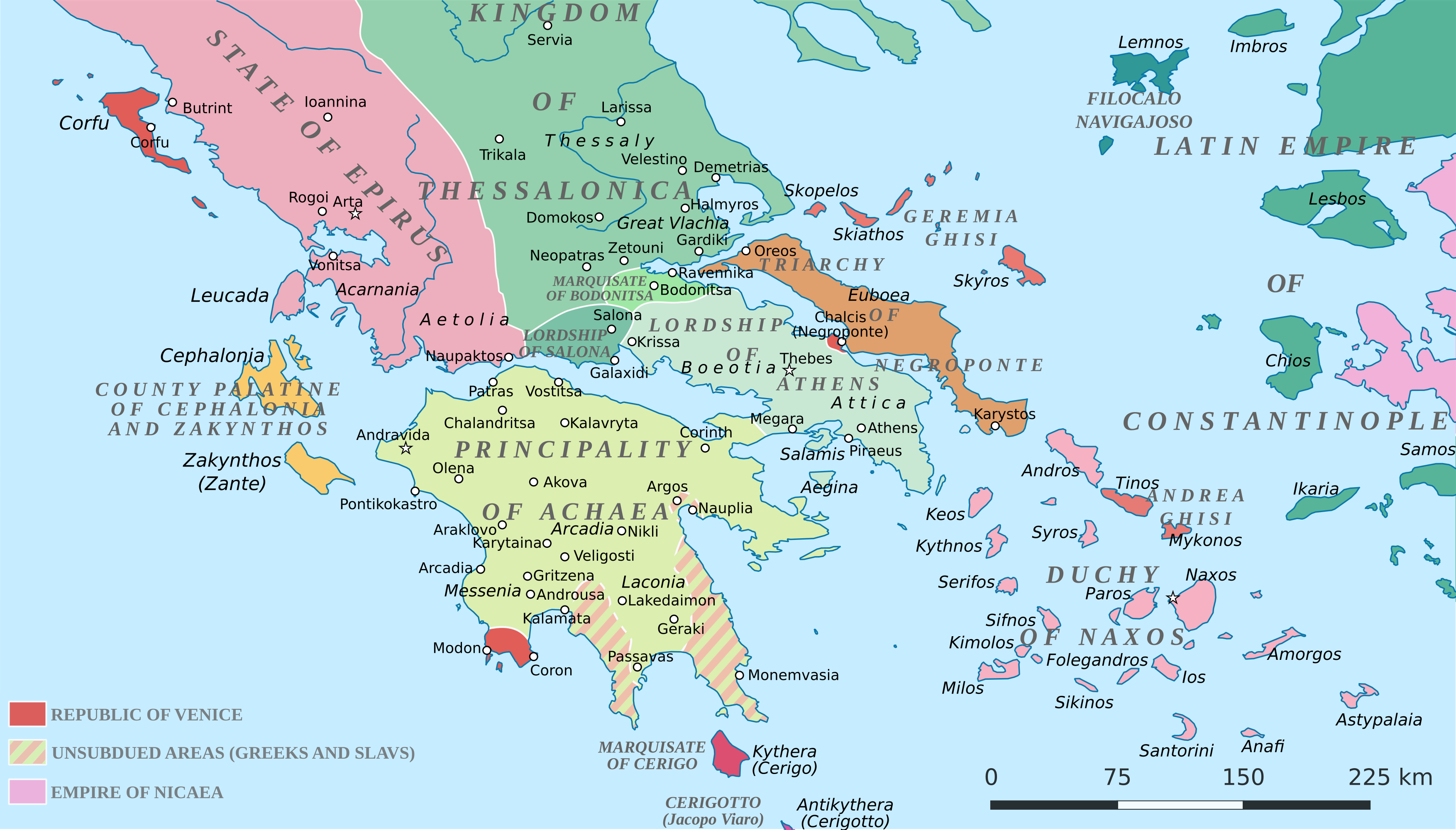
English: Political map of southern Greece in c. 1210, after the establishment of the Crusader states following the Fourth Crusade. |
| Tanggal | |
| Sumber |
SVG base from File:Greece in 1210V1.svg; based on the original political map by William Miller (1908), with changes and corrections to account for newer scholarship:
|
| Pembuat | Cplakidas |
| Versi lainnya |
|


Lisensi
Saya, pemilik hak cipta dari karya ini, dengan ini menerbitkan berkas ini di bawah ketentuan berikut:
Berkas ini dilisensikan di bawah lisensi Creative Commons Atribusi-Berbagi Serupa 4.0 Internasional.
- Anda diizinkan:
- untuk berbagi – untuk menyalin, mendistribusikan dan memindahkan karya ini
- untuk menggubah – untuk mengadaptasi karya ini
- Berdasarkan ketentuan berikut:
- atribusi – Anda harus mencantumkan atribusi yang sesuai, memberikan pranala ke lisensi, dan memberi tahu bila ada perubahan. Anda dapat melakukannya melalui cara yang Anda inginkan, namun tidak menyatakan bahwa pemberi lisensi mendukung Anda atau penggunaan Anda.
- berbagi serupa – Apabila Anda menggubah, mengubah, atau membuat turunan dari materi ini, Anda harus menyebarluaskan kontribusi Anda di bawah lisensi yang sama seperti lisensi pada materi asli.
Riwayat berkas
Klik pada tanggal/waktu untuk melihat berkas ini pada saat tersebut.
| Tanggal/Waktu | Miniatur | Dimensi | Pengguna | Komentar | |
|---|---|---|---|---|---|
| terkini | 23 Juni 2017 19.59 | | 3.508 × 2.000 (1,12 MB) | Cplakidas | fixed three names to paths |
| 11 April 2017 12.08 |  | 3.508 × 2.000 (1,1 MB) | Cplakidas | colour changes | |
| 11 April 2017 11.48 |  | 3.508 × 2.000 (1,11 MB) | Cplakidas | tweak around Coron | |
| 11 Februari 2017 10.39 |  | 3.508 × 2.000 (1,11 MB) | Cplakidas | tweaks in Negroponte, unsubdued areas | |
| 8 Februari 2017 17.57 |  | 3.508 × 2.000 (1,11 MB) | Cplakidas | tweaking the Morea | |
| 8 Februari 2017 13.40 |  | 3.508 × 2.000 (1,11 MB) | Cplakidas | slight tweaks | |
| 8 Februari 2017 13.14 |  | 3.508 × 2.000 (1,11 MB) | Cplakidas | User created page with UploadWizard |
Penggunaan berkas
Halaman berikut menggunakan berkas ini:
Penggunaan berkas global
Wiki lain berikut menggunakan berkas ini:
- Penggunaan pada ar.wikipedia.org
- Penggunaan pada az.wikipedia.org
- Penggunaan pada bg.wikipedia.org
- Penggunaan pada ca.wikipedia.org
- Penggunaan pada da.wikipedia.org
- Penggunaan pada de.wikipedia.org
- Penggunaan pada el.wikipedia.org
- Penggunaan pada en.wikipedia.org
- Penggunaan pada eo.wikipedia.org
- Penggunaan pada eu.wikipedia.org
- Penggunaan pada fa.wikipedia.org
- Penggunaan pada fr.wikipedia.org
- Penggunaan pada gl.wikipedia.org
- Penggunaan pada hr.wikipedia.org
- Penggunaan pada it.wikipedia.org
- Penggunaan pada ja.wikipedia.org
- Penggunaan pada ko.wikipedia.org
- Penggunaan pada ro.wikipedia.org
- Penggunaan pada ru.wikipedia.org
- Penggunaan pada sk.wikipedia.org
- Penggunaan pada sr.wikipedia.org
Lihat lebih banyak penggunaan global dari berkas ini.