
Berkas:Fires along the Rio Xingu, Brazil - NASA Earth Observatory.jpg

Ukuran asli (1.440 × 960 piksel, ukuran berkas: 329 KB, tipe MIME: image/jpeg)
Ringkasan
| Deskripsi |
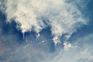
English: The rainforest of South America, also known as Amazonia, has been undergoing a continual and accelerated conversion process into farmlands (including pasture for livestock) since the early 1960s. This process has typically been achieved by clearing the forest using fire—“slash and burn”—followed by planting of crops. The generally infertile soils of this rainforest—the largest such forest on Earth—make sustainable farming difficult. This drives people to convert more forest into farmland. The area of clearing can be considerable, and since the deforested regions are easily identifiable and measurable from space, the rate of deforestation is likewise easy to track.
This astronaut photograph illustrates slash-and-burn forest clearing along the Rio Xingu (Xingu River) in the state of Matto Grasso, Brazil. The photo was taken from the International Space Station, a platform from which astronauts can capture images of the Earth from a variety of viewing angles. The perspective above shows both the horizontal position and the extent of the fire lines next to the river, while also providing a sense of the vertical structure of the smoke plumes. Light colored areas within the river channel are sand bars, which show that the river is in its annual low-flow/low-water stage. For a sense of scale, the river channel is approximately 63 kilometers (39 miles) long in this view. Rivers are the natural highways in Amazonia, which may explain why the burning is occurring right next to the Xingu River, one of Amazonia’s largest. In recent years, forest preservation has gained traction in the region as a result of new valuation of the ecosystem services provided by the forest, concerns about the impact of the burning on global climate change, and greater sensitivity to the ethnic and biological heritage of Amazonia. Astronaut photograph ISS029-E-8032 was acquired on September 17, 2011, with a Nikon D2Xs digital camera using a 200 mm lens, and is provided by the ISS Crew Earth Observations experiment and Image Science & Analysis Laboratory, Johnson Space Center. The image was taken by the Expedition 29 crew. The image has been cropped and enhanced to improve contrast. Lens artifacts have been removed. The International Space Station Program supports the laboratory as part of the ISS National Lab to help astronauts take pictures of Earth that will be of the greatest value to scientists and the public, and to make those images freely available on the Internet. Additional images taken by astronauts and cosmonauts can be viewed at the NASA/JSC Gateway to Astronaut Photography of Earth. Caption by William L. Stefanov, Jacobs/ESCG at NASA-JSC.
|
||||||||||||||||||||||||||||||||||||||||||||||||||
| Tanggal | |||||||||||||||||||||||||||||||||||||||||||||||||||
| Sumber | Fires along the Rio Xingu, Brazil | ||||||||||||||||||||||||||||||||||||||||||||||||||
| Pembuat | NASA's Earth Observatory | ||||||||||||||||||||||||||||||||||||||||||||||||||
| Versi lainnya |
|
||||||||||||||||||||||||||||||||||||||||||||||||||


| Lokasi kamera | | Lihat gambar ini dan gambar di sekitarnya di: OpenStreetMap |
|---|
Lisensi
- Anda diizinkan:
- untuk berbagi – untuk menyalin, mendistribusikan dan memindahkan karya ini
- untuk menggubah – untuk mengadaptasi karya ini
- Berdasarkan ketentuan berikut:
- atribusi – Anda harus mencantumkan atribusi yang sesuai, memberikan pranala ke lisensi, dan memberi tahu bila ada perubahan. Anda dapat melakukannya melalui cara yang Anda inginkan, namun tidak menyatakan bahwa pemberi lisensi mendukung Anda atau penggunaan Anda.
| This image was originally posted to Flickr by NASA Earth Observatory at https://www.flickr.com/photos/68824346@N02/6283416535. It was reviewed on 2 Juli 2012 by FlickreviewR and was confirmed to be licensed under the terms of the cc-by-2.0. |
This file is in the public domain in the United States because it was created by the Image Science & Analysis Laboratory, of the NASA Johnson Space Center. NASA copyright policy states that "NASA material is not protected by copyright unless noted". (NASA media use guidelines or Conditions of Use of Astronaut Photographs).
Photo source: ISS029-E-8032.
|
Riwayat berkas
Klik pada tanggal/waktu untuk melihat berkas ini pada saat tersebut.
| Tanggal/Waktu | Miniatur | Dimensi | Pengguna | Komentar | |
|---|---|---|---|---|---|
| terkini | 2 Juli 2012 17.22 | | 1.440 × 960 (329 KB) | Dzlinker | == {{int:filedesc}} == {{Information |Description=The rainforest of South America, also known as Amazonia, has been undergoing a continual and accelerated conversion process into farmlands (including pasture for livestock) since the early 1960s. This p... |
Penggunaan berkas
Halaman berikut menggunakan berkas ini:
Penggunaan berkas global
Wiki lain berikut menggunakan berkas ini:
- Penggunaan pada en.wikipedia.org
- Penggunaan pada it.wikipedia.org
- Penggunaan pada no.wikipedia.org
- Penggunaan pada vi.wikipedia.org