
Berkas:Europe, 1714.png
Ukuran pratayang ini: 800 × 546 piksel. Resolusi lainnya: 320 × 219 piksel | 640 × 437 piksel | 1.024 × 699 piksel | 1.280 × 874 piksel | 1.590 × 1.086 piksel.
Ukuran asli (1.590 × 1.086 piksel, ukuran berkas: 986 KB, tipe MIME: image/png)
_en.png)
.png)
.jpg)
Ringkasan
| Deskripsi |
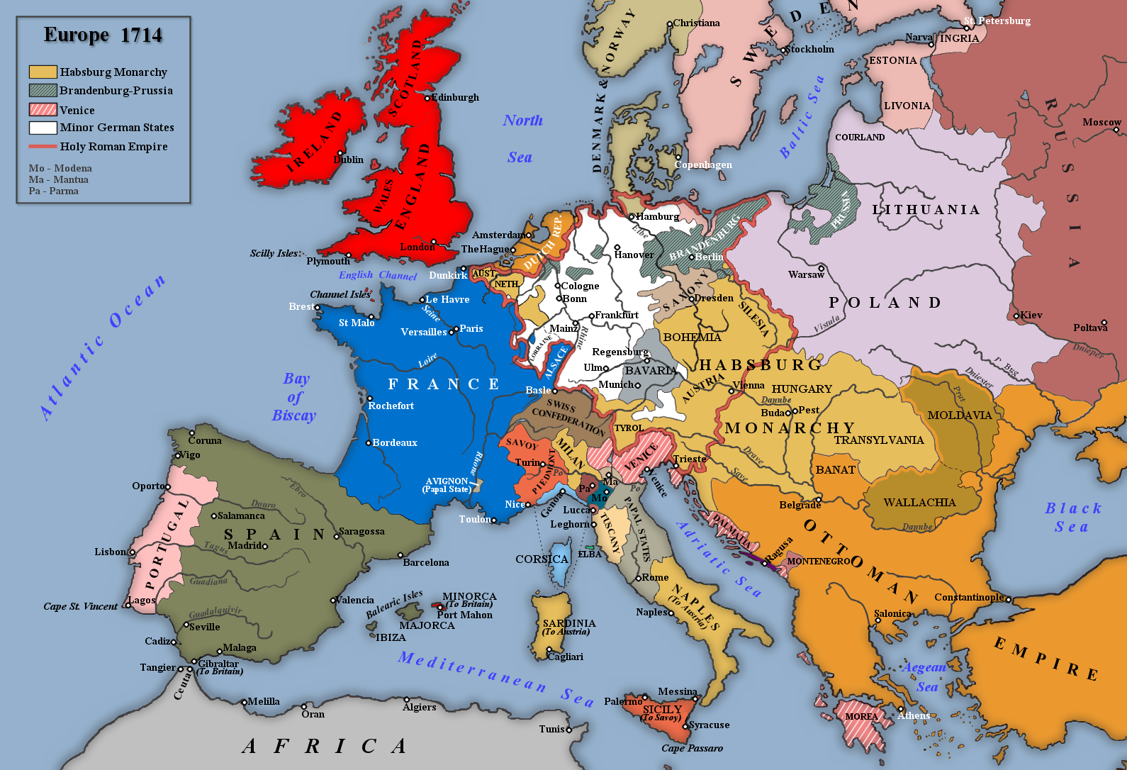
English: Map of Europe in 1714 |
| Tanggal | |
| Sumber | Karya sendiri |
| Pembuat | Rebel Redcoat |
Lisensi
| Saya, pemegang hak cipta karya ini, merilis karya ini ke domain umum. Lisensi ini berlaku di seluruh dunia. Di sejumlah negara, tindakan ini tidak memungkinkan secara sah; bila seperti itu: Saya memberikan siapa pun hak untuk menggunakan karya ini untuk tujuan apa pun, tanpa persyaratan apa pun, kecuali yang ditetapkan oleh hukum. |
Riwayat berkas
Klik pada tanggal/waktu untuk melihat berkas ini pada saat tersebut.
| Tanggal/Waktu | Miniatur | Dimensi | Pengguna | Komentar | |
|---|---|---|---|---|---|
| terkini | 2 Mei 2014 17.42 | | 1.590 × 1.086 (986 KB) | Spiridon Ion Cepleanu | According with H.E.Stier (dir.) Grosser Atlas zur Weltgeschichte, Westermann 1984, p.119, ISBN 3141009198, & all sources, the Danubian principalities were not turkish provinces but christian states (ruled by Greek hospodars), vassal of the Ottoman sult... |
| 7 Januari 2014 19.21 |  | 1.590 × 1.086 (1,07 MB) | Rebel Redcoat~commonswiki | Some minor improvements/accuracy | |
| 17 Januari 2013 11.59 |  | 1.590 × 1.086 (1,06 MB) | Rebel Redcoat~commonswiki | Added St. Petersburg | |
| 26 Mei 2012 15.00 |  | 1.590 × 1.086 (1,06 MB) | Rebel Redcoat~commonswiki | Correction: Sicily | |
| 6 Mei 2012 18.48 |  | 1.590 × 1.086 (1,06 MB) | Rebel Redcoat~commonswiki | Better quality | |
| 17 Juni 2010 23.30 |  | 1.594 × 1.090 (222 KB) | Rebel Redcoat~commonswiki | {{Information |Description={{en|1=Map of Europe in 1714}} |Source={{own}} |Author=Rebel Redcoat |Date=18 June 2010 |Permission= |other_versions= }} Category:Maps |
Penggunaan berkas
Halaman berikut menggunakan berkas ini:
Penggunaan berkas global
Wiki lain berikut menggunakan berkas ini:
- Penggunaan pada ar.wikipedia.org
- Penggunaan pada bg.wikipedia.org
- Penggunaan pada ca.wikipedia.org
- Penggunaan pada en.wikipedia.org
- Penggunaan pada fa.wikipedia.org
- Penggunaan pada fr.wikipedia.org
- Penggunaan pada gcr.wikipedia.org
- Penggunaan pada ja.wikipedia.org
- Penggunaan pada mk.wikipedia.org
- Penggunaan pada nl.wikipedia.org
- Penggunaan pada nn.wikipedia.org
- Penggunaan pada ru.wikipedia.org
- Penggunaan pada sh.wikipedia.org
- Penggunaan pada tr.wikipedia.org
- Penggunaan pada uk.wikipedia.org
- Penggunaan pada www.wikidata.org