
Berkas:Da-ming-hun-yi-tu.jpg

Ukuran pratayang ini: 683 × 600 piksel. Resolusi lainnya: 273 × 240 piksel | 547 × 480 piksel | 895 × 786 piksel.
Ukuran asli (895 × 786 piksel, ukuran berkas: 493 KB, tipe MIME: image/jpeg)
Ringkasan
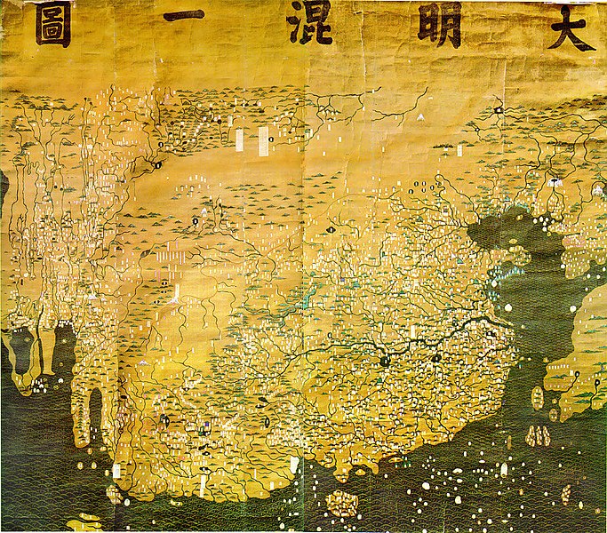
| Deskripsi | The Composite Map of the Ming Empire (Da Ming Hunyi Tu) reflects the political situation in AD 1389 but was likely painted much later. Original Chinese labels were later covered with Manchu on paper slips. |
| Tanggal | after 1389 |
| Sumber | http://geog.hkbu.edu.hk/GEOG1150/Chinese/Catalog/am31_map1.htm |
| Pembuat | Chinese (image enhanced by contributor) |
Lisensi
|
Ini adalah suatu perbanyakan fotografis dari sebuah karya seni dua dimensi. Karya seni tersebut berada pada domain publik karena alasan berikut:
Posisi resmi Wikimedia Foundation adalah bahwa "faithful reproductions of two-dimensional public domain works of art are public domain, and that claims to the contrary represent an assault on the very concept of a public domain". Untuk detilnya, lihat Commons:When to use the PD-Art tag.
Oleh karena itu, perbanyakan fotografis ini juga dianggap berada pada domain publik. Mohon diperhatikan bahwa hukum lokal mungkin saja melarang atau membatasi penggunaan kembali berkas ini di wilayah hukum anda. Lihat Commons:Reuse of PD-Art photographs. | ||||
Riwayat berkas
Klik pada tanggal/waktu untuk melihat berkas ini pada saat tersebut.
| Tanggal/Waktu | Miniatur | Dimensi | Pengguna | Komentar | |
|---|---|---|---|---|---|
| terkini | 17 Maret 2008 01.14 | | 895 × 786 (493 KB) | David Trochos | {{Information |Description=The Da Ming Hun Yi Tu (Great Ming Dynasty Amalagamated Map), painted on silk in AD 1389 but with Manchu language captions superimposed on paper slips several centuries later, is the oldest surviving Chinese world map. |Source= h |
| 16 Maret 2008 22.54 |  | 895 × 786 (487 KB) | David Trochos | {{Information |Description=The Da Ming Hun Yi Tu (Great Ming Dynasty Amalagamated Map), painted on silk in AD 1389 but with Manchu language captions superimposed on paper slips several centuries later, is the oldest surviving Chinese world map. |Source= h |
Penggunaan berkas
Halaman berikut menggunakan berkas ini:
Penggunaan berkas global
Wiki lain berikut menggunakan berkas ini:
- Penggunaan pada bn.wikipedia.org
- Penggunaan pada de.wikipedia.org
- Penggunaan pada en.wikipedia.org
- Penggunaan pada es.wikipedia.org
- Penggunaan pada fa.wikipedia.org
- Penggunaan pada fa.wikibooks.org
- Penggunaan pada fr.wikipedia.org
- Penggunaan pada hr.wikipedia.org
- Penggunaan pada it.wikipedia.org
- Penggunaan pada ja.wikipedia.org
- Penggunaan pada ko.wikipedia.org
- Penggunaan pada sl.wikipedia.org
- Penggunaan pada ur.wikipedia.org
- Penggunaan pada www.wikidata.org
- Penggunaan pada zh.wikipedia.org