
Berkas:Controlled airspaces.png

Ukuran pratayang ini: 800 × 291 piksel. Resolusi lainnya: 320 × 116 piksel | 640 × 233 piksel | 1.024 × 372 piksel | 1.280 × 465 piksel | 2.560 × 931 piksel | 10.826 × 3.937 piksel.
Ukuran asli (10.826 × 3.937 piksel, ukuran berkas: 1,57 MB, tipe MIME: image/png)
Ringkasan
| Deskripsi |
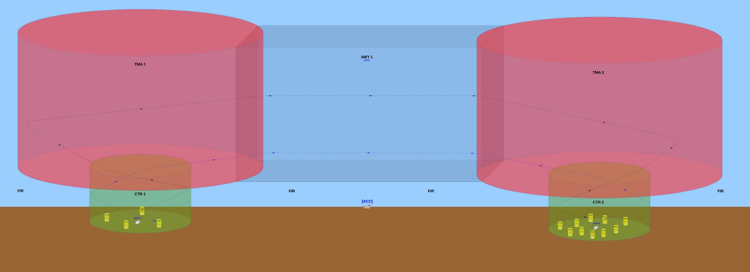
English: Basic configuration of the controlled airspaces and their respective air traffic control offices.
The TWR (aerodrome control tower) usually controls traffic that occurs inside the ATZ (aerodrome traffic zone) of the aerodrome where this TWR is installed at. The APP (approach control) usually controls traffic that occurs inside the CTR (control zone) but outside of the ATZs. The APP also controls traffic ocurring inside the TMA (terminal control area). The ACC (area control centre) usually controls traffic occurring inside any AWY (airway). In this image, the surrounding airspace (outside of the ATZs, CTRs, TMAs and AWY) is a non-controlled airspace designated a Flight Information Region (FIR). When an aircraft is flying into a FIR, no Air Traffic Control (ATC) office will provide any traffic control to this aircraft's pilot(s), however the ACC will provide it the Flight Information Service (FIS) and the Alerting Service (ALRS). Português: Configuração básica dos espaços aéreos controlados e seus respectivos órgãos de controle de tráfego aéreo.
A TWR (torre de controle de aeródromo) geralmente controla o tráfego que ocorre dentro da ATZ (Aerodrome Traffic Zone / Zona de Tráfego de Aeródromo) do aeródromo no qual essa TWR está instalada. O APP (Approach Control / Controle de Aproximação) geralmente controla o tráfego que ocorre dentro da CTR (Control Zone / Zona de Controle) mas que está fora das ATZ. O APP também controla o tráfego que ocorre dentro da TMA (Terminal Control Area / Área de Controle Terminal). O ACC (Area Control Centre / Centro de Controle de Área) geralmente controla o tráfego que ocorre dentro de qualquer AWY (Airway / Aerovia). Nesta imagem, o espaço aéreo ao redor (fora das ATZ, CTR, TMA e AWY) é um espaço aéreo não controlado denominado FIR (Flight Information Region / Região de Informação de Voo). Quando uma aeronave está voando dentro de uma FIR, nenhum órgão ATC (órgão de Air Traffic Control / Controle de Tráfego Aéreo) irá prover qualquer tipo de controle de tráfego para o(s) piloto(s) dessa aeronave, porém o ACC irá prover a esse(s) piloto(s) o FIS (Flight Information Service / Serviço de Informação de Voo) e o ALRS (Alerting Service / Serviço de Alerta). |
| Tanggal | |
| Sumber | Karya sendiri |
| Pembuat | Yuri Ribeiro Sucupira |
| Izin (Menggunakan kembali berkas ini) |
English: See license below. Attribution: when using this image, please provide a link to this page. As an alternative to providing a link, you can inform my full name (Yuri Ribeiro Sucupira) along with the license (see below). Português: Veja a licença abaixo. Atribuição: ao usar esta imagem, basta incluir uma ligação que aponte para esta página. Alternativamente, ao invés de fornecer um link você pode informar meu nome completo (Yuri Ribeiro Sucupira) juntamente com a licença (vide abaixo). |
| Versi lainnya |
English: The first version uploaded was quite different from the most up-to-date version and must not be used, mostly because it has a conceptual error: the inferior limit of the CTRs are above the Earth's surface, which is wrong because the inferior limit of a CTR must always be the Earth's surface. Português: A primeira versão incluída era consideravelmente diferente da versão mais atual deste desenho e não deve ser usada, principalmente porque essa primeira versão tem um erro conceitual: o limite inferior das duas CTR está acima do nível da superfície terrestre, mas isso está errado porque o limite inferior de uma CTR deve sempre ser a superfície terrestre. |
| Lokasi kamera | | Lihat gambar ini dan gambar di sekitarnya di: OpenStreetMap |
|---|
Lisensi
Saya, pemilik hak cipta dari karya ini, dengan ini menerbitkan berkas ini di bawah ketentuan berikut:
Berkas on ipartandoan sian on Creative Commons Attribution-Share Alike 3.0 Unported partadoan.
- Anda diizinkan:
- untuk berbagi – untuk menyalin, mendistribusikan dan memindahkan karya ini
- untuk menggubah – untuk mengadaptasi karya ini
- Berdasarkan ketentuan berikut:
- atribusi – Anda harus mencantumkan atribusi yang sesuai, memberikan pranala ke lisensi, dan memberi tahu bila ada perubahan. Anda dapat melakukannya melalui cara yang Anda inginkan, namun tidak menyatakan bahwa pemberi lisensi mendukung Anda atau penggunaan Anda.
- berbagi serupa – Apabila Anda menggubah, mengubah, atau membuat turunan dari materi ini, Anda harus menyebarluaskan kontribusi Anda di bawah lisensi yang sama seperti lisensi pada materi asli.
Riwayat berkas
Klik pada tanggal/waktu untuk melihat berkas ini pada saat tersebut.
| Tanggal/Waktu | Miniatur | Dimensi | Pengguna | Komentar | |
|---|---|---|---|---|---|
| terkini | 12 Maret 2014 21.39 | 10.826 × 3.937 (1,57 MB) | Sampayu | Improvement: added some objects (airplanes and towers) that were missing mostly on the right side of the picture. | |
| 11 Maret 2014 20.39 | 10.568 × 3.630 (1,27 MB) | Sampayu | This new version has more detailed visual informations and the file size is smaller, which makes it more didactic and is good to help Wikipedia articles and internet pages in general load faster when they have this image embedded in them. The previou... | ||
| 8 Maret 2014 09.15 | 3.550 × 1.185 (16,07 MB) | Sampayu | User created page with UploadWizard |
Penggunaan berkas
Halaman berikut menggunakan berkas ini:
Penggunaan berkas global
Wiki lain berikut menggunakan berkas ini:
- Penggunaan pada ar.wikipedia.org
- Penggunaan pada en.wikipedia.org
- Penggunaan pada fa.wikipedia.org
- Penggunaan pada pt.wikipedia.org