
Berkas:BNR (Ruthienie Blanche) Map 1918.jpg

Ukuran asli (4.400 × 3.015 piksel, ukuran berkas: 10,27 MB, tipe MIME: image/jpeg)
_Map_1918.jpg)
Ringkasan
| Judul |
Беларуская: Карта Беларускай Народнай Рэспублікі, 1918 Беларуская (тарашкевіца): Мапа Беларускай Народнай Рэспублікі, 1918
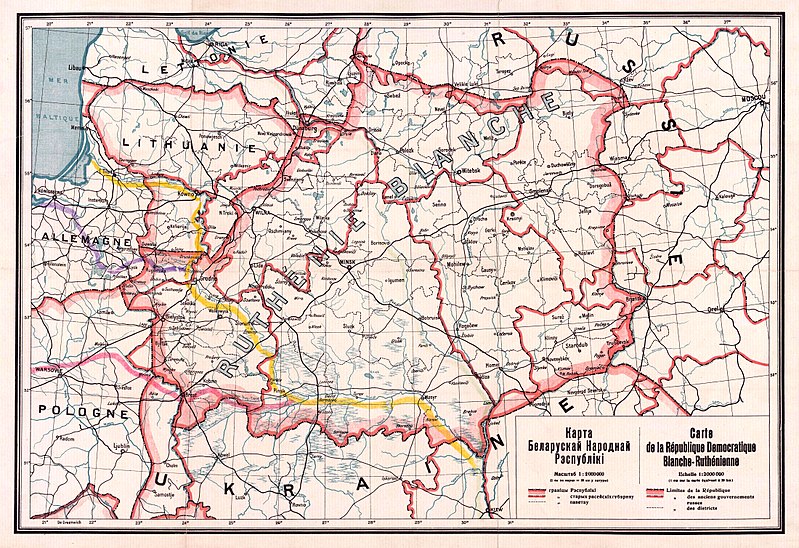
English: Map of the territory claimed by the Belarusian People's Republic (published in 1918).
Русский: Карта Белорусской Народной Республики, 1918
Українська: Карта Білоруської Народної Республіки, 1918 |
| Tanggal | |
| Sumber |
1. Карта БНР 1918 год, IMAGO.BY 2. Originally uploaded to English Wikipedia by Rydel (21:53, 2 January 2005) as en:Image:BNR ruthienie blanche.jpg. |
| Pencipta |
Tak diketahui |
| Georeferencing | If inappropriate please set warp_status = skip to hide. |
Lisensi
|
This work is in the public domain in its country of origin and other countries and areas where the copyright term is the author's life plus 70 years or fewer.
| |
| Berkas ini telah diidentifikasi bebas dari pembatasan menurut hukum hak cipta termasuk semua hak terkait dan relevan. | |
Riwayat berkas
Klik pada tanggal/waktu untuk melihat berkas ini pada saat tersebut.
| Tanggal/Waktu | Miniatur | Dimensi | Pengguna | Komentar | |
|---|---|---|---|---|---|
| terkini | 26 Oktober 2017 13.56 | | 4.400 × 3.015 (10,27 MB) | Kazimier Lachnovič | better quality |
| 3 September 2005 14.18 |  | 1.000 × 700 (195 KB) | EugeneZelenko | Map of Belarusian National Republic (published in 1918). Originally uploaded to English Wikipedia by Rydel (21:53, 2 January 2005) as en:Image:BNR ruthienie blanche.jpg. Category:Historical maps of Belarus |
Penggunaan berkas
Tidak ada halaman yang menggunakan berkas ini.
Penggunaan berkas global
Wiki lain berikut menggunakan berkas ini:
- Penggunaan pada ar.wikipedia.org
- Penggunaan pada ast.wikipedia.org
- Penggunaan pada be-tarask.wikipedia.org
- Penggunaan pada be.wikipedia.org
- Penggunaan pada bg.wikipedia.org
- Penggunaan pada ca.wikipedia.org
- Penggunaan pada cs.wikipedia.org
- Penggunaan pada cy.wikipedia.org
- Penggunaan pada da.wikipedia.org
- Penggunaan pada de.wikipedia.org
- Penggunaan pada en.wikipedia.org
- Penggunaan pada eo.wikipedia.org
- Penggunaan pada es.wikipedia.org
- Penggunaan pada et.wikipedia.org
- Penggunaan pada eu.wikipedia.org
- Penggunaan pada fr.wikipedia.org
Lihat lebih banyak penggunaan global dari berkas ini.
_Map_1918.jpg)
_Map_1918.jpg)