
Berkas:AgadezMNJattacks0807.png
AgadezMNJattacks0807.png (363 × 300 piksel, ukuran berkas: 105 KB, tipe MIME: image/png)
Ringkasan
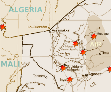
| Deskripsi | Map of the summer 2007 fighting between the tuareg insugenciey and government forces in the northwest of Niger | |||
| Tanggal | ||||
| Sumber |
Highly adapted using the Gimp from http://www.un.org/Depts/Cartographic/map/profile/niger.pdf
|
|||
| Pembuat | T L Miles |
Highly adapted from http://www.un.org/Depts/Cartographic/map/profile/niger.pdf
| This image is a map derived from a United Nations map.
Unless stated otherwise, UN maps are to be considered in the public domain. This applies worldwide. UN maps are, in principle, open source material and you can use them in your work or for making your own map. UN requests however that you delete the UN name, logo and reference number upon any modification to the map. Content of your map will be your responsibility. You can state in your publication, if you wish, something like: based on UN map … (map name, map number, revision number and date). See: Geospatial Information Section. And: Geospatial, location data for a better world. |
 |
Lisensi
| Saya, pemegang hak cipta karya ini, merilis karya ini ke domain umum. Lisensi ini berlaku di seluruh dunia. Di sejumlah negara, tindakan ini tidak memungkinkan secara sah; bila seperti itu: Saya memberikan siapa pun hak untuk menggunakan karya ini untuk tujuan apa pun, tanpa persyaratan apa pun, kecuali yang ditetapkan oleh hukum. |
Riwayat berkas
Klik pada tanggal/waktu untuk melihat berkas ini pada saat tersebut.
| Tanggal/Waktu | Miniatur | Dimensi | Pengguna | Komentar | |
|---|---|---|---|---|---|
| terkini | 30 Agustus 2007 19.13 | | 363 × 300 (105 KB) | T L Miles | {{Information |Description= Map of the summer 2007 fighting between the tuareg insugenciey and government forces in the northwest of Niger |Source=Highly adapted using the Gimp from http://www.un.org/Depts/Cartographic/map/profile/niger.pdf {{UN map}} |
Penggunaan berkas
Halaman berikut menggunakan berkas ini:
Penggunaan berkas global
Wiki lain berikut menggunakan berkas ini:
- Penggunaan pada de.wikipedia.org
- Penggunaan pada en.wikipedia.org
- Penggunaan pada es.wikipedia.org
- Penggunaan pada fi.wikipedia.org
- Penggunaan pada pt.wikipedia.org
- Penggunaan pada sv.wikipedia.org
- Penggunaan pada www.wikidata.org