
Berkas:60m artificial fumarole at el tatio geothermal field.jpg

Ukuran asli (900 × 595 piksel, ukuran berkas: 294 KB, tipe MIME: image/jpeg)
Ringkasan
| Deskripsi |
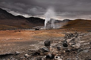
English: In 2008, the “Geortérmica del Norte” consortium - formed by Chilean state owned ENAP and Codelco mining companies in association with Italian Enel Green Power - began exploration in the "quebrada El Zoquete", near the El Tatio geothermal field in Chile's II Region, with the purpose of constructing a 40 MW geothermal plant. After months of exploration, an operating malfunction occurred in well No. 10 in September 2009, causing the eruption of a 60-m-high artificial fumarole which took away virtually all the pressure in the El Tatio complex. Although the company finally managed to close the well, damage was not limited to the visual. Ignorance of both guides and visitors - who were literally running all over the vents - caused extensive damage to the fragile mineral deposits, and the harm make take years, if not decades, to get undone. In fact, an earlier exploration attempt in the late sixties turned into disaster – even if only economically. |
| Tanggal | |
| Sumber | Karya sendiri |
| Pembuat | Gerard Prins |
| Lokasi kamera | | Lihat gambar ini dan gambar di sekitarnya di: OpenStreetMap |
|---|
Altitude: 4334.00 m
Lisensi
- Anda diizinkan:
- untuk berbagi – untuk menyalin, mendistribusikan dan memindahkan karya ini
- untuk menggubah – untuk mengadaptasi karya ini
- Berdasarkan ketentuan berikut:
- atribusi – Anda harus mencantumkan atribusi yang sesuai, memberikan pranala ke lisensi, dan memberi tahu bila ada perubahan. Anda dapat melakukannya melalui cara yang Anda inginkan, namun tidak menyatakan bahwa pemberi lisensi mendukung Anda atau penggunaan Anda.
- berbagi serupa – Apabila Anda menggubah, mengubah, atau membuat turunan dari materi ini, Anda harus menyebarluaskan kontribusi Anda di bawah lisensi yang sama seperti lisensi pada materi asli.

|
Diizinkan untuk menyalin, mendistribusikan dan/atau memodifikasi dokumen ini di bawah syarat-syarat Lisensi Dokumentasi Bebas GNU, Versi 1.2 atau lebih baru yang diterbitkan oleh Free Software Foundation; tanpa Bagian Invarian, tanpa Teks Sampul Depan, dan tanpa Teks Sampul Belakang. Salinan lisensi dimasukkan ke bagian yang berjudul Lisensi Dokumentasi Bebas GNU. |
Riwayat berkas
Klik pada tanggal/waktu untuk melihat berkas ini pada saat tersebut.
| Tanggal/Waktu | Miniatur | Dimensi | Pengguna | Komentar | |
|---|---|---|---|---|---|
| terkini | 23 Februari 2010 07.47 | | 900 × 595 (294 KB) | Gerard Prins | {{Information |Description={{en|1=A failed prospecting drill for geothermal exploitation by the “Geortérmica del Norte” consortium, formed by Chilean state owned ENAP and Codelco in association with Italian state owned ENEL, has caused an eco disaste |
Penggunaan berkas
Halaman berikut menggunakan berkas ini:
Penggunaan berkas global
Wiki lain berikut menggunakan berkas ini:
- Penggunaan pada ba.wikipedia.org
- Penggunaan pada en.wikipedia.org
- Penggunaan pada en.wikivoyage.org
- Penggunaan pada es.wikipedia.org
- Penggunaan pada hy.wikipedia.org
- Penggunaan pada kk.wikipedia.org
- Penggunaan pada ru.wikipedia.org
- Penggunaan pada uk.wikipedia.org