Al-Nabi Yusha'
Tampilan
Al-Nabi Yusha'
النبي يوشع | |
|---|---|
Village | |
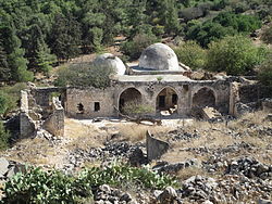
 Kuil Nebi Yusha pada 2013 | |
| Etimologi: "Nabi Yosua"[1] | |
| Koordinat: 33°06′46″N 35°33′22″E / 33.11278°N 35.55611°E | |
| Grid Palestina | 202/279 |
| Entitas geopolitik | Mandat Palestina |
| Subdistrik | Safad |
| Tanggal pengosongan | 16 Mei 1948[4] |
| Luas | |
| • Total | 3,617 dunams (3,617 km2 or 1,397 sq mi) |
| Populasi (1945) | |
| • Total | 70[2][3] |
| Sebab pengosongan | Serangan militer oleh pasukan Yishuv |
| Wilayah lain | Ramot Naftali |
Al-Nabi Yusha' (bahasa Arab: النبي يوشع adalah sebuah desa Palestina kecil di Galilea yang berjarak 17 kilometer dari timur laut Safad, dengan ketinggian 375 meter di atas permukaan laut. Desa tersebut menjadi bagian dari Mandat Palestina di bawah kekuasaan Inggris dari 1923 sampai 1948, saat desa tersebut dikosongkan pada Perang Arab-Israel 1948.
Referensi
[sunting | sunting sumber]- ^ Palmer, 1881, p.92
- ^ a b Government of Palestine, Department of Statistics. Village Statistics, April, 1945. Quoted in Hadawi, 1970, p. 70 Diarsipkan 2015-09-24 di Wayback Machine.
- ^ Government of Palestine, Department of Statistics, 1945, p. 10
- ^ Morris, 2004, p. xvi, village #26. Also gives cause of depopulation.
Daftar pustaka
[sunting | sunting sumber]- Berger, Uri (2015-12-09). "En-Nabi Yusha'" (127). Hadashot Arkheologiyot – Excavations and Surveys in Israel.
- Biger, Gideon (2004). The boundaries of modern Palestine, 1840-1947. Routledge. hlm. 134. ISBN 978-0-7146-5654-0.
- Conder, C.R.; Kitchener, H.H. (1881). The Survey of Western Palestine: Memoirs of the Topography, Orography, Hydrography, and Archaeology. 1. London: Committee of the Palestine Exploration Fund.
- Government of Palestine, Department of Statistics (1945). Village Statistics, April, 1945.
- Guérin, V. (1880). Description Géographique Historique et Archéologique de la Palestine (dalam bahasa French). 3: Galilee, pt. 2. Paris: L'Imprimerie Nationale.
- Hadawi, S. (1970). Village Statistics of 1945: A Classification of Land and Area ownership in Palestine. Palestine Liberation Organization Research Center. Diarsipkan dari versi asli tanggal 2018-12-08. Diakses tanggal 2009-06-02.
- Khalidi, W. (1992). All That Remains: The Palestinian Villages Occupied and Depopulated by Israel in 1948. Washington D.C.: Institute for Palestine Studies. ISBN 0-88728-224-5.
- Lamb, Franklin. Completing The Task Of Evicting Israel From Lebanon 2009-06-02
- Mills, E., ed. (1932). Census of Palestine 1931. Population of Villages, Towns and Administrative Areas. Jerusalem: Government of Palestine.
- Morris, B. (2004). The Birth of the Palestinian Refugee Problem Revisited. Cambridge University Press. ISBN 0-521-00967-7.
- Palmer, E.H. (1881). The Survey of Western Palestine: Arabic and English Name Lists Collected During the Survey by Lieutenants Conder and Kitchener, R. E. Transliterated and Explained by E.H. Palmer. Committee of the Palestine Exploration Fund.
- Petersen, Andrew (2001). A Gazetteer of Buildings in Muslim Palestine (British Academy Monographs in Archaeology). 1. Oxford University Press. ISBN 978-0-19-727011-0.
- al-Qawuqji, F. (1972): Memoirs of al-Qawuqji, Fauzi in Journal of Palestine Studies
- "Memoirs, 1948, Part I" in 1, no. 4 (Sum. 72): 27-58., dpf-file, downloadable
- "Memoirs, 1948, Part II" in 2, no. 1 (Aut. 72): 3-33., dpf-file, downloadable
- Rubinstein, D. (6 August 2006). "The Seven Lost Villages". Haaretz. Diarsipkan dari versi asli tanggal 1 October 2007. Diakses tanggal 2009-06-02.
- Velde, van de, C.W.M. (1854). Narrative of a journey through Syria and Palestine in 1851 and 1852. 2. William Blackwood and son.
Pranala luar
[sunting | sunting sumber]- Welcome To al-Nabi Yusha', Palestine Remembered
- al-Nabi Yusha', Zochrot
- Survey of Western Palestine, Map 4: IAA, SWP Wikimedia commons
- al-Nabi Yusha', at Khalil Sakakini Cultural Center
- Al-Nabi Yusha’, Dr. Khalil Rizk.
- UN map of the 1947 plan
- The Destroyed Palestinian Villages on Google Earth Diarsipkan 2008-11-22 di Wayback Machine.

