
Quezon, Isabela

| Data sensus penduduk di Quezon | |||
|---|---|---|---|
| Tahun | Populasi | Persentase | |
| 1960 | 5.797 | — | |
| 1970 | 7.271 | 2.3% | |
| 1975 | 8.225 | 2.5% | |
| 1980 | 9.820 | 3.6% | |
| 1990 | 16.280 | 5.2% | |
| 1995 | 17.617 | 1.6% | |
| 2000 | 20.090 | 2.86% | |
| 2007 | 22.050 | 1.29% | |
Quezon adalah munisipalitas yang terletak di provinsi Isabela, Filipina.
Pada tahun 2010, munisipalitas ini memiliki populasi sebesar 25.935 jiwa atau 4.525 rumah tangga.
Pembagian wilayah[sunting | sunting sumber]
Secara administratif Quezon terbagi menjadi 15 barangay, yaitu:
| Nama Barangay |
Jumlah Penduduk (2007) |
Kelas Ekonomi |
|---|---|---|
| Abut | 2,027 | Rural |
| Alunan | 1,186 | Urban |
| Arellano | 2,485 | Urban |
| Aurora | 393 | Rural |
| Barucboc | 2,821 | Rural |
| Callangigan | 614 | Rural |
| Dunmon | 520 | Rural |
| Estrada | 588 | Rural |
| Santos | 2,818 | Urban |
| Lepanto | 1,408 | Rural |
| Mangga | 707 | Rural |
| Minagbag | 2,949 | Rural |
| Samonte | 1,664 | Urban |
| San Juan | 1,110 | Rural |
| Turod | 760 | Rural |
Sarana pendidikan[sunting | sunting sumber]
Beberapa sarana pendidikan yang tersedia di wilayah Quezon antara lain:
- Quezon Central School
- Abut Elementary School
- Barucboc Elementary School
- Callanguigan Elementary School
- Estrada Elementary School
- Lepanto Elementary School
- Mangga Elementary School
- Minagbag Elementary School
- San Juan Elementary School
- Turod Elementary School
- Aurora Primary School
- Dummon Primary School
- La Salette of Quezon (Grade School)
- La Salette of Quezon High School (Private)
- Barucboc National High School (Public)
- San Juan Integrated High School (Public)
- Minagbag Integrated High School (Public)
Galeri[sunting | sunting sumber]
-
 The Cagayan Valley National Highway
 -
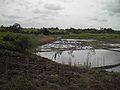 Warga menangkap ikan dalam sawah selama musim pra-panen
 -
 Balai kota dan stasiun pemancar seluler


Pranala luar[sunting | sunting sumber]
- Municipality of Quezon Diarsipkan 2007-03-12 di Wayback Machine.
- Republic Act No. 2418: An Act creating the Municipality of Quezon in the Province of Isabela
- Philippine Standard Geographic Code Diarsipkan 2012-04-13 di Wayback Machine.
- 1995 Philippine Census Information Diarsipkan 2009-08-14 di Wayback Machine.
- 2000 Philippine Census Information
- 2007 Philippine Census Information Diarsipkan 2008-11-20 di Wayback Machine.
- Local Governance Performance Management System Diarsipkan 2012-05-15 di Wayback Machine.
Koordinat: 17°19′4.58″N 121°36′45.55″E / 17.3179389°N 121.6126528°E
| Munisipalitas | Alicia • Angadanan • Aurora • Benito Soliven • Burgos • Cabagan • Cabatuan • Cordon • Delfin Albano • Dinapigue • Divilacan • Echague • Gamu • Jones • Luna • Maconacon • Mallig • Naguilian • Palanan • Quezon • Quirino • Ramon • Reina Mercedes • Roxas • San Agustin • San Guillermo • San Isidro • San Manuel • San Mariano • San Mateo • San Pablo • Santa Maria • Santo Tomas • Tumauini |
|---|---|
| Kota komponen | |
| Kota indenpenden | Santiago (Secara administratif independen dari provinsi, namun oleh National Statistics Office dimasukkan ke Isabela) |
Artikel bertopik geografi atau tempat Filipina ini adalah sebuah rintisan. Anda dapat membantu Wikipedia dengan mengembangkannya. |