
Berkas:NE 1200ad.jpg

Ukuran pratayang ini: 800 × 567 piksel. Resolusi lainnya: 320 × 227 piksel | 640 × 453 piksel | 1.024 × 725 piksel | 1.280 × 907 piksel | 1.464 × 1.037 piksel.
Ukuran asli (1.464 × 1.037 piksel, ukuran berkas: 1,43 MB, tipe MIME: image/jpeg)
Ringkasan


| Deskripsi |
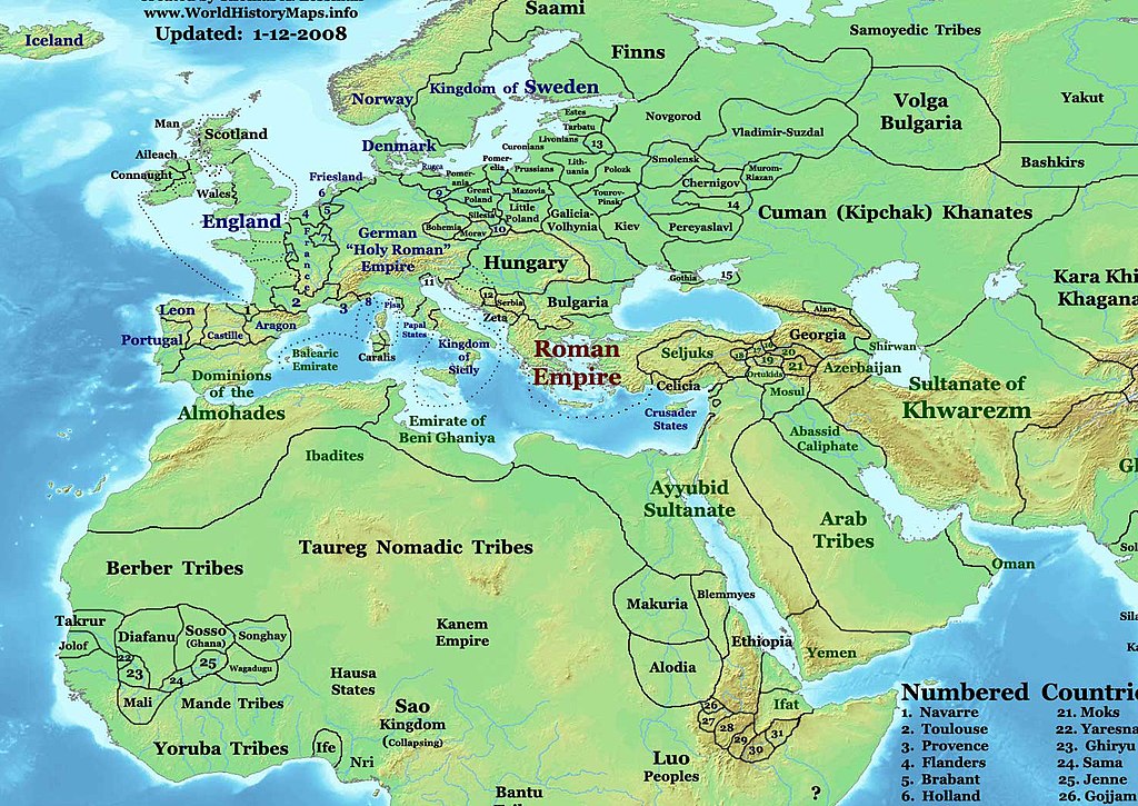
English: This image is a zoomed-in version of Eastern Hemisphere in 1200 AD (East-Hem_1200ad.jpg).
Author: Thomas A. Lessman. Source URL: http://www.ThomasLessman.com/History/images/East-Hem_1200ad.jpg. Image was created by me (Thomas Lessman) based on map of Eastern Hemisphere in 1200AD. Image is free for public and/or educational use. I would appreciate a mention if this image is used elsewhere. If anyone is interested in helping further this work, please contact Thomas Lessman at talessman@yis.us. Other Historical Maps by Thomas Lessman |
| Tanggal | 3 Desember 2007 (original upload date) |
| Sumber | Dipindahkan dari en.wikipedia ke Commons oleh Sdrtirs. |
| Pembuat | Talessman di Wikipedia bahasa Inggris |
Lisensi
Talessman di Wikipedia bahasa Inggris, pemilik hak cipta dari karya ini, dengan ini menerbitkan berkas ini di bawah ketentuan berikut:

|
Diizinkan untuk menyalin, mendistribusikan dan/atau memodifikasi dokumen ini di bawah syarat-syarat Lisensi Dokumentasi Bebas GNU, Versi 1.2 atau lebih baru yang diterbitkan oleh Free Software Foundation; tanpa Bagian Invarian, tanpa Teks Sampul Depan, dan tanpa Teks Sampul Belakang. Salinan lisensi dimasukkan ke bagian yang berjudul Lisensi Dokumentasi Bebas GNU. |
Berkas ini berlisensi di bawah lisensi Creative Commons Atribusi 3.0 Tanpa Adaptasi
Atribusi: Talessman di Wikipedia bahasa Inggris
- Anda diizinkan:
- untuk berbagi – untuk menyalin, mendistribusikan dan memindahkan karya ini
- untuk menggubah – untuk mengadaptasi karya ini
- Berdasarkan ketentuan berikut:
- atribusi – Anda harus mencantumkan atribusi yang sesuai, memberikan pranala ke lisensi, dan memberi tahu bila ada perubahan. Anda dapat melakukannya melalui cara yang Anda inginkan, namun tidak menyatakan bahwa pemberi lisensi mendukung Anda atau penggunaan Anda.
Anda dapat memilih lisensi pilihan Anda.
Log pengunggahan asli
Halaman deskripsi aslinya ada di sini. Semua nama pengguna berikut merujuk pada en.wikipedia.
- 2008-01-14 21:44 Talessman 1439×1035×8 (475084 bytes) Corrected borders of Scandinavia
- 2008-01-11 22:15 Talessman 1457×1002×8 (467243 bytes) Corrected some borders in Africa, made some names easier to read, etc.
- 2007-12-03 19:50 Talessman 1647×1270×8 (602681 bytes) This image is a zoomed-in version of [http://en.wikipedia.org/wiki/Image:East-Hem_800ad.jpg Eastern Hemisphere in 800 AD]. [[Image:East-Hem_800ad.jpg|thumb|300px|left|Eastern Hemisphere in 800 AD.]] Author: Thomas A. Lessman. Source URL: h
Riwayat berkas
Klik pada tanggal/waktu untuk melihat berkas ini pada saat tersebut.
| Tanggal/Waktu | Miniatur | Dimensi | Pengguna | Komentar | |
|---|---|---|---|---|---|
| terkini | 11 Januari 2009 21.17 | | 1.464 × 1.037 (1,43 MB) | Ukabia | {{Information |Description= |Source= |Date= |Author= |Permission= |other_versions= }} |
| 10 April 2008 01.22 |  | 1.439 × 1.035 (464 KB) | File Upload Bot (Magnus Manske) | {{BotMoveToCommons|en.wikipedia}} {{Information |Description={{en|thumb|300px|left|Eastern Hemisphere in 1200 AD. This image is a zoomed-in version of [http://en.wikipedia.org/wiki/Image:East-Hem_1200ad.jpg Eastern Hem |
Penggunaan berkas
Halaman berikut menggunakan berkas ini:
Penggunaan berkas global
Wiki lain berikut menggunakan berkas ini:
- Penggunaan pada azb.wikipedia.org
- Penggunaan pada en.wikipedia.org
- Penggunaan pada es.wikipedia.org
- Penggunaan pada ka.wikipedia.org
- Penggunaan pada ru.wikipedia.org
- Penggunaan pada sco.wikipedia.org