
Berkas:DETAIL SHOWING GRILLE, AND CONTROL FOR AIR DUCT, FIRST FLOOR, CENTRAL ROOM, EAST WALL - Montgomery County Courthouse (1891), Court House Square, Rockville, Montgomery County, MD HABS MD,16-ROCVI,4-18.tif

Ukuran pratayang JPG ini dari berkas TIF ini: 426 × 599 piksel Resolusi lainnya: 171 × 240 piksel | 341 × 480 piksel | 546 × 768 piksel | 728 × 1.024 piksel | 1.457 × 2.048 piksel | 3.557 × 5.000 piksel.
Ukuran asli (3.557 × 5.000 piksel, ukuran berkas: 16,96 MB, tipe MIME: image/tiff)
Ringkasan
| DETAIL SHOWING GRILLE, AND CONTROL FOR AIR DUCT, FIRST FLOOR, CENTRAL ROOM, EAST WALL - Montgomery County Courthouse (1891), Court House Square, Rockville, Montgomery County, MD | ||||
|---|---|---|---|---|
| Judul |
DETAIL SHOWING GRILLE, AND CONTROL FOR AIR DUCT, FIRST FLOOR, CENTRAL ROOM, EAST WALL - Montgomery County Courthouse (1891), Court House Square, Rockville, Montgomery County, MD |
|||
| Deskripsi |
Boucher, Jack E, photographer; Jandoli, Liz, transmitter |
|||
| Depicted place | Maryland; Montgomery County; Rockville | |||
| Tanggal | Documentation compiled after 1933 | |||
| Ukuran | 5 x 7 in. | |||
| Lokasi |
Library of Congress Prints and Photographs Division Washington, D.C. 20540 USA http://hdl.loc.gov/loc.pnp/pp.print |
|||
| Kode inventaris |
HABS MD,16-ROCVI,4-18 |
|||
| Tipe akuisisi |
|
|||
| Catatan |
|
|||
| Sumber | https://www.loc.gov/pictures/item/md0990.photos.082664p | |||
| Izin (Menggunakan kembali berkas ini) |
|
|||

| Lokasi objek | | Lihat gambar ini dan gambar di sekitarnya di: OpenStreetMap |
|---|
Riwayat berkas
Klik pada tanggal/waktu untuk melihat berkas ini pada saat tersebut.
| Tanggal/Waktu | Miniatur | Dimensi | Pengguna | Komentar | |
|---|---|---|---|---|---|
| terkini | 22 Juli 2014 17.46 | 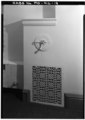 | 3.557 × 5.000 (16,96 MB) | Fæ | GWToolset: Creating mediafile for Fæ. HABS 21 July 2014 (1601:1800) |
Penggunaan berkas
Halaman berikut menggunakan berkas ini:
Penggunaan berkas global
Wiki lain berikut menggunakan berkas ini:
- Penggunaan pada en.wikipedia.org