
Berkas:Venusvulkan Tick-Typ.jpg

Ukuran asli (1.637 × 1.433 piksel, ukuran berkas: 770 KB, tipe MIME: image/jpeg)
| Deskripsi |
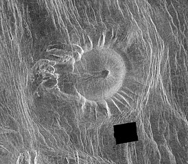
This Magellan image is of an area located in the Eistla Region [Error: This is in the Alpha Regio[1]] of Venus in the southern hemisphere and is centered at 5.5 degrees east longitude, 18 degrees south latitude. It is 122 kilometers (76 miles) across east to west and 107 kilometers (66 miles) north to south. North is at the top of the image. Shown is an unusual volcanic edifice unlike all others previously observed. It is approximately 66 kilometers (41 miles) across at the base and has a relatively flat, slightly concave summit 35 kilometers (22 miles) in diameter. The sides of the edifice are characterized by radiating ridges and valleys that impart a fluted appearance. To the west, the rim of the structure appears to have been breached by dark lava flows that emanated from a shallow summit pit approximately 5 kilometers (3 miles) in diameter and traveled west along a channel approximately 5 kilometers wide and 27 kilometers (17 miles) long. A series of coalescing, collapsed pits 2 to 10 kilometers (1.2 to 6.2 miles) in diameter are located 10 kilometers (6 miles) west of the summit. The edifice and western pits are circumscribed by faint, concentric lineaments up to 70 kilometers (43 miles) in diameter. A series of north northwest trending graben are deflected eastward around the edifice; the interplay of these graben and the fluted rim of the edifice produce a distinctive scalloped pattern in the image. Several north northwest trending lineaments cut directly across the summit region. This peculiar volcanic construct is located 25 to 30 kilometers (15 to 19 miles) north of Alpha Regio, a highly deformed region of tessera terrain. A collection of at least six similar volcanoes has been observed near Thetis Regio, a region of tessera within Aphrodite Terra. Thus, these unusual constructs tentatively appear to be spatially associated with regions of tessera. A tessera is a complex, deformed terrain on Venus consisting of at least two sets of intersecting ridges and troughs. The implications of this spatial association on the unusual morphology of these constructs are being investigated. The feature is unnamed as for 2016 (a map of the region) |
| Tanggal | image published 29. Jan. 1996 |
| Sumber |
NASA planetary photojournal |
| Pembuat | NASA/JPL |
| Izin (Menggunakan kembali berkas ini) |
Copyright information from http://www.jpl.nasa.gov/images/policy/index.cfm - Unless otherwise noted, images and video on JPL public web sites (public sites ending with a jpl.nasa.gov address) may be used for any purpose without prior permission [...] |
Gambar atau video ini telah dikatalogkan oleh salah satu pusat penelitian milik National Aeronautics and Space Administration (NASA)dibawah ID Foto: PIA00089. Label ini tidak menunjukkan status hak cipta dari berkas. Label hak cipta yang biasa tetap dibutuhkan. Lihat Commons:Lisensi. Bahasa lain:
|
| Berkas ini berada dalam domain publik di Amerika Serikat karena semata-mata diciptakan oleh NASA. Kebijakan hak cipta NASA menyatakan bahwa "materi NASA tidak dilindungi oleh hak cipta kecuali dicatat". (Lihat Template:PD-USGov, Halaman kebijakan hak cipta NASA atau JPL Image Use Policy.) | ||
 |
Peringatan:
|
Riwayat berkas
Klik pada tanggal/waktu untuk melihat berkas ini pada saat tersebut.
| Tanggal/Waktu | Miniatur | Dimensi | Pengguna | Komentar | |
|---|---|---|---|---|---|
| terkini | 12 Februari 2006 22.19 | | 1.637 × 1.433 (770 KB) | Arnomane | higher resolution |
| 2 September 2005 17.01 |  | 1.068 × 935 (285 KB) | Lotse | *'''Original Caption Released with Image:''' This Magellan image is of an area located in the Eistla Region of Venus in the southern hemisphere and is centered at 5.5 degrees east longitude, 18 degrees south latitude. It is 122 kilometers (76 miles) acros |
Penggunaan berkas
2 halaman berikut menggunakan berkas ini:
Penggunaan berkas global
Wiki lain berikut menggunakan berkas ini:
- Penggunaan pada ar.wikipedia.org
- Penggunaan pada de.wikipedia.org
- Penggunaan pada en.wikipedia.org
- Penggunaan pada eu.wikipedia.org
- Penggunaan pada he.wikipedia.org
- Penggunaan pada hu.wikipedia.org
- Penggunaan pada nl.wikipedia.org
- Penggunaan pada ro.wikipedia.org
- Penggunaan pada ru.wikipedia.org
- Penggunaan pada sr.wikipedia.org
- Penggunaan pada uk.wikipedia.org
- Penggunaan pada zh.wikipedia.org