
Berkas:T and O map Guntherus Ziner 1472.jpg
Ukuran pratayang ini: 600 × 600 piksel. Resolusi lainnya: 240 × 240 piksel | 480 × 480 piksel | 864 × 864 piksel.
Ukuran asli (864 × 864 piksel, ukuran berkas: 279 KB, tipe MIME: image/jpeg)
Ringkasan
| Seniman/Pembuat |
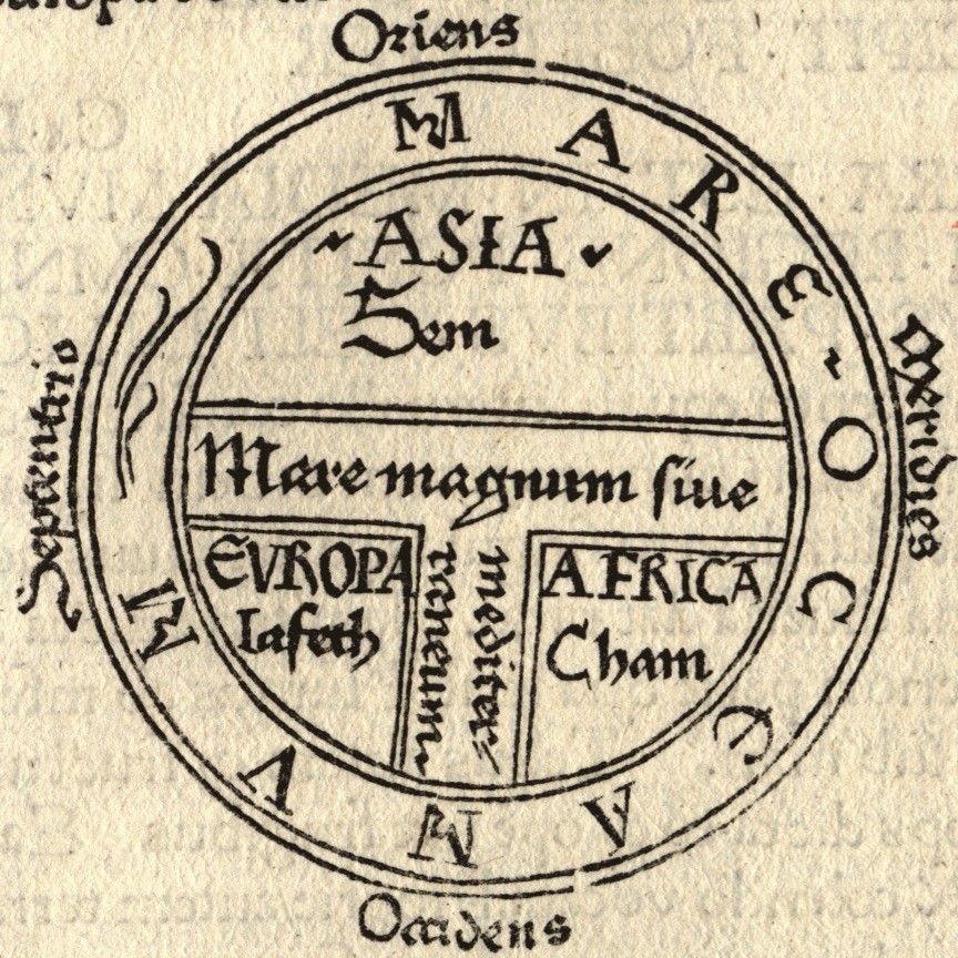
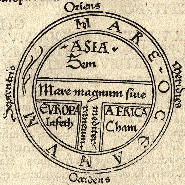
Isidore of Seville |
| Deskripsi |
|
| Sumber/Fotografer |

Lisensi
|
Ini adalah suatu perbanyakan fotografis dari sebuah karya seni dua dimensi. Karya seni tersebut berada pada domain publik karena alasan berikut:
Posisi resmi Wikimedia Foundation adalah bahwa "faithful reproductions of two-dimensional public domain works of art are public domain, and that claims to the contrary represent an assault on the very concept of a public domain". Untuk detilnya, lihat Commons:When to use the PD-Art tag.
Oleh karena itu, perbanyakan fotografis ini juga dianggap berada pada domain publik. Mohon diperhatikan bahwa hukum lokal mungkin saja melarang atau membatasi penggunaan kembali berkas ini di wilayah hukum anda. Lihat Commons:Reuse of PD-Art photographs. | ||||
Riwayat berkas
Klik pada tanggal/waktu untuk melihat berkas ini pada saat tersebut.
| Tanggal/Waktu | Miniatur | Dimensi | Pengguna | Komentar | |
|---|---|---|---|---|---|
| terkini | 18 Agustus 2006 22.43 | | 864 × 864 (279 KB) | Ma xyz | Reverted to earlier revision |
| 18 Agustus 2006 22.42 |  | 224 × 238 (18 KB) | Ma xyz | Reverted to earlier revision | |
| 11 Agustus 2006 06.34 |  | 864 × 864 (279 KB) | Leinad-Z~commonswiki | Larger version, cropped from Image:T-O map 1472.jpg | |
| 24 Mei 2005 10.25 |  | 224 × 238 (18 KB) | Dbachmann | detail of Image:Etymologiae Guntherus Ziner 1472.jpg {{PD-art}} |
Penggunaan berkas
3 halaman berikut menggunakan berkas ini:
Penggunaan berkas global
Wiki lain berikut menggunakan berkas ini:
- Penggunaan pada ar.wikipedia.org
- Penggunaan pada arz.wikipedia.org
- Penggunaan pada ast.wikipedia.org
- Penggunaan pada be.wikipedia.org
- Penggunaan pada bg.wikipedia.org
- Penggunaan pada bn.wikipedia.org
- Penggunaan pada bo.wikipedia.org
- Penggunaan pada br.wikipedia.org
- Penggunaan pada bs.wikipedia.org
- Penggunaan pada ca.wikipedia.org
- Penggunaan pada cs.wikipedia.org
- Penggunaan pada cv.wikipedia.org
- Penggunaan pada da.wikipedia.org
- Penggunaan pada de.wikipedia.org
- Penggunaan pada de.wikibooks.org
- Penggunaan pada el.wikipedia.org
- Penggunaan pada en.wikipedia.org
- Christendom
- Cartography
- Europe
- Japheth
- Shem
- Semitic people
- Generations of Noah
- Old World
- T and O map
- Japhetites
- User:Nurg/Continent
- Racial antisemitism
- Talk:Eurocentrism
- Continent
- Hamites
- Fantasy cartography
- Günther Zainer
- God's Philosophers
- Cartographic propaganda
- Wikipedia:Reference desk/Archives/Humanities/2016 November 20
Lihat lebih banyak penggunaan global dari berkas ini.