
Berkas:SaylorvilleMines.png
Tak tersedia resolusi yang lebih tinggi.
SaylorvilleMines.png (586 × 530 piksel, ukuran berkas: 65 KB, tipe MIME: image/png)
Ringkasan
| Deskripsi |
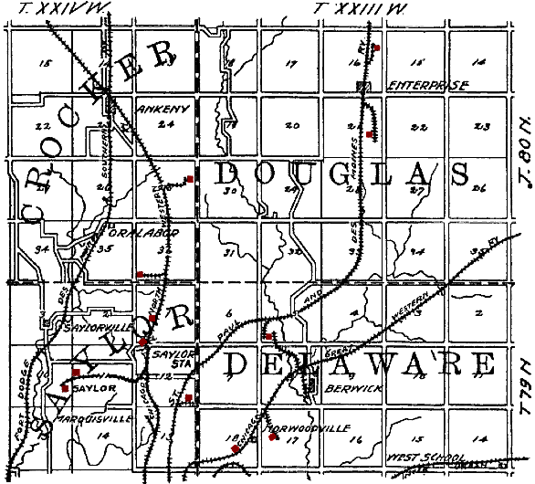
English: Original caption: "Figure 35. Map showing location of principal Polk County mines outside of the Des Moines district." en:Saylorville, Iowa is in the lower left quadrant. Mines have been tinted red by the uploader. The railroads shown on the map are: en:Fort Dodge, Des Moines and Southern Railroad, en:Chicago and North Western Railroad, en:St. Paul and Des Moines Railroad, en:Chicago Great Western Railroad and an unidentified en:Interurban. |
| Tanggal | |
| Sumber | The Coal Deposits of Iowa, Chapter I of Iowa Geological Survey Annual Report, 1908 |
| Pembuat | Henry Hinds |
| Lokasi kamera | | Lihat gambar ini dan gambar di sekitarnya di: OpenStreetMap |
|---|
Lisensi
This media file is in the public domain in the United States. This applies to U.S. works where the copyright has expired, often because its first publication occurred prior to January 1, 1929, and if not then due to lack of notice or renewal. See this page for further explanation.
|
 | |
 |
This image might not be in the public domain outside of the United States; this especially applies in the countries and areas that do not apply the rule of the shorter term for US works, such as Canada, Mainland China (not Hong Kong or Macao), Germany, Mexico, and Switzerland. The creator and year of publication are essential information and must be provided. See Wikipedia:Public domain and Wikipedia:Copyrights for more details.
|
Riwayat berkas
Klik pada tanggal/waktu untuk melihat berkas ini pada saat tersebut.
| Tanggal/Waktu | Miniatur | Dimensi | Pengguna | Komentar | |
|---|---|---|---|---|---|
| terkini | 19 Agustus 2009 15.50 | | 586 × 530 (65 KB) | Douglas W. Jones | {{Information |Description={{en|1=Original caption: "Figure 35. Map showing location of principal Polk County mines outside of the Des Moines district." en:Saylorville, Iowa is in the lower left quadrant. Mines have been tinted red by the uploader |
Penggunaan berkas
Halaman berikut menggunakan berkas ini:
Penggunaan berkas global
Wiki lain berikut menggunakan berkas ini:
- Penggunaan pada en.wikipedia.org
- Penggunaan pada es.wikipedia.org
- Penggunaan pada ht.wikipedia.org
- Penggunaan pada ro.wikipedia.org
- Penggunaan pada www.wikidata.org