
Berkas:Santa Fe Route Map 1891.jpg
Ukuran asli (1.435 × 1.023 piksel, ukuran berkas: 355 KB, tipe MIME: image/jpeg)
Ringkasan
| Deskripsi |
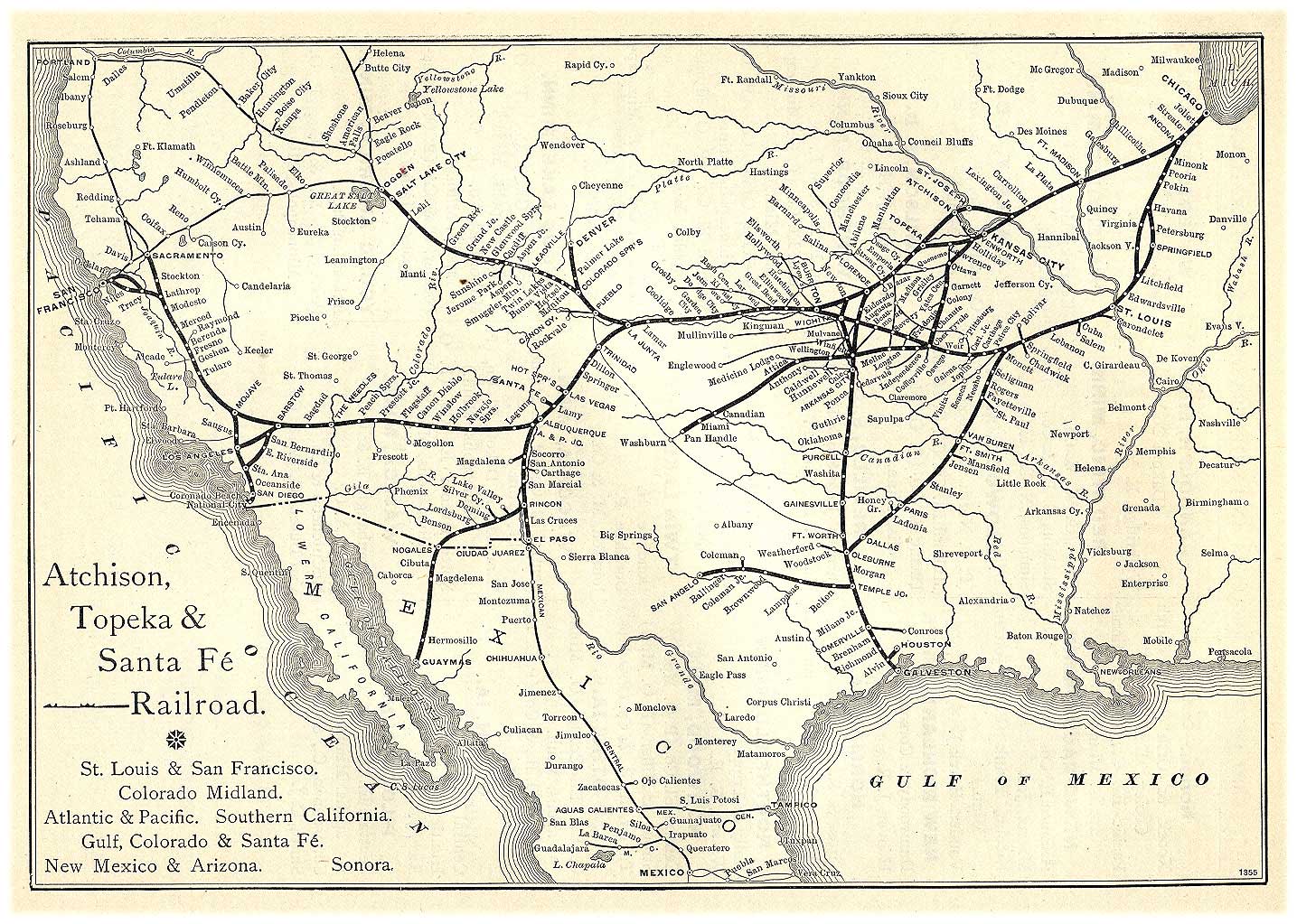
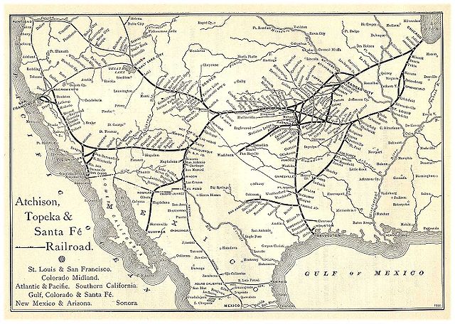
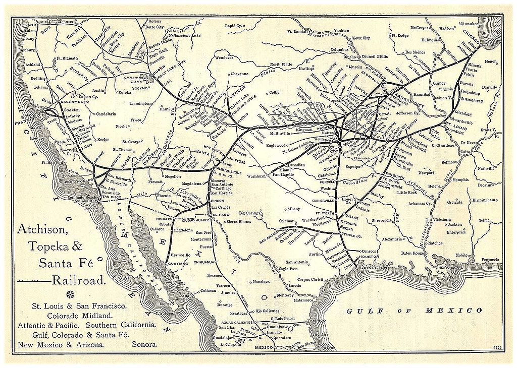
English: An Atchison, Topeka & Santa Fe Railway Route Map from the 1891 Grain Dealers and Shippers Gazetteer. |
| Tanggal |
1891 27 Mei 2006 (original upload date) |
| Sumber |
https://web.archive.org/web/20160328031916/http://www.memoriallibrary.com/Trans/RRGaz/ATSF/map.htm Transfered by User:Jmabel from en-wiki, where this was inappropriately named as Santa_Fe_Route_Map_1881.jpg |
| Pembuat | Grain Commission Merchants, Chamber of Commerce, Minneapolis, Minnesota |
Lisensi
|
This work is in the public domain in its country of origin and other countries and areas where the copyright term is the author's life plus 70 years or fewer.
| |
| Berkas ini telah diidentifikasi bebas dari pembatasan menurut hukum hak cipta termasuk semua hak terkait dan relevan. | |
This media file is in the public domain in the United States. This applies to U.S. works where the copyright has expired, often because its first publication occurred prior to January 1, 1929, and if not then due to lack of notice or renewal. See this page for further explanation.
|
 | |
 |
This image might not be in the public domain outside of the United States; this especially applies in the countries and areas that do not apply the rule of the shorter term for US works, such as Canada, Mainland China (not Hong Kong or Macao), Germany, Mexico, and Switzerland. The creator and year of publication are essential information and must be provided. See Wikipedia:Public domain and Wikipedia:Copyrights for more details.
|
Log pengunggahan asli
- 2006-05-27 19:20 Lordkinbote 1435×1023×8 (363176 bytes) An Atchison, Topeka & Santa Fe Railway Route Map from the 1891 ''Grain Dealers and Shippers Gazetteer''. img url: http://www.memoriallibrary.com/Trans/RRGaz/ATSF/atchisontopeka.jpg [[Category:Atchison, Topeka and Santa Fe Railway images]]
Riwayat berkas
Klik pada tanggal/waktu untuk melihat berkas ini pada saat tersebut.
| Tanggal/Waktu | Miniatur | Dimensi | Pengguna | Komentar | |
|---|---|---|---|---|---|
| terkini | 24 Desember 2007 20.38 | | 1.435 × 1.023 (355 KB) | Jmabel | {{Information |Description={{en|An Atchison, Topeka & Santa Fe Railway Route Map from the 1891 (title ''Grain Dealers and Shippers Gazetteer''. en:Category:Atchison, Topeka and Santa Fe Railway images [[:en:Category:Historical maps of the United St |
Penggunaan berkas
Halaman berikut menggunakan berkas ini:
Penggunaan berkas global
Wiki lain berikut menggunakan berkas ini:
- Penggunaan pada ar.wikipedia.org
- Penggunaan pada ast.wikipedia.org
- Penggunaan pada ca.wikipedia.org
- Penggunaan pada en.wikipedia.org
- Penggunaan pada es.wikipedia.org
- Penggunaan pada fa.wikipedia.org
- Penggunaan pada gl.wikipedia.org
- Penggunaan pada he.wikipedia.org
- Penggunaan pada hr.wikipedia.org
- Penggunaan pada it.wikipedia.org
- Penggunaan pada ja.wikipedia.org
- Penggunaan pada ms.wikipedia.org
- Penggunaan pada pt.wikipedia.org
- Penggunaan pada ru.wikipedia.org
- Penggunaan pada sh.wikipedia.org
- Penggunaan pada simple.wikipedia.org
- Penggunaan pada zh.wikipedia.org