
Berkas:Qing Empire circa 1820 EN.svg

Ukuran pratayang PNG ini dari berkas SVG ini: 686 × 600 piksel Resolusi lainnya: 275 × 240 piksel | 549 × 480 piksel | 879 × 768 piksel | 1.172 × 1.024 piksel | 2.343 × 2.048 piksel | 849 × 742 piksel.
Ukuran asli (Berkas SVG, secara nominal 849 × 742 piksel, besar berkas: 548 KB)

|
This file requires updating because: The island of Sumatra as depicted on the small globe in the lower left is colliding with Atlantis (Tuva?) and a peninsula unknown to modern geography is extending off the western coast of India. The eastern coast of Taiwan was never under the sovereignty of the Qing Empire. In doing so, you could add a timestamp to the file.
|
Ringkasan
| Deskripsi |
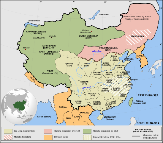
English: Qing Empire c. 1820 |
| Tanggal | |
| Sumber | Karya sendiri Incorporates modified version of File:Empire of the Great Qing (orthographic projection).svg. Note that the map excludes Tawang from Tibet. |
| Pembuat | Philg88: Attribution Wikimedia Foundation, www.wikimedia.org |
.svg)
Lisensi
Berkas ini dilisensikan di bawah lisensi Creative Commons Atribusi 4.0 Internasional.
- Anda diizinkan:
- untuk berbagi – untuk menyalin, mendistribusikan dan memindahkan karya ini
- untuk menggubah – untuk mengadaptasi karya ini
- Berdasarkan ketentuan berikut:
- atribusi – Anda harus mencantumkan atribusi yang sesuai, memberikan pranala ke lisensi, dan memberi tahu bila ada perubahan. Anda dapat melakukannya melalui cara yang Anda inginkan, namun tidak menyatakan bahwa pemberi lisensi mendukung Anda atau penggunaan Anda.
Riwayat berkas
Klik pada tanggal/waktu untuk melihat berkas ini pada saat tersebut.
| Tanggal/Waktu | Miniatur | Dimensi | Pengguna | Komentar | |
|---|---|---|---|---|---|
| terkini | 13 Juni 2021 20.03 | | 849 × 742 (548 KB) | SSH remoteserver | Reverted to version as of 03:34, 13 June 2021 (UTC) |
| 13 Juni 2021 18.31 |  | 849 × 742 (548 KB) | SSH remoteserver | Reverted to version as of 00:04, 13 June 2021 (UTC) | |
| 13 Juni 2021 03.34 |  | 849 × 742 (548 KB) | NorthTension | Reverted to version as of 07:44, 15 December 2020 (UTC) | |
| 13 Juni 2021 00.04 |  | 849 × 742 (548 KB) | SSH remoteserver | Burma was not a tributary. Please See: A Disguised Defeat https://www.jstor.org/stable/3876499; and Burmese Chronicles | |
| 15 Desember 2020 07.44 |  | 849 × 742 (548 KB) | LiliCharlie | Reverted to version as of 21:26, 10 October 2020 (UTC) — that's an embedded bitmap rather than a vector image — as Bidgee said, if you dispute it, upload under a new file name, perhaps as a PNG file | |
| 15 Desember 2020 07.13 |  | 1.172 × 1.024 (509 KB) | Бмхүн | Reverted to version as of 10:04, 24 March 2020 (UTC) | |
| 10 Oktober 2020 21.26 |  | 849 × 742 (548 KB) | Bidgee | Reverted to version as of 16:15, 29 April 2014 (UTC) if you dispute it, upload under a new file per COM:OVERWRITE | |
| 4 Oktober 2020 11.00 |  | 1.172 × 1.024 (509 KB) | Бмхүн | The oldest version has too much wrong,such as Guizhou should be Guangxi, Caton isn’t Guangdong, and manchus homeland located in south part of Manchuria | |
| 23 Juni 2020 16.54 |  | 849 × 742 (548 KB) | LiliCharlie | Reverted embedded bitmap version to true vector version as of 16:15, 29 April 2014 (UTC) | |
| 24 Maret 2020 10.04 |  | 1.172 × 1.024 (509 KB) | Anchuhu | Reverted to version as of 06:35, 9 January 2019 (UTC) the borders and provinces name are wrong |
Penggunaan berkas
3 halaman berikut menggunakan berkas ini:
Penggunaan berkas global
Wiki lain berikut menggunakan berkas ini:
- Penggunaan pada ar.wikipedia.org
- Penggunaan pada cdo.wikipedia.org
- Penggunaan pada cs.wikipedia.org
- Penggunaan pada da.wikipedia.org
- Penggunaan pada de.wikipedia.org
- Penggunaan pada el.wikipedia.org
- Penggunaan pada en.wikipedia.org
- China
- History of China
- History of Asia
- Imperialism
- History of East Asia
- Taiping Rebellion
- Manchu people
- History of Tibet
- Treaty of Nerchinsk
- Portal:China
- Portal:Asia
- History of Mongolia
- Amur Annexation
- Transition from Ming to Qing
- Settler colonialism
- Talk:Qing dynasty/Archive 5
- Tibet under Qing rule
- Xinjiang under Qing rule
- List of modern great powers
- Timeline of the Qing dynasty
- User:Falcaorib
- Talk:COVID-19 pandemic/Archive 2
- User talk:FuzionEXA
- User:Sanskar shingare/sandbox
- Penggunaan pada es.wikipedia.org
- Penggunaan pada et.wikipedia.org
- Penggunaan pada fa.wikipedia.org
- Penggunaan pada fr.wikipedia.org
Lihat lebih banyak penggunaan global dari berkas ini.