
Berkas:Persian Empire, 490 BC.png
Ukuran pratayang ini: 800 × 577 piksel. Resolusi lainnya: 320 × 231 piksel | 640 × 461 piksel | 946 × 682 piksel.
Ukuran asli (946 × 682 piksel, ukuran berkas: 159 KB, tipe MIME: image/png)
Ringkasan
| Deskripsi |
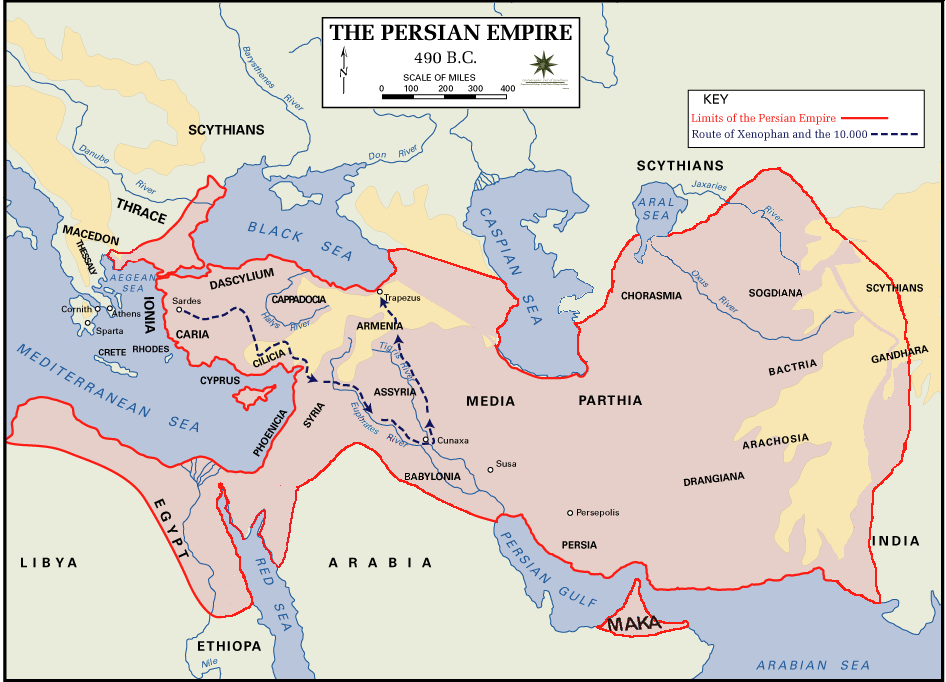
 English: Persian Empire, 490 BC, showing route of Cyrus the Younger, Xenophon and the 10.000.
Legends:
|
| Tanggal | |
| Sumber | The Department of History - United States Military Academy |
| Pembuat | DHUSMA |
| Izin (Menggunakan kembali berkas ini) |
In the public domain as original works of the United States federal government and/or military |
| Versi lainnya | For a version of this image altered to display better in Wikipedia articles (converted to PNG format, slightly cropped in File:Persian Empire, 490 BC.gif) y Italian version. |
Lisensi
Karya ini berada dalam domain publik di Amerika Serikat karena ini adalah karya yang disiapkan oleh seorang petugas atau karyawan dari Pemerintah Amerika Serikat sebagai bagian dari tugas resmi orang tersebut di bawah ketentuan Judul 17, Bab 1, Bagian 105 dari Kode Amerika Serikat. Lihat Hak cipta.
Catatan: Ini hanya berlaku untuk karya-karya asli dari Pemerintah Federal dan bukan karya setiap individual negara bagian, wilayah, persemakmuran, kabupaten, kota, atau subdivisi Amerika Serikat lainnya. Templat ini juga tidak berlaku untuk desain cap prangko yang diterbitkan oleh Layanan Pos Amerika Serikat sejak tahun 1978. (Lihat § 313.6(C)(1) of Compendium of U.S. Copyright Office Practices). Ini juga tidak berlaku untuk koin AS tertentu; lihat The US Mint Terms of Use.
|
 | |
| Berkas ini telah diidentifikasi bebas dari pembatasan menurut hukum hak cipta termasuk semua hak terkait dan relevan. | ||
Riwayat berkas
Klik pada tanggal/waktu untuk melihat berkas ini pada saat tersebut.
| Tanggal/Waktu | Miniatur | Dimensi | Pengguna | Komentar | |
|---|---|---|---|---|---|
| terkini | 2 Agustus 2015 02.11 | | 946 × 682 (159 KB) | History of Persia | Achaemenid Arabia. see wikipedia article about achaemenid arabia |
| 11 April 2013 11.21 |  | 942 × 684 (64 KB) | HistoryofIran | {{subst:Upload marker added by en.wp UW}} {{Information |Description = {{en|Added another region named Maka, it was listen on the Behistun inscription as part of the Achaemenid Empire.}} |Source = https://en.wikipedia.org/wiki/File:Persian_Empire,_490_... | |
| 10 April 2013 19.21 |  | 942 × 684 (64 KB) | HistoryofIran | Changed where Chorasmia was written, it was much closer to the Aral sea. | |
| 10 April 2013 19.19 |  | 942 × 684 (64 KB) | HistoryofIran | Added a more accurate map. | |
| 7 Desember 2012 22.55 |  | 942 × 684 (64 KB) | Geagea | Colchis and Caucasian Iberia. Not Georgia. | |
| 25 November 2012 16.24 |  | 942 × 684 (97 KB) | SilvioRusso | correction | |
| 27 Agustus 2009 00.49 |  | 942 × 684 (64 KB) | AnonMoos | Version of File:Persian Empire, 490 BC.gif altered to display better in Wikipedia articles (converted to PNG format, slightly cropped). == Summary == ; Description : Persian Empire, 490 BC ; Author/Source : [http://www.dean.usma.edu/history/ The Depa |
Penggunaan berkas
2 halaman berikut menggunakan berkas ini:
Penggunaan berkas global
Wiki lain berikut menggunakan berkas ini:
- Penggunaan pada ast.wikipedia.org
- Penggunaan pada bg.wikipedia.org
- Penggunaan pada cs.wikipedia.org
- Penggunaan pada da.wikipedia.org
- Penggunaan pada el.wikipedia.org
- Penggunaan pada en.wikipedia.org
- Penggunaan pada fa.wikipedia.org
- Penggunaan pada fr.wikipedia.org
- Penggunaan pada fy.wikipedia.org
- Penggunaan pada hr.wikipedia.org
- Penggunaan pada hy.wikipedia.org
- Penggunaan pada it.wikipedia.org
- Penggunaan pada ko.wikipedia.org
- Penggunaan pada ku.wikipedia.org
- Penggunaan pada la.wikipedia.org
- Penggunaan pada nl.wikipedia.org
- Penggunaan pada no.wikipedia.org
- Penggunaan pada pnb.wikipedia.org
- Penggunaan pada pnt.wikipedia.org
- Penggunaan pada ro.wikipedia.org
- Penggunaan pada ru.wikipedia.org
- Penggunaan pada sh.wikipedia.org
- Penggunaan pada sr.wikipedia.org
- Penggunaan pada sv.wikipedia.org
- Penggunaan pada tg.wikipedia.org
- Penggunaan pada tr.wikipedia.org
Lihat lebih banyak penggunaan global dari berkas ini.