
Berkas:Lockheed 8 Sirius 'Tingmissartoq' at the National Air and Space Museum, Washington DC.jpg

Ukuran asli (1.600 × 1.066 piksel, ukuran berkas: 503 KB, tipe MIME: image/jpeg)
| Deskripsi |
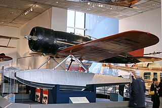
Every possible space in the aircraft was utilized, including the wings and floats, which contained the gasoline tanks. There was plenty of emergency equipment in case the Lindberghs had to make a forced landing in the frozen wilderness. From New York, the Lindberghs flew up the eastern border of Canada to Hopedale, Labrador. From Hopedale they made the first major overwater hop, 650 miles to Godthaab, Greenland, where the Sirius acquired its name—Tingmissartoq, which in Eskimo means "one who flies like a big bird." After crisscrossing Greenland to Baffin Island and back, and then on to Iceland, the Lindberghs proceeded to the major cities of Europe and as far east as Moscow, down the west coast of Africa, and across the South Atlantic to South America. where they flew down the Amazon, and then north through Trinidad and Barbados and back to the United States. They returned to New York on December 19, having traveled 30,000 miles to four continents and twenty-one countries. The information gained from the trip proved invaluable in planning commercial air transport routes for the North and South Atlantic. The aircraft was in the American Museum of Natural History in New York City until 1955. The AirForce Museum in Dayton, Ohio, then acquired it and transferred it to the Smithsonian in 1959. collections.nasm.si.edu/code/emuseum.asp?profile=objects&... |
| Tanggal | |
| Sumber | Lockheed 8 Sirius "Tingmissartoq" |
| Pembuat | Cliff from I now live in Arlington, VA (Outside Washington DC), USA |
| Lokasi kamera | | Lihat gambar ini dan gambar di sekitarnya di: OpenStreetMap |
|---|
Lisensi
- Anda diizinkan:
- untuk berbagi – untuk menyalin, mendistribusikan dan memindahkan karya ini
- untuk menggubah – untuk mengadaptasi karya ini
- Berdasarkan ketentuan berikut:
- atribusi – Anda harus mencantumkan atribusi yang sesuai, memberikan pranala ke lisensi, dan memberi tahu bila ada perubahan. Anda dapat melakukannya melalui cara yang Anda inginkan, namun tidak menyatakan bahwa pemberi lisensi mendukung Anda atau penggunaan Anda.
| This image was originally posted to Flickr by cliff1066™ at https://www.flickr.com/photos/28567825@N03/3344241041. It was reviewed on 15 November 2009 by FlickreviewR and was confirmed to be licensed under the terms of the cc-by-2.0. |
Riwayat berkas
Klik pada tanggal/waktu untuk melihat berkas ini pada saat tersebut.
| Tanggal/Waktu | Miniatur | Dimensi | Pengguna | Komentar | |
|---|---|---|---|---|---|
| terkini | 15 November 2009 18.01 | | 1.600 × 1.066 (503 KB) | Geo Swan | {{Information |Description=Every possible space in the aircraft was utilized, including the wings and floats, which contained the gasoline tanks. There was plenty of emergency equipment in case the Lindberghs had to make a forced landing in the frozen wil |
Penggunaan berkas
Halaman berikut menggunakan berkas ini:
Penggunaan berkas global
Wiki lain berikut menggunakan berkas ini:
- Penggunaan pada ar.wikipedia.org
- Penggunaan pada ast.wikipedia.org
- Penggunaan pada ca.wikipedia.org
- Penggunaan pada en.wikipedia.org
- Penggunaan pada es.wikipedia.org
- Penggunaan pada fa.wikipedia.org
- Penggunaan pada fr.wikipedia.org
- Penggunaan pada gl.wikipedia.org
- Penggunaan pada ja.wikipedia.org
- Penggunaan pada no.wikipedia.org
- Penggunaan pada pt.wikipedia.org
- Penggunaan pada vi.wikipedia.org
- Penggunaan pada www.wikidata.org