
Berkas:Eyjafjallajökull volcanic ash 17 April 2010.png
Tak tersedia resolusi yang lebih tinggi.
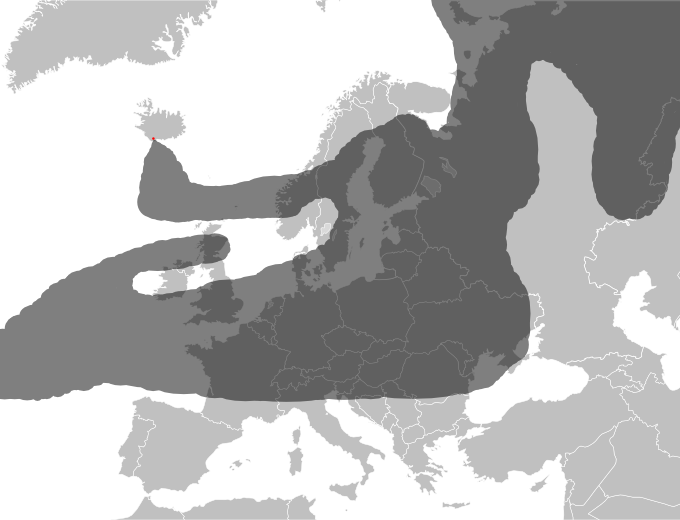
Eyjafjallajökull_volcanic_ash_17_April_2010.png (680 × 520 piksel, ukuran berkas: 127 KB, tipe MIME: image/png)
| Deskripsi |
Approximate drawing of estimated ash cloud from the Eyjafjallajökull eruption as of 17 April 2010 at 18:00 UTC. Source: http://www.metoffice.gov.uk/aviation/vaac/data/VAG_1271527299.png Newer map: File:Eyjafjallajökull volcanic ash 19 April 2010.png Updates at http://www.metoffice.gov.uk/aviation/vaac/vaacuk_vag.html |
| Tanggal | (UTC) |
| Sumber | |
| Pembuat |
|
| Ini merupakan gambar hasil penyuntingan yang berarti bahwa gambar tersebut telah diubah secara digital dari versi asli. Perubahan: drawed ash coverage. Versi asli dapat dilihat di sini: Blank map of Europe.svg:
|
Berkas on ipartandoan sian on Creative Commons Attribution-Share Alike 3.0 Unported partadoan.
- Anda diizinkan:
- untuk berbagi – untuk menyalin, mendistribusikan dan memindahkan karya ini
- untuk menggubah – untuk mengadaptasi karya ini
- Berdasarkan ketentuan berikut:
- atribusi – Anda harus mencantumkan atribusi yang sesuai, memberikan pranala ke lisensi, dan memberi tahu bila ada perubahan. Anda dapat melakukannya melalui cara yang Anda inginkan, namun tidak menyatakan bahwa pemberi lisensi mendukung Anda atau penggunaan Anda.
- berbagi serupa – Apabila Anda menggubah, mengubah, atau membuat turunan dari materi ini, Anda harus menyebarluaskan kontribusi Anda di bawah lisensi yang sama seperti lisensi pada materi asli.
Log pengunggahan asli
This image is a derivative work of the following images:
- File:Blank_map_of_Europe.svg licensed with Cc-by-sa-2.5
- 2008-09-17T09:50:25Z F7 680x520 (531491 Bytes)
- 2008-09-17T09:42:57Z F7 680x520 (2353 Bytes)
- 2008-05-26T19:04:07Z Collard 680x520 (531491 Bytes) uploading on behalf of [[User:Checkit]], direct complaints to him plox: 'Moved countries out of the "outlines" group, removed "outlines" style class, remove separate style information for Russia'
- 2008-04-30T01:38:52Z TimothyBourke 680x520 (531767 Bytes) Changed the country code of Serbia to RS per [http://en.wikipedia.org/wiki/Serbian_country_codes] and the file [http://www.iso.org/iso/iso3166_en_code_lists.txt].
- 2008-02-08T22:44:37Z CarolSpears 680x520 (531767 Bytes) validated
- 2007-07-10T11:47:59Z MrWeeble 680x520 (533112 Bytes) Updated to include British Crown Dependencies as seperate entities and regroup them as "British Islands", with some simplifications to the XML and CSS
- 2007-05-14T17:17:34Z Zirland 680x520 (540659 Bytes) serbia and montenegro
- 2007-03-30T20:40:49Z W!B: 680x520 (538830 Bytes) minor corr: update nl:Ijsselmeer, del fi:lakes (all small), add ru:lake Oneka (all ref maps.google), glued northern irland back to ie ;)
- 2007-02-05T18:44:32Z Maix 680x520 (538295 Bytes) cropped
- 2007-02-04T15:07:29Z Maix 680x520 (538310 Bytes) {{Information |Description=A blank Map of Europe in SVG format. Every country has an id which is its ISO-3116-1-ALPHA2 code in lower case for easy coloring. |Source=Image based on [[Image:Europe_countries.svg|]] by [[User:Ti
Uploaded with derivativeFX
Riwayat berkas
Klik pada tanggal/waktu untuk melihat berkas ini pada saat tersebut.
| Tanggal/Waktu | Miniatur | Dimensi | Pengguna | Komentar | |
|---|---|---|---|---|---|
| terkini | 17 April 2010 21.24 | | 680 × 520 (127 KB) | Hydrox | Enhanced approximation of the same source. |
| 17 April 2010 20.01 |  | 680 × 520 (127 KB) | Hydrox | Updated to reflect the data as of April 17th, 18:00 UTC (http://www.metoffice.gov.uk/aviation/vaac/data/VAG_1271527299.png) | |
| 16 April 2010 16.43 |  | 680 × 520 (127 KB) | Cogiati | {{Information |Description=Approximate drawing of estimated ash cloud from the Eyjafjallajökull eruption as of 17 April 2010 at 06:00 UTC. Source: http://www.metoffice.gov.uk/aviation/vaac/data/VAG_1271417376.png Updates at http://www.metoffice.gov.uk/a |
Penggunaan berkas
2 halaman berikut menggunakan berkas ini:
Penggunaan berkas global
Wiki lain berikut menggunakan berkas ini:
- Penggunaan pada an.wikipedia.org
- Penggunaan pada arz.wikipedia.org
- Penggunaan pada ca.wikipedia.org
- Penggunaan pada cs.wikipedia.org
- Penggunaan pada da.wikipedia.org
- Penggunaan pada de.wikipedia.org
- Penggunaan pada de.wikinews.org
- Penggunaan pada en.wikipedia.org
- Penggunaan pada en.wikinews.org
- Penggunaan pada eu.wikipedia.org
- Penggunaan pada fi.wikipedia.org
- Penggunaan pada fi.wikinews.org
- Penggunaan pada he.wikipedia.org
- Penggunaan pada hr.wikipedia.org
- Penggunaan pada hu.wikipedia.org
- Penggunaan pada hu.wikinews.org
- Penggunaan pada incubator.wikimedia.org
- Penggunaan pada it.wikipedia.org
- Penggunaan pada ja.wikipedia.org
- Penggunaan pada jv.wikipedia.org
- Penggunaan pada km.wikipedia.org
- Penggunaan pada nl.wikipedia.org
- Penggunaan pada no.wikipedia.org
- Penggunaan pada pl.wikipedia.org
- Penggunaan pada pl.wikinews.org
- Penggunaan pada ru.wikipedia.org
- Penggunaan pada sh.wikipedia.org
- Penggunaan pada sr.wikipedia.org
- Penggunaan pada sv.wikipedia.org
- Penggunaan pada tr.wikinews.org
- Penggunaan pada uk.wikipedia.org