
Berkas:Armadillo range expansion.png
Tak tersedia resolusi yang lebih tinggi.
Armadillo_range_expansion.png (420 × 290 piksel, ukuran berkas: 19 KB, tipe MIME: image/png)
Ringkasan
| Deskripsi |
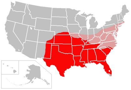
English: Map of the range of the Nine-banded Armadillo in the United States, created by user:Caliga10. This map is based in part on the following maps:
with supplemental information folded into it related to the appearance of the Nine-banded Armadillo in southern Illinois, obtained from the Illinois Natural History Survey, and supplemental information related to the appearance of the Nine-banded Armadillo in western Kentucky, from [1] (anecdotal to be sure, but the Kentucky Department of Fish and Wildlife seems to agree). The areas colored red indicate present range of the Nine-banded Armadillo in the United States, as of approximately 2006, and the areas colored pink are areas in which the species should eventually be able to establish itself based on climate and soil conditions, according to the first source cited above. That source also indicated large areas of the west coast of the United States as being suitable for armadillo expansion, but that would depend on human intervention as the armadillo is not likely to be able to establish itself in points westward (i.e. the Rocky Mountains) which lie between its current range and the Pacific coast.עברית: תחום ההתפשטות של ארמדיל תשע-הטבעות, נכון ל2009–2010 ועתידי |
| Tanggal | 4 Desember 2006 (original upload date) |
| Sumber | Own work by the original uploader |
| Pembuat | Caliga10 di Wikipedia bahasa Inggris |
Lisensi
| Karya ini dilepaskan ke domain umum oleh pemiliknya, Caliga10 di Wikipedia bahasa Inggris. Lisensi ini berlaku di seluruh dunia. Di sejumlah negara, tindakan ini tidak memungkinkan secara sah; bila seperti itu: Caliga10 memberikan siapa pun hak untuk menggunakan karya ini untuk tujuan apa pun, tanpa persyaratan apa pun, kecuali yang ditetapkan oleh hukum. |
Log pengunggahan asli
Dipindahkan dari he.wikipedia ke Commons oleh Fxp300.
Halaman deskripsi aslinya ada di sini. Semua nama pengguna berikut merujuk pada he.wikipedia.
- 2013-02-18 12:28 Manedwolf 420×290× (19845 bytes) == תקציר == {{מידע| |תיאור=תחום ההתפשטות של ארמדיל תשע-הטבעות, נכון ל2009–2010 ועתידי. |מקור=http://en.wikipedia.org/wiki/File:Armadillo_range_expansion.png |תאריך יצירה=כתוב ש...
Halaman deskripsi aslinya ada di sini. Semua nama pengguna berikut merujuk pada en.wikipedia.
- 2009-12-15 00:46 Caliga10 420×290× (19845 bytes) New version of this map for late 2009-early 2010, based on newspaper accounts that the armadillo is now moving into North Carolina.
- 2009-07-06 15:54 Caliga10 420×290× (19826 bytes) Uploaded a new version of this file which reflects expansion through mid-2009. The only significant change is the addition of most of East Tennessee per this source article: <ref>http://www.knoxnews.com/news/2009/jul/03/keeping-all-fingers-intact/</ref>-
- 2008-10-30 02:20 Caliga10 420×290× (24765 bytes) updated version of my armadillo range/expansion map from 2006 which factors in new source data indicating the armadillo's expansion has continued.
- 2006-12-04 00:47 Caliga10 420×290× (25087 bytes) Map of the range of the [[Nine-banded Armadillo]] in the [[United States]], created by [[user:Caliga10]]. This map is based in part on the following maps: [http://justinsomnia.org/images/armadillo_range.png Armadillo Range] [http://www.mnh.si.edu/mna//i
Riwayat berkas
Klik pada tanggal/waktu untuk melihat berkas ini pada saat tersebut.
| Tanggal/Waktu | Miniatur | Dimensi | Pengguna | Komentar | |
|---|---|---|---|---|---|
| terkini | 13 September 2013 23.56 | | 420 × 290 (19 KB) | OgreBot | (BOT): Reverting to most recent version before archival |
| 13 September 2013 23.56 |  | 420 × 290 (19 KB) | OgreBot | (BOT): Uploading old version of file from en.wikipedia; originally uploaded on 2009-07-06 15:54:17 by Caliga10 | |
| 13 September 2013 23.56 |  | 420 × 290 (24 KB) | OgreBot | (BOT): Uploading old version of file from en.wikipedia; originally uploaded on 2008-10-30 02:20:28 by Caliga10 | |
| 13 September 2013 23.56 |  | 420 × 290 (24 KB) | OgreBot | (BOT): Uploading old version of file from en.wikipedia; originally uploaded on 2006-12-04 00:47:02 by Caliga10 | |
| 18 Februari 2013 16.04 |  | 420 × 290 (19 KB) | HiyoriX | {{Information |Description={{he|תחום ההתפשטות של ארמדיל תשע-הטבעות, נכון ל2009–2010 ועתידי}} |Source=Transferred from [http://he.wikipedia.org he.wikipedia]; transfer was stated to be made by User:Fxp300.<b... |
Penggunaan berkas
Halaman berikut menggunakan berkas ini:
Penggunaan berkas global
Wiki lain berikut menggunakan berkas ini:
- Penggunaan pada ceb.wikipedia.org
- Penggunaan pada en.wikipedia.org
- Penggunaan pada he.wikipedia.org
- Penggunaan pada ko.wikipedia.org
- Penggunaan pada pt.wikipedia.org