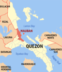
Mauban
Munisipalitas di Filipina | |||||
|---|---|---|---|---|---|
 | |||||
| Tempat | |||||
| |||||
| Negara berdaulat | Filipina | ||||
| Island group of the Philippines | Luzon | ||||
| Region di Filipina | Calabarzon | ||||
| Provinsi di Filipina | Quezon | ||||
| Negara | Filipina | ||||
| Penduduk | |||||
| Total | 71.081 (2020 ) | ||||
| Tempat tinggal | 17.587 (2020 ) | ||||
| Bahasa resmi | Tagalog | ||||
| Geografi | |||||
| Luas wilayah | 415,98 km² [convert: unit tak dikenal] | ||||
| Ketinggian | 58 m | ||||
| Berbatasan dengan | |||||
| Sejarah | |||||
| Pembuatan | 1583 | ||||
| Informasi tambahan | |||||
| Kode pos | 4330 | ||||
| Kode telepon | 42 | ||||
| Lain-lain | |||||
| Situs web | Laman resmi | ||||
Mauban adalah munisipalitas yang terletak di provinsi Quezon, Filipina.
Pada tahun 2010, munisipalitas ini memiliki populasi sebesar 60.536 jiwa dan 50.088 rumah tangga.
Pembagian wilayah[sunting | sunting sumber]
Secara administratif Mauban terbagi menjadi 40 barangay, yaitu:
- Abo-abo
- Alitap
- Baao
- Balaybalay
- Bato
- Cagbalete I
- Cagbalete II
- Cagsiay I
- Cagsiay II
- Cagsiay III
- Concepcion
- Liwayway
- Lucutan
- Luya-luya
- Macasin
- Lual (Pob.)
- Mabato (Pob.)
- Daungan (Pob.)
- Bagong Bayan (Pob.)
- Sadsaran (Pob.)
- Rizaliana (Pob.)
- Polo
- Remedios I
- Remedios II
- Rosario
- San Gabriel (dahulu bernama Tubug)[1]
- San Isidro
- San Jose
- San Lorenzo
- San Miguel
- San Rafael
- San Roque
- San Vicente
- Santa Lucia
- Santo Angel
- Santo Niño
- Santol
- Soledad
- Tapucan
- Lual Rural
Sarana pendidikan[sunting | sunting sumber]
Sarana pendidikan yang ada di wilayah ini antara lain:
- Balaybalay Elementary School
- Concepcion Elementary School
- Liwayway Elementary School
- Mabato Elementary School
- Mauban North Elementary School I
- Mauban North Elementary School II
- Remedios I Elementary School
- Remedios I Preschool (Annex) Bulusok
- Remedios II Elementary School
- San Lorenzo Elementary School
- San Miguel Elementary School
- SWA Elementary School
- Alitap Elementary School
- Bagong Bayan Elementary School
- Cagbalete I Annex Elementary School
- Cagbalete I Elementary School
- Cagbalete II (P.H. Dela Costa) Elementary School
- Cagsiay I Elementary School
- Cagsiay II Elementary School
- Cagsiay III Annex Elementary School
- Cagsiay III Elementary School
- Doña Aurora Elementary School
- Mauban South Central Elementary School
- Plaridel Elementary School
- Polo Elementary School
- Rosario Elementary School
- San Jose Elementary School
- Sta. Lucia Elementary School
- Sto. Niño Elementary School
- Cagbalete Island National High School
- Cagsiay I National High School
- Cagsiay III-Cagsiay I National High School Extension
- Dr. Maria D. Pastrana (Mauban Municipal) High School
- Liwayway National High School
- M.S. Enverga Memorial SAT Quezon National School of Arts & Trades
- Central Quezon Academy, terletak di Barangay Mabato[2]
- Mother Perpetua Parochial School, terletak di Barangay Lual Poblacion.[3]
- Pambayang Kolehiyo ng Mauban[4]
Referensi[sunting | sunting sumber]
- ^ "An Act Changing the Name of the Barrio of Tubog in the Municipality of Mauban, Province of Quezon, to San Gabriel". LawPH.com. Diakses tanggal 2011-04-12.
- ^ "Masterlist of Private Schools". Department of Education of the Philippines. Diarsipkan dari versi asli tanggal 2010-04-12. Diakses tanggal 2010-02-27.
- ^ "Mother Perpetua Parochial School (HS)". Municipal Government of Mauban. Diarsipkan dari versi asli tanggal 2011-08-20. Diakses tanggal 2010-02-27.
- ^ "The Directory of Higher Education Institutions and Programs as of November 11, 2009" (PDF). Commission on Higher Education, Philippines. Diarsipkan dari versi asli (PDF) tanggal 2015-06-20. Diakses tanggal 2010-02-27.
Pranala luar[sunting | sunting sumber]
- Municipality of Mauban Website Diarsipkan 2012-09-05 di Wayback Machine.
- Philippine Standard Geographic Code Diarsipkan 2009-11-14 di Wayback Machine.
- 1995 Philippine Census Information Diarsipkan 2011-06-24 di Wayback Machine.
- 2000 Philippine Census Information Diarsipkan 2010-01-30 di Wayback Machine.
- 2007 Philippine Census Information (1) Diarsipkan 2008-11-20 di Wayback Machine.
- 2007 Philippine Census Information (2) Diarsipkan 2009-03-02 di Wayback Machine.
- Local Governance Performance Management System Diarsipkan 2016-03-04 di Wayback Machine.
Koordinat: 14°11.167′N 121°43.163′E / 14.186117°N 121.719383°E

