
Defense Meteorological Satellite Program: Perbedaan antara revisi
Konten dihapus Konten ditambahkan
k ~cat |
|||
| Baris 14: | Baris 14: | ||
* [http://www.nro.gov/history/csnr/programs/docs/prog-hist-02.pdf R. Cargill Hall - A History of the Military Polar Orbiting Meteorolgical Satellite Program] {{Webarchive|url=https://www.webcitation.org/6HnsFIKzc?url=http://www.nro.gov/history/csnr/programs/docs/prog-hist-02.pdf |date=2013-07-02 }} |
* [http://www.nro.gov/history/csnr/programs/docs/prog-hist-02.pdf R. Cargill Hall - A History of the Military Polar Orbiting Meteorolgical Satellite Program] {{Webarchive|url=https://www.webcitation.org/6HnsFIKzc?url=http://www.nro.gov/history/csnr/programs/docs/prog-hist-02.pdf |date=2013-07-02 }} |
||
* [http://dmsp.ngdc.noaa.gov/ National Geophysical Data Center archive of DMSP data] {{Webarchive|url=https://web.archive.org/web/20051214025514/http://dmsp.ngdc.noaa.gov/ |date=2005-12-14 }} |
* [http://dmsp.ngdc.noaa.gov/ National Geophysical Data Center archive of DMSP data] {{Webarchive|url=https://web.archive.org/web/20051214025514/http://dmsp.ngdc.noaa.gov/ |date=2005-12-14 }} |
||
* [https://www. |
* [https://www.havarapor.com/ Hava Durumu] |
||
* [http://www.zianet.com/jpage/spysats/weather/dmsp.html The High Ground - DMSP] {{Webarchive|url=https://web.archive.org/web/20070214011934/http://www.zianet.com/jpage/spysats/weather/dmsp.html |date=2007-02-14 }} (dead-link) |
* [http://www.zianet.com/jpage/spysats/weather/dmsp.html The High Ground - DMSP] {{Webarchive|url=https://web.archive.org/web/20070214011934/http://www.zianet.com/jpage/spysats/weather/dmsp.html |date=2007-02-14 }} (dead-link) |
||
* [http://www.afrlhorizons.com/Briefs/Aug04/VS0308.html Air Force Research Lab Horizons magazine article] {{Webarchive|url=https://web.archive.org/web/20040913092215/http://www.afrlhorizons.com/Briefs/Aug04/VS0308.html |date=2004-09-13 }} |
* [http://www.afrlhorizons.com/Briefs/Aug04/VS0308.html Air Force Research Lab Horizons magazine article] {{Webarchive|url=https://web.archive.org/web/20040913092215/http://www.afrlhorizons.com/Briefs/Aug04/VS0308.html |date=2004-09-13 }} |
||
Revisi per 30 Mei 2022 19.26

.jpg)
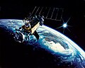
Defense Meteorological Satellite Program (DMSP) adalah program untuk memantau meteorologi, oseanografi, dan fisika matahari-terestrial untuk Departemen Pertahanan Amerika Serikat. Program ini dikelola oleh Air Force Space Command dengan operasi on-orbit disediakan oleh National Oceanic and Atmospheric Administration. Misi satelit terungkap Maret 1973. Mereka memberikan citra awan dari orbit polar yang matahari-sinkron pada ketinggian nominal 450 mil laut (830 km).[1] [2]
Foto galeri
-
 DMSP - Block 5D2
 -
 DMSP - Block 5D2
 -
 DMSP - Block 5D1


Referensi
- ^ "Schriever Airmen assist during satellite program move". schriever.af.mil. Diarsipkan dari versi asli tanggal 2009-12-03. Diakses tanggal 2008-02-04.
- ^ "DMSP(65-072A) - NSSDC ID: 1965-072A". NASA NSSDC. Diakses tanggal 2008-02-25.
- R. Cargill Hall - A History of the Military Polar Orbiting Meteorolgical Satellite Program Diarsipkan 2013-07-02 di WebCite
- National Geophysical Data Center archive of DMSP data Diarsipkan 2005-12-14 di Wayback Machine.
- Hava Durumu
- The High Ground - DMSP Diarsipkan 2007-02-14 di Wayback Machine. (dead-link)
- Air Force Research Lab Horizons magazine article Diarsipkan 2004-09-13 di Wayback Machine.
- Air Force news article
- SSEIS ionospheric instrument data page Diarsipkan 2008-04-04 di Wayback Machine.