Provinsi Konya: Perbedaan antara revisi
Konten dihapus Konten ditambahkan
k Konsistensi penamaan kategori |
Rescuing 1 sources and tagging 0 as dead.) #IABot (v2.0.8 |
||
| Baris 25: | Baris 25: | ||
* {{tr}} [http://www.konya.gov.tr Governor's web site] |
* {{tr}} [http://www.konya.gov.tr Governor's web site] |
||
* {{tr}} [http://www.turkcebilgi.com/Konya Information about Konya (Turkish)] |
* {{tr}} [http://www.turkcebilgi.com/Konya Information about Konya (Turkish)] |
||
* {{en}} [http://www.turkeyforecast.com/weather/konya/ Ramalan cuaca di Konya] |
* {{en}} [http://www.turkeyforecast.com/weather/konya/ Ramalan cuaca di Konya] {{Webarchive|url=https://web.archive.org/web/20080529075612/http://www.turkeyforecast.com/weather/konya/ |date=2008-05-29 }} |
||
{{Turki}} |
{{Turki}} |
||
Revisi terkini sejak 4 Maret 2021 20.35
Konya province
Konya ili | |
|---|---|
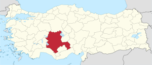
 Location of Konya Province in Turkey | |
| Country | Turkey |
| Region | Central Anatolia |
| Electoral district | Konya |
| Luas | |
| • Total | 38,257 km2 (14,771 sq mi) |
| Populasi (2010-12-31)[1] | |
| • Total | 2.013.845 |
| • Kepadatan | 53,000/km2 (140,000/sq mi) |
| Kode area telepon | 0332 |
| Pelat kendaraan | 42 |
| Situs web | konya.gov.tr |
Konya (Turki: Konya ili) adalah sebuah provinsi Turki yang berada di tengah-tengah Anatolia. Ibu kotanya adalah kota Konya.
Galeri[sunting | sunting sumber]
-
Makanan tradisional, Etliekmek
Referensi[sunting | sunting sumber]
- ^ Turkish Statistical Institute, MS Excel document – Population of province/district centers and towns/villages and population growth rate by provinces
Pranala luar[sunting | sunting sumber]
- (Turki) Governor's web site
- (Turki) Information about Konya (Turkish)
- (Inggris) Ramalan cuaca di Konya Diarsipkan 2008-05-29 di Wayback Machine.

