
Berkas:World trade map.PNG

Ukuran pratayang ini: 800 × 370 piksel. Resolusi lainnya: 320 × 148 piksel | 640 × 296 piksel | 1.357 × 628 piksel.
Ukuran asli (1.357 × 628 piksel, ukuran berkas: 41 KB, tipe MIME: image/png)
Ringkasan
| Deskripsi |
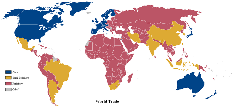
English: A world map of countries by trading status, late 20th century, using the world system differentiation into core countries, semi-periphery countries and periphery countries. Based on a list in Christopher Chase-Dunn, Yukio Kawano and Benjamin Brewer, Trade Globalization since 1795, American Sociological Review, 2000 February, Vol. 65 article, Appendix with the country list *Some countries with a population of less than one million were excluded from the analysis. |
| Tanggal | (UTC) |
| Sumber | Based on File:Anglosphere_map.png. |
| Pembuat | Lou Coban |
Lisensi
| Karya ini dilepaskan ke domain umum oleh pemiliknya, User:Naboc1. Lisensi ini berlaku di seluruh dunia. Di sejumlah negara, tindakan ini tidak memungkinkan secara sah; bila seperti itu: User:Naboc1 memberikan siapa pun hak untuk menggunakan karya ini untuk tujuan apa pun, tanpa persyaratan apa pun, kecuali yang ditetapkan oleh hukum.
|
Log pengunggahan asli
Dipindahkan dari en.wikipedia ke Commons oleh Piotrus menggunakan CommonsHelper.
Halaman deskripsi aslinya ada di sini. Semua nama pengguna berikut merujuk pada en.wikipedia.
- 2010-08-09 23:12 Altes 1357×628× (49371 bytes) fixed Brazil & Argentine
- 2010-06-11 01:32 Naboc1 1357×628× (49325 bytes) Included a new "other" category to denote countries with a population less than one million.
- 2010-06-10 18:09 Naboc1 1357×628× (48916 bytes) Updated Greenland as a core country since it is a part of Denmark
- 2010-06-10 05:40 Naboc1 1357×628× (48911 bytes) Updated some coutries that were incorrectly indicated as the wrong status.
- 2010-06-07 06:23 Naboc1 1357×628× (48895 bytes) {{Information |Description = A World map of countries by trading status |Source = |Date = ~~~~~ |Author = Lou Coban |Permission = |other_versions = }}
Riwayat berkas
Klik pada tanggal/waktu untuk melihat berkas ini pada saat tersebut.
| Tanggal/Waktu | Miniatur | Dimensi | Pengguna | Komentar | |
|---|---|---|---|---|---|
| terkini | 6 Juni 2022 00.20 | | 1.357 × 628 (41 KB) | Benjamintf1 | More colorblind friendly, as requested in talk page |
| 18 November 2010 18.18 |  | 1.357 × 628 (48 KB) | File Upload Bot (Magnus Manske) | {{BotMoveToCommons|en.wikipedia|year={{subst:CURRENTYEAR}}|month={{subst:CURRENTMONTHNAME}}|day={{subst:CURRENTDAY}}}} {{Information |Description={{en|A world map of countries by trading status, late 20th century, using the en:world system differen |
Penggunaan berkas
4 halaman berikut menggunakan berkas ini:
Penggunaan berkas global
Wiki lain berikut menggunakan berkas ini:
- Penggunaan pada ca.wikipedia.org
- Penggunaan pada cs.wikipedia.org
- Penggunaan pada de.wikipedia.org
- Penggunaan pada en.wikipedia.org
- Penggunaan pada en.wikiversity.org
- Penggunaan pada es.wikipedia.org
- Penggunaan pada fa.wikipedia.org
- Penggunaan pada gl.wikipedia.org
- Penggunaan pada hi.wikipedia.org
- Penggunaan pada hu.wikipedia.org
- Penggunaan pada hy.wikipedia.org
- Penggunaan pada ms.wikipedia.org
- Penggunaan pada pl.wikipedia.org
- Penggunaan pada pt.wikipedia.org
- Penggunaan pada uk.wikipedia.org
- Penggunaan pada uz.wikipedia.org
- Penggunaan pada zh.wikipedia.org