
Berkas:USS Wasp (CV-7) burning on 15 September 1942 (80-G-16331).jpg
Ukuran pratayang ini: 795 × 600 piksel. Resolusi lainnya: 318 × 240 piksel | 636 × 480 piksel | 1.018 × 768 piksel | 1.280 × 966 piksel | 2.560 × 1.931 piksel | 5.694 × 4.296 piksel.
Ukuran asli (5.694 × 4.296 piksel, ukuran berkas: 7,73 MB, tipe MIME: image/jpeg)
_burning_on_15_September_1942_(80-G-16331).jpg)
Ringkasan
| Fotografer |
Tak diketahui |
||||||||||||||||||||
| Deskripsi |
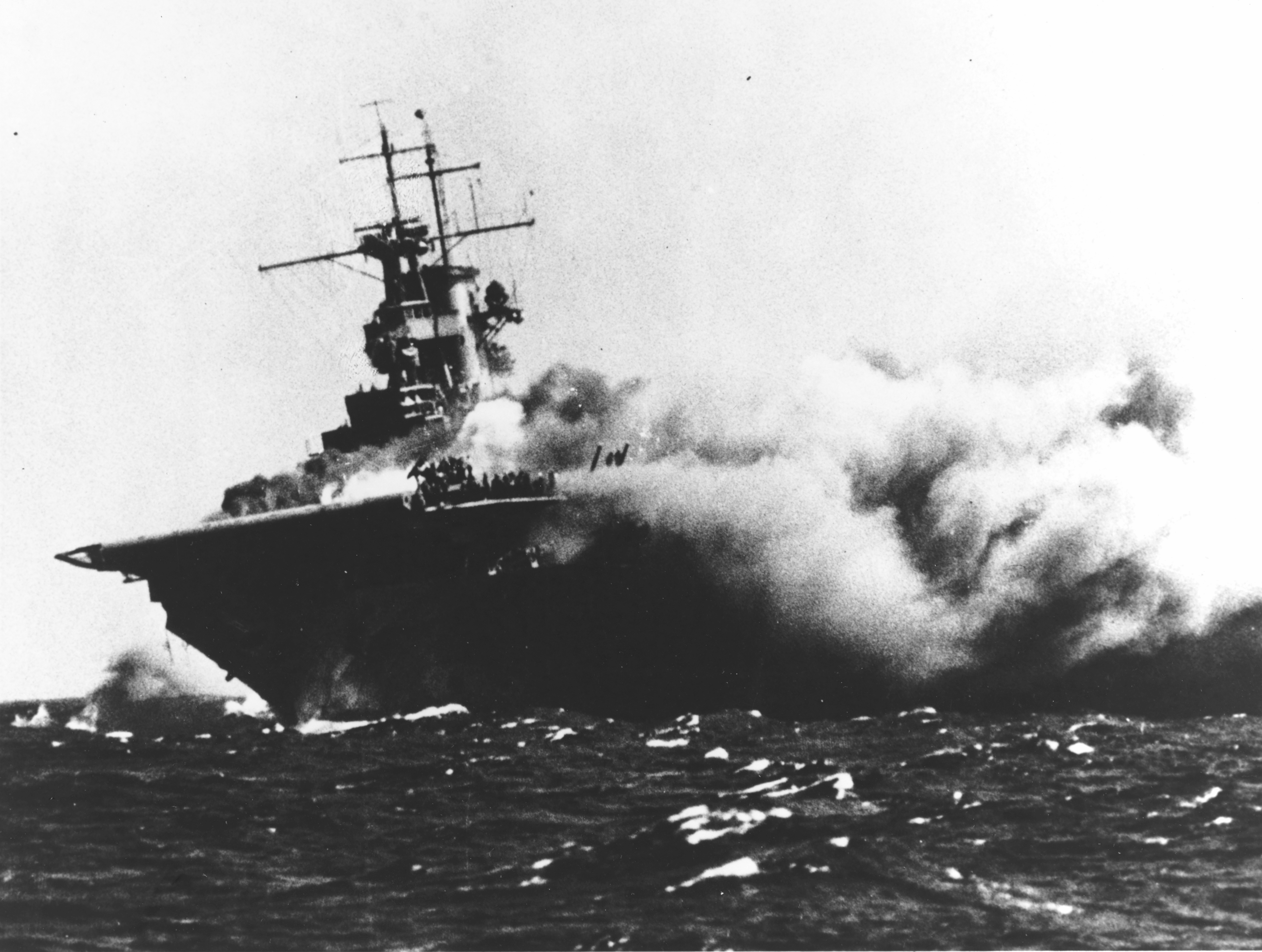
العربية: حاملة الطائرات التابعة للبحرية الأمريكية يو إس إس واسب (سي في-7) تشتعل بعد إصابتها بطوربيدات أطلقتها الغواصة اليابانية آي-19، في 15 سبتمبر 1942، أثناء عملها في جنوب غرب المحيط الهادئ لدعم قوات الحلفاء في غوادالكانال.
English: The U.S. Navy aircraft carrier USS Wasp (CV-7) burning and listing after she was torpedoed by the Japanese submarine I-19, on 15 September 1942, while operating in the Southwestern Pacific in support of forces on Guadalcanal. Note that the wartime censor has removed the CXAM-1 radar antenna, only its lower frame is still visible. |
||||||||||||||||||||
| Depicted place |
|
||||||||||||||||||||
| Tanggal | 15 September 1942 | ||||||||||||||||||||
| Koleksi |
|
||||||||||||||||||||
| Kode inventaris |
80-G-16331 |
||||||||||||||||||||
| Sumber | U.S. Navy photo 80-G-16331 | ||||||||||||||||||||
_burning_on_15_September_1942_(80-G-16331).jpg¶ms=-12.430000_N_0164.140556_E_globe:Earth_type:camera__&language=id)
Lisensi
| This image is available from the Naval History and Heritage Command under the digital ID 80-G-16331. Most of the photos found in the NHHC collection are in the public domain and may be downloaded and used without permissions or special requirements. Those which are not will be noted in the copyright section of the NHHC image description.[1] |
This file is a work of a sailor or employee of the U.S. Navy, taken or made as part of that person's official duties. As a work of the U.S. federal government, it is in the public domain in the United States.
|
 | |
| Berkas ini telah diidentifikasi bebas dari pembatasan menurut hukum hak cipta termasuk semua hak terkait dan relevan. | ||
Riwayat berkas
Klik pada tanggal/waktu untuk melihat berkas ini pada saat tersebut.
| Tanggal/Waktu | Miniatur | Dimensi | Pengguna | Komentar | |
|---|---|---|---|---|---|
| terkini | 21 Januari 2017 17.24 | | 5.694 × 4.296 (7,73 MB) | Cobatfor | new NHHC file |
| 28 Januari 2005 12.01 |  | 740 × 479 (69 KB) | W.wolny |
Penggunaan berkas
Halaman berikut menggunakan berkas ini:
Penggunaan berkas global
Wiki lain berikut menggunakan berkas ini:
- Penggunaan pada ar.wikipedia.org
- Penggunaan pada ast.wikipedia.org
- Penggunaan pada azb.wikipedia.org
- Penggunaan pada bg.wikipedia.org
- Penggunaan pada ca.wikipedia.org
- Penggunaan pada da.wikipedia.org
- Penggunaan pada de.wikipedia.org
- Penggunaan pada en.wikipedia.org
- Penggunaan pada es.wikipedia.org
- Penggunaan pada fr.wikipedia.org
- Penggunaan pada he.wikipedia.org
- Penggunaan pada hu.wikipedia.org
- Penggunaan pada it.wikipedia.org
- Penggunaan pada ja.wikipedia.org
- Penggunaan pada nl.wikipedia.org
- Penggunaan pada pl.wikipedia.org
Lihat lebih banyak penggunaan global dari berkas ini.
_burning_on_15_September_1942_(80-G-16331).jpg)
_burning_on_15_September_1942_(80-G-16331).jpg)