
Berkas:Santiam Pass.jpg

Ukuran asli (2.272 × 1.514 piksel, ukuran berkas: 1,86 MB, tipe MIME: image/jpeg)
|
This is an image of a place or building that is listed on the National Register of Historic Places in the United States of America. Its reference number is 99001285. |
| Deskripsi |
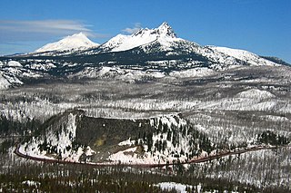
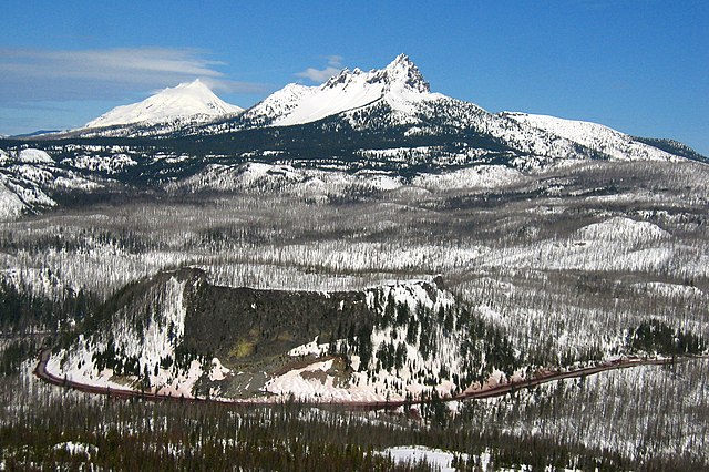
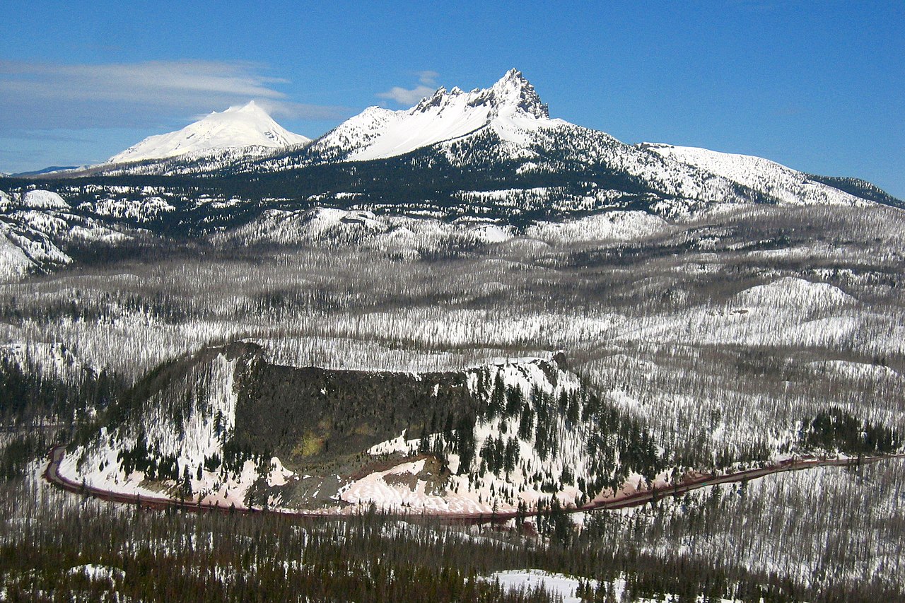
This is the majestic Santiam Pass, elevated at. 4817 ft above sea level in central Oregon Cascades. It is located about 18 mi (29 km) northwest of Sisters, between volcanic peaks of Three Fingered Jack to the north and Mount Washington to the south. U.S. Highway 20 connects eastern Oregon with the valley of the Santiam River on the west via Santiam Pass. One of the 19 or 20 lakes by the name of Lost Lake is located beside the highway just west of Santiam Pass. While the pass was known by native peoples, the first recorded crossing of the pass was in April 1859 by an expedition searching for a cattle trail over the Cascade Range from the Willamette Valley to Central Oregon. This expedition was led by Andrew Wiley, who reportedly climbed a tall tree on a mountain near Lost Prairie to help determine the route. Lost Prairie is located along Hackleman Creek between Fish Lake and Tombstone Prairie. Wiley later helped establish the Santiam Wagon Road. The prominent glaciated peak on the photo is the Three Fingered Jack, a Pleistocene volcano elevated 7,841 foot (2,390 meter), deeply glaciated and consists mainly of basaltic andesite lava. Mount Jefferson can also be seen from its left. The typical tuya volcano Hogg Rock, which is clearly visible from the photo below the Three Fingered Jack where US 20 Highway wraps in a nearly 180-degree curve below cliffs on the south and west sides, is only about 2 miles (3 km) north of Hayrick Butte, a somewhat larger tuya of similar age and composition. A tuya is a type of subglacial volcano, formed when lava erupts underneath an overlying glacier or ice sheet and then melts through to the surface and pools, producing the flat plateau on top with near-vertical walls along the ice-contact margin as the lava cools and hardens. Unlike most tuyas which have steep cliffs on all sides, Hogg Rock has a break in its cliffs on the east side, with a moderate slope which leads down to a small road and gravel pit. Santiam Pass was also the intended route over the Cascades for the Oregon Pacific Railroad, an early transcontinental railroad project led by Col. T. Egenton Hogg for whom Hogg Rock is named. Although the working line never extended east of Santiam Pass, the pass is today the eastern terminus of the Oregon Pacific Railroad Linear Historic District, which is listed on the US National Register of Historic Places. Taken from Hoodoo Ski Bowl summit. |
| Tanggal | |
| Sumber | santiam pass |
| Pembuat | Shaun Che from Oregon, US |
| Lokasi objek | | Lihat gambar ini dan gambar di sekitarnya di: OpenStreetMap |
|---|
Lisensi
- Anda diizinkan:
- untuk berbagi – untuk menyalin, mendistribusikan dan memindahkan karya ini
- untuk menggubah – untuk mengadaptasi karya ini
- Berdasarkan ketentuan berikut:
- atribusi – Anda harus mencantumkan atribusi yang sesuai, memberikan pranala ke lisensi, dan memberi tahu bila ada perubahan. Anda dapat melakukannya melalui cara yang Anda inginkan, namun tidak menyatakan bahwa pemberi lisensi mendukung Anda atau penggunaan Anda.
| Gambar ini, awalnya dikirim ke Flickr, ditinjau pada March 14, 2009 oleh administrator atau reviewer File Upload Bot (Magnus Manske), yang mengonfirmasi bahwa itu tersedia di Flickr di bawah lisensi yang dinyatakan pada tanggal itu. |
| Annotations | This image is annotated: View the annotations at Commons |
Riwayat berkas
Klik pada tanggal/waktu untuk melihat berkas ini pada saat tersebut.
| Tanggal/Waktu | Miniatur | Dimensi | Pengguna | Komentar | |
|---|---|---|---|---|---|
| terkini | 14 Maret 2009 06.29 | | 2.272 × 1.514 (1,86 MB) | File Upload Bot (Magnus Manske) | {{Information |Description= This is the majestic [http://en.wikipedia.org/wiki/Santiam_Pass Santiam Pass], elevated at. 4817 ft above sea level in central Oregon Cascades. It is located about 18 mi (29 km) northwest of Sisters, between volcanic peaks of |
Penggunaan berkas
Halaman berikut menggunakan berkas ini:
Penggunaan berkas global
Wiki lain berikut menggunakan berkas ini:
- Penggunaan pada en.wikipedia.org
- Penggunaan pada es.wikipedia.org
- Penggunaan pada fr.wikipedia.org
- Penggunaan pada it.wikipedia.org
- Penggunaan pada pt.wikipedia.org
- Penggunaan pada uk.wikipedia.org
- Penggunaan pada www.wikidata.org
- Penggunaan pada zh.wikipedia.org