
Berkas:PAK AU T1.svg

Ukuran pratayang PNG ini dari berkas SVG ini: 750 × 600 piksel Resolusi lainnya: 300 × 240 piksel | 600 × 480 piksel | 960 × 768 piksel | 1.280 × 1.024 piksel | 2.560 × 2.048 piksel | 1.000 × 800 piksel.
Ukuran asli (Berkas SVG, secara nominal 1.000 × 800 piksel, besar berkas: 19 KB)
Ringkasan
| Deskripsi |
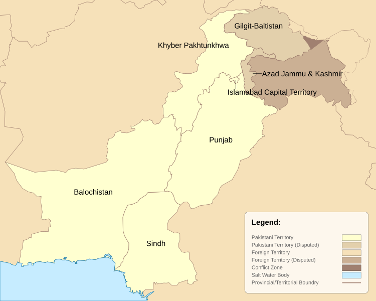
English: Pakistan Administrative Units - Tier 1. This map is based on the Pakistan location map and district maps obtained from respective government websites of Punjab, Sindh, Balochistan and Khyber Pakhtunkhwah. The map has been greatly simplified by reducing the number of data points to reduce file size and modified to include the latest districts as of 2010. |
| Tanggal | |
| Sumber | Karya sendiri |
| Pembuat | Schajee |
| Versi lainnya |
|


Lisensi
| Saya, pemegang hak cipta karya ini, merilis karya ini ke domain umum. Lisensi ini berlaku di seluruh dunia. Di sejumlah negara, tindakan ini tidak memungkinkan secara sah; bila seperti itu: Saya memberikan siapa pun hak untuk menggunakan karya ini untuk tujuan apa pun, tanpa persyaratan apa pun, kecuali yang ditetapkan oleh hukum. |
Riwayat berkas
Klik pada tanggal/waktu untuk melihat berkas ini pada saat tersebut.
| Tanggal/Waktu | Miniatur | Dimensi | Pengguna | Komentar | |
|---|---|---|---|---|---|
| terkini | 14 Februari 2021 23.04 | | 1.000 × 800 (19 KB) | M Imtiaz | As the previous uploader said, territorial disputes between China and India are irrelevant to this map as long as Pakistan does not claim those territories as part of itself, so I have changed the colour of Shaksgram, Aqsai Chin, etc. accordingly. |
| 25 Oktober 2020 08.43 |  | 1.000 × 800 (19 KB) | Swtadi143 | This should only show area in names whoch pakistan claims instead of showing areas disputed by India like shaksgam valley which is a dispute between china and India and not pakistan and India this map is wrong to show the administrative map of pakistan so I am reverting it Reverted to version as of 20:35, 2 June 2018 (UTC) | |
| 5 September 2019 18.49 |  | 1.000 × 800 (22 KB) | SPQR10 | Added Jammu & Kashmir,Siachen Galcier,Shaksgam Valley | |
| 2 Juni 2018 20.35 |  | 1.000 × 800 (19 KB) | ASDFGH | FATA merged into KP | |
| 10 Oktober 2010 18.37 |  | 1.000 × 800 (15 KB) | Schajee | Converted polygons to paths; added legend; | |
| 8 Oktober 2010 11.54 |  | 1.000 × 800 (18 KB) | Schajee | Adjusted text-alignment and shading for disputed territories | |
| 8 Oktober 2010 10.59 |  | 1.000 × 800 (18 KB) | Schajee | Reduced file size by simplifying outlines. Colors are now in accordance with Wikipedia Map Guidelines. | |
| 27 September 2010 02.37 |  | 685 × 500 (113 KB) | Schajee | Fixed Height/Width issue Changed Colors | |
| 27 September 2010 02.35 |  | 685 × 500 (114 KB) | Schajee | Reverted to version as of 18:26, 20 September 2010 | |
| 27 September 2010 02.34 |  | 512 × 512 (113 KB) | Schajee | Added pattern for disputed regions Fixed name for Khyber Pakhtunkhwah |
Penggunaan berkas
2 halaman berikut menggunakan berkas ini:
Penggunaan berkas global
Wiki lain berikut menggunakan berkas ini:
- Penggunaan pada be-tarask.wikipedia.org
- Penggunaan pada be.wikipedia.org
- Penggunaan pada bn.wikipedia.org
- Penggunaan pada en.wikipedia.org
- Penggunaan pada es.wikipedia.org
- Penggunaan pada fr.wikipedia.org
- Penggunaan pada is.wikipedia.org
- Penggunaan pada kn.wikipedia.org
- Penggunaan pada mzn.wikipedia.org
- Penggunaan pada pa.wikipedia.org
- Penggunaan pada pt.wikipedia.org
- Penggunaan pada sd.wikipedia.org
- Penggunaan pada tg.wikipedia.org
- Penggunaan pada ur.wikipedia.org
- Penggunaan pada vi.wikipedia.org