
Berkas:Obcine Slovenija 2007 4col.svg

Ukuran pratayang PNG ini dari berkas SVG ini: 800 × 522 piksel Resolusi lainnya: 320 × 209 piksel | 640 × 418 piksel | 1.024 × 668 piksel | 1.280 × 835 piksel | 2.560 × 1.670 piksel | 2.613 × 1.705 piksel.
Ukuran asli (Berkas SVG, secara nominal 2.613 × 1.705 piksel, besar berkas: 2,36 MB)
Ringkasan
| Deskripsi |
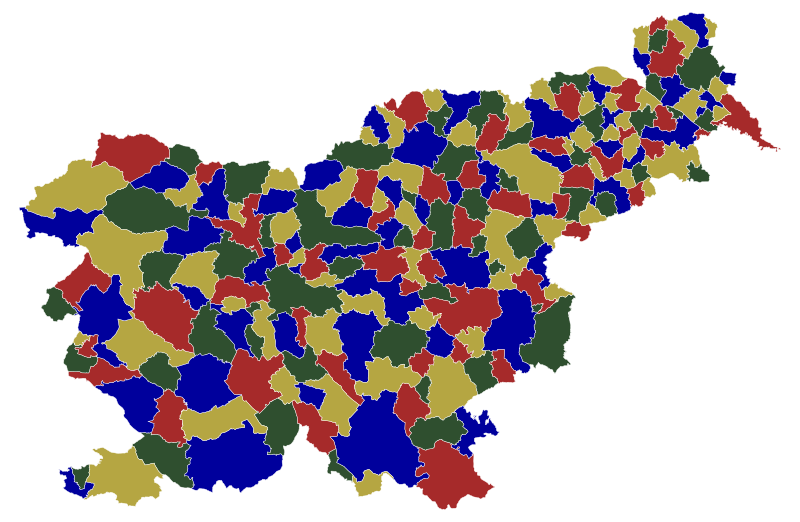
English: Map of the municipalities (občine) of the Republic of Slovenia, as since May 2006 (210 units), colored by 4 colors. Note that there are 210 municipalities, but there are 212 regions on this map, since the Zagorje ob Savi municipality and Gorenja vas - Poljane municipality have exclaves south of the main part. Although with this stricter restriction the 210-vertex graph was non-planar, it was fortunately still 4-colorable. So this is both an example of the 4 color theorem for 212 regions, and valid 4-color map for Slovenian municipalities. |
| Tanggal | |
| Sumber | Source of the public data is GURS (Geodetska uprava Republike Slovenije or Surveying and Mapping Authority of the Republic of Slovenia). Converted from Shapefile to SVG with shp2svg and prepared for Wikipedia, input matrix prepared from SVG adjacency points, then fed to the A. Dharwadker's Vertex Coloring Algorithm which produced text output, which was incorporated back to SVG by romanm (talk). |
| Pembuat | See above. |
| Izin (Menggunakan kembali berkas ini) |
Public domain. See Image:Obcine Slovenija 2006.svg for an explanation. |
| Versi lainnya |
|


Lisensi
| Saya, pemegang hak cipta karya ini, merilis karya ini ke domain umum. Lisensi ini berlaku di seluruh dunia. Di sejumlah negara, tindakan ini tidak memungkinkan secara sah; bila seperti itu: Saya memberikan siapa pun hak untuk menggunakan karya ini untuk tujuan apa pun, tanpa persyaratan apa pun, kecuali yang ditetapkan oleh hukum. |
Riwayat berkas
Klik pada tanggal/waktu untuk melihat berkas ini pada saat tersebut.
| Tanggal/Waktu | Miniatur | Dimensi | Pengguna | Komentar | |
|---|---|---|---|---|---|
| terkini | 18 Juli 2009 21.40 | | 2.613 × 1.705 (2,36 MB) | Romanm | {{Information |Description=Map of the municipalities (občine) of the Republic of Slovenia, as since May 2006 (210 units), color by 4 colors. |Source=Source of [http://www.gu.gov.si/si/delovnapodrocja_gu/podatki_gu/brezplani_podatki/brezplani_podatki_obin |
Penggunaan berkas
Tidak ada halaman yang menggunakan berkas ini.