
Berkas:CEM-44-La-Chine-la-Tartarie-Chinoise-et-le-Thibet-1734-Amur-2572.jpg

Ukuran pratayang ini: 798 × 599 piksel. Resolusi lainnya: 320 × 240 piksel | 639 × 480 piksel | 1.023 × 768 piksel | 1.280 × 962 piksel | 2.492 × 1.872 piksel.
Ukuran asli (2.492 × 1.872 piksel, ukuran berkas: 1,85 MB, tipe MIME: image/jpeg)
| Deskripsi |
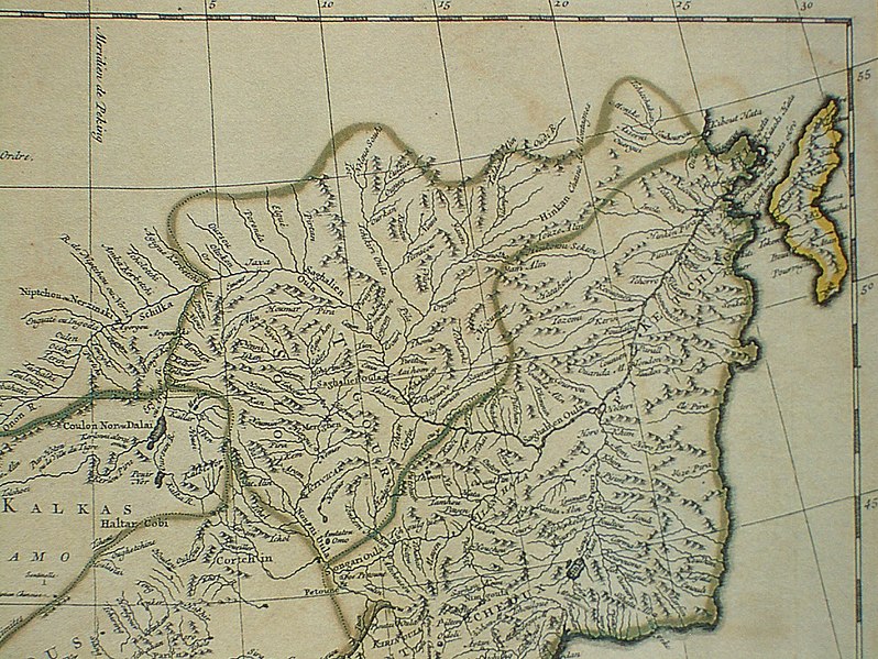
Français : Carte la plus generale et qui comprend la Chine, la Tartarie Chinoise, et le Thibet. Dressee sur les cartes particuliers des RR PP Jesuites, par le Sr. d'Anville..., qui ya joint le pays compris entre Kashgar et la mar Caspienne, tire des geographes et des historiens orientaux
English: A most general map, including China, Chinese Tartary, and Tibet, based on individual maps of the Jesuit fathers. The map gives 1734 as the year, but the modern HKUST publishers say 1737
English: Fragment: Amur River area
"D’Anville’s maps of China were based on a survey of the Chinese empire that was ordered by the emperor in 1708 and carried out by the Chinese, but under the supervision of Jesuit priests resident in China. The detail about the interior of China was far superior to any previous Western map or atlas. D’Anville’s work remained a standard Western source for the geography of China and adjacent regions until well into the 19th century, when it finally was superseded by more accurate maps." — (World Digital Library) |
||||||||||||||||||||
| Tanggal | 1734, according to the map itself (although the modern publishers say 1737) | ||||||||||||||||||||
| Sumber |
English: An antique map from the Special Collection "China in Maps" of the Hong Kong University of Science and Technology Library, reproduced by the HKUST Library in the book "China in European Maps", Hong Kong, 2003. ISBN 962-86403-9-9.
Русский: Старинная карта из специальной коллекции Библиотеки Гонконгского научно-технического университета. Опубликована этой библиотекой в книге "China in European Maps" (Китай на европейских картах), Гонконг, 2003. ISBN 962-86403-9-9, тиражом 1000 экз. См. также каталог выставки, Special Collection "China in Maps".
Plate 44 |
||||||||||||||||||||
| Pembuat |
|
||||||||||||||||||||
| Izin (Menggunakan kembali berkas ini) |
Author died more than 70 years ago - public domain | ||||||||||||||||||||
| Versi lainnya |
Entire map:  |
||||||||||||||||||||


|
This work is in the public domain in its country of origin and other countries and areas where the copyright term is the author's life plus 100 years or fewer. | |
| Berkas ini telah diidentifikasi bebas dari pembatasan menurut hukum hak cipta termasuk semua hak terkait dan relevan. | |
| Annotations | This image is annotated: View the annotations at Commons |
Riwayat berkas
Klik pada tanggal/waktu untuk melihat berkas ini pada saat tersebut.
| Tanggal/Waktu | Miniatur | Dimensi | Pengguna | Komentar | |
|---|---|---|---|---|---|
| terkini | 7 Juni 2010 01.07 | | 2.492 × 1.872 (1,85 MB) | Ras67 | losslessly cropped with Jpegcrop |
| 22 Maret 2009 13.32 |  | 2.560 × 1.920 (2,07 MB) | Vmenkov | {{Information |Description={{fr|Carte la plus generale et qui comprend la Chine, la Tartarie Chinoise, et le Thibet. Dressee sur les cartes particuliers des RR PP Jesuites, par le Sr. d'Anville..., qui ya joint le pays compris entre Kashgar et la mar Casp |
Penggunaan berkas
Halaman berikut menggunakan berkas ini:
Penggunaan berkas global
Wiki lain berikut menggunakan berkas ini:
- Penggunaan pada ast.wikipedia.org
- Penggunaan pada be-tarask.wikipedia.org
- Penggunaan pada be.wikipedia.org
- Penggunaan pada bg.wikipedia.org
- Penggunaan pada cs.wikipedia.org
- Penggunaan pada en.wikipedia.org
- Penggunaan pada eo.wikipedia.org
- Penggunaan pada es.wikipedia.org
- Penggunaan pada et.wikipedia.org
- Penggunaan pada eu.wikipedia.org
- Penggunaan pada fa.wikipedia.org
- Penggunaan pada fr.wikipedia.org
- Penggunaan pada hr.wikipedia.org
- Penggunaan pada ja.wikipedia.org
- Penggunaan pada mn.wikipedia.org
- Penggunaan pada nl.wikipedia.org
- Penggunaan pada nn.wikipedia.org
- Penggunaan pada no.wikipedia.org
- Penggunaan pada pl.wikipedia.org
- Penggunaan pada pt.wikipedia.org
- Penggunaan pada ru.wikipedia.org
Lihat lebih banyak penggunaan global dari berkas ini.