
Berkas:Australia first map.jpg

Ukuran asli (3.604 × 2.696 piksel, ukuran berkas: 3,81 MB, tipe MIME: image/jpeg)
Ringkasan
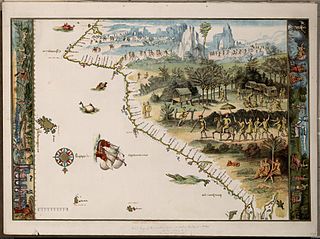
Facsimile of chart from Nicholas Vallard's manuscript sea atlas (1547), showing Jave La Grande's west coast. The facsimile was given the title "The first Map of Australia from Nicholas Vallard's Atlas, 1547" by the English publisher in 1856. The original Vallard chart was produced in Dieppe, France in the 16th century. It is thought by several writers to represent Portuguese charting of the western coast of Australia, however the geographical features (i.e. 'cap' cape, 'Illa' Island, 'illet' islet, 'port' harbour) are actually written in Catalan. This copy is held by the National Library of Australia. [cartographic material] : from the Library of Sir Thomas Phillipps, Bart. at Middle Hill, 1856. Image from the National Library of Australia: http://nla.gov.au/nla.map-rm2393 The original Vallard map is held by the Huntington Library, San Marino, California and can be viewed at http://sunsite3.berkeley.edu/hehweb/HM29.html archive copy at the Wayback Machine
From NLA catalogure information: Scale: Scale indeterminable. Publisher: [Worcestershire : Middle Hill Press, 1856] (Chester : McGahey chromo. lith.) Date: 1856 Material Type: Map Physical Description: 1 map : col. ; 37.6 x 55.4 cm. Notes: Facsimile of chart from Nicholas Vallard's manuscript sea atlas (1547), now held in the Huntington Library, San Marino, California.
Map is in folder with title: Vallard's map of the coast of Greater Java.
Lisensi
|
This work is in the public domain in its country of origin and other countries and areas where the copyright term is the author's life plus 70 years or fewer.
| |
| Berkas ini telah diidentifikasi bebas dari pembatasan menurut hukum hak cipta termasuk semua hak terkait dan relevan. | |
Riwayat berkas
Klik pada tanggal/waktu untuk melihat berkas ini pada saat tersebut.
| Tanggal/Waktu | Miniatur | Dimensi | Pengguna | Komentar | |
|---|---|---|---|---|---|
| terkini | 17 Oktober 2006 00.58 | | 3.604 × 2.696 (3,81 MB) | Gobeirne | |
| 30 November 2005 22.55 |  | 760 × 580 (110 KB) | Matilda | First map of Australia [cartographic material] : from Nicholas Vallard's atlas, 1547, in the Library of Sir Thomas Phillipps, Bart. at Middle Hill, 1856. Image from the National Library of Australia: http://nla.gov.au/nla.map-rm2393 From NLA catalogure i |
Penggunaan berkas
2 halaman berikut menggunakan berkas ini:
Penggunaan berkas global
Wiki lain berikut menggunakan berkas ini:
- Penggunaan pada af.wikipedia.org
- Penggunaan pada en.wikipedia.org
- Penggunaan pada es.wikipedia.org
- Penggunaan pada fr.wikipedia.org
- Penggunaan pada he.wikipedia.org
- Penggunaan pada it.wikipedia.org
- Penggunaan pada ja.wikipedia.org
- Penggunaan pada jv.wikipedia.org
- Penggunaan pada ka.wikipedia.org
- Penggunaan pada mk.wikipedia.org
- Penggunaan pada nl.wikipedia.org
- Penggunaan pada pt.wikipedia.org
- Descoberta da Austrália
- Predefinição:Esboço-históriaau
- Mapas de Dieppe
- Colônia de Nova Gales do Sul
- Ordem da Austrália
- Teoria da descoberta da Austrália pelos portugueses
- Eureka Stockade
- Federação da Austrália
- Austrália Branca
- Colônia da Tasmânia
- Colônia de Queensland
- Federalismo na Austrália
- João Alfonso
- Penggunaan pada ru.wikipedia.org
- Penggunaan pada ru.wikiversity.org
- Penggunaan pada sr.wikipedia.org
- Penggunaan pada tr.wikipedia.org
- Penggunaan pada uk.wikipedia.org
Lihat lebih banyak penggunaan global dari berkas ini.