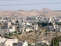
Beit Sahour
Beit Sahour | |
|---|---|
| Transkripsi Arab | |
| • Arab | بيت ساحور |
| • Latin | Beit Sahur (resmi) Bayt Sahoor (tak resmi) |
 Pemandangan Beit Sahour | |
|
Logo resmi Beit Sahour Segel Munisipal Beit Sahour | |
Lokasi Beit Sahour di Palestina | |
| Koordinat: 31°42′N 35°13′E / 31.700°N 35.217°EKoordinat: 31°42′N 35°13′E / 31.700°N 35.217°E | |
| Negara | Negara Palestina |
| Kegubernuran | Bethlehem |
| Pemerintahan | |
| • Jenis | Municipalitas |
| • Kepala Munisipalitas | Jehad Khair [1] |
| Luas | |
| • Total | 6.945 dunams (6,9 km2 or 27 sq mi) |
| Populasi (2007) | |
| • Total | 12.367 |
| • Kepadatan | 0,18/km2 (0,46/sq mi) |
| Arti nama | "Wangsa penyihir"[2] |
| Situs web | Beit Sahour Municipality |
Beit Sahour dari Ibrani בֵּית סָחוּר Bēthsāhūr (Rumah Dagang) (Arab: بيت ساحور dibaca ⓘ) adalah sebuah kota Palestina di timur Bethlehem yang berada di bawah administrasi Otoritas Nasional Palestina. Populasinya berjumlah 12.367 orang,[3] 80% Kristen (sebagian besar Ortodoks Yunani) dan 20% Muslim.[4]
Referensi[sunting | sunting sumber]
- ^ [1] Diarsipkan November 20, 2008, di Wayback Machine.
- ^ Palmer, 1881, p. 286
- ^ 2007 PCBS Census Palestinian Central Bureau of Statistics. p.117.
- ^ History, Economy, and Tourism Diarsipkan 2014-03-20 di Wayback Machine. Beit Sahour Municipality.
Daftar pustaka[sunting | sunting sumber]
- Abel, F.M. (1938). Geographie de la Palestine. 2 Geographie Politique. Les villes. Librairie Lecoffre.
- Barron, J.B., ed. (1923). Palestine: Report and General Abstracts of the Census of 1922. Government of Palestine.
- Burgoyne, Michael Hamilton (1987). Mamluk Jerusalem. ISBN 090503533X.
- Clermont-Ganneau, C.S. (1899). [ARP] Archaeological Researches in Palestine 1873-1874, translated from the French by J. McFarlane. 1. London: Palestine Exploration Fund.
- Conder, C.R.; Kitchener, H.H. (1883). The Survey of Western Palestine: Memoirs of the Topography, Orography, Hydrography, and Archaeology. 3. London: Committee of the Palestine Exploration Fund. 29; 29, 85 (Beit Sahur al-Atiqah)
- Government of Jordan, Department of Statistics (1964). First Census of Population and Housing. Volume I: Final Tables; General Characteristics of the Population (PDF).
- Government of Palestine, Department of Statistics (1945). Village Statistics, April, 1945.
- Guérin, V. (1868). Description Géographique Historique et Archéologique de la Palestine (dalam bahasa French). 1: Judee, pt. 1. Paris: L'Imprimerie Nationale.
- Hadawi, S. (1970). Village Statistics of 1945: A Classification of Land and Area ownership in Palestine. Palestine Liberation Organization Research Centre.
- Hartmann, M. (1883). "Die Ortschaftenliste des Liwa Jerusalem in dem türkischen Staatskalender für Syrien auf das Jahr 1288 der Flucht (1871)". Zeitschrift des Deutschen Palästina-Vereins. 6: 102–149.
- Hütteroth, Wolf-Dieter; Abdulfattah, Kamal (1977). Historical Geography of Palestine, Transjordan and Southern Syria in the Late 16th Century. Erlanger Geographische Arbeiten, Sonderband 5. Erlangen, Germany: Vorstand der Fränkischen Geographischen Gesellschaft. ISBN 3-920405-41-2.
- Kildani, Hanna (2010). Modern Christianity in the Holy Land. AuthorHouse. ISBN 9781449052843.
- Mills, E., ed. (1932). Census of Palestine 1931. Population of Villages, Towns and Administrative Areas. Jerusalem: Government of Palestine.
- Palmer, E.H. (1881). The Survey of Western Palestine: Arabic and English Name Lists Collected During the Survey by Lieutenants Conder and Kitchener, R. E. Transliterated and Explained by E.H. Palmer. Committee of the Palestine Exploration Fund.
- Robinson, E.; Smith, E. (1841). Biblical Researches in Palestine, Mount Sinai and Arabia Petraea: A Journal of Travels in the year 1838. 2. Boston: Crocker & Brewster. (pp. 157, 159, 171)
- Sharon, M. (1999). Corpus Inscriptionum Arabicarum Palaestinae, B-C. 2. BRILL. ISBN 90-04-11083-6.
- Schick, C. (1896). "Zur Einwohnerzahl des Bezirks Jerusalem". Zeitschrift des Deutschen Palästina-Vereins. 19: 120–127.
- Socin, A. (1879). "Alphabetisches Verzeichniss von Ortschaften des Paschalik Jerusalem". Zeitschrift des Deutschen Palästina-Vereins. 2: 135–163.
- Toledano, E. (1984). "The Sanjaq of Jerusalem in the Sixteenth Century: Aspects of Topography and Population". Archivum Ottomanicum. 9: 279–319.
Pranala luar[sunting | sunting sumber]
- Beit Sahour Municipality
- History of Beit Sahour residents Diarsipkan 2016-08-26 di Wayback Machine.
- Beit Sahour City Diarsipkan 2014-12-17 di Wayback Machine.
- Welcome To The City of Bayt Sahur
- Survey of Western Palestine, Map 17: IAA, Wikimedia commons
- Beit Sahour City Profile, Applied Research Institute–Jerusalem (ARIJ)
- The priorities and needs for development in Beit Sahour city based on the community and local authorities’ assessment, ARIJ
- Beit Sahour, A living Heritage di YouTube

