
Berkas:Lake Huron bathymetry map.png
Ukuran asli (936 × 1.024 piksel, ukuran berkas: 1,35 MB, tipe MIME: image/png)
Ringkasan
| Deskripsi |
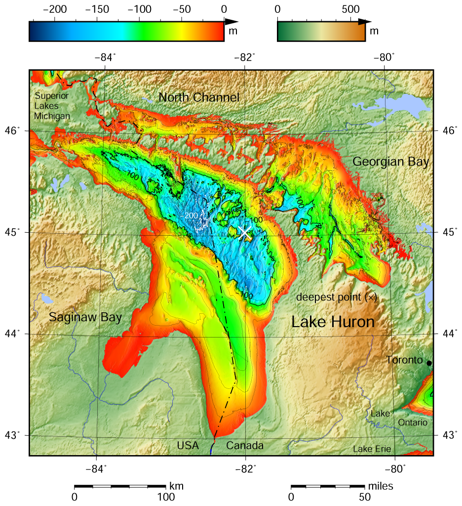
English: Lake Huron bathymetric shaded relief map contoured with interval 25 m (100 m with thicker lines). The deepest point is marked with "×". For land the vertical datum is sea level, for bathymetry low water datum of the lake. The map was created using the Generic Mapping Tools, GMT, version 5.1.1. |
| Tanggal | |
| Sumber |
Own work using: the following Public Domain datasets (grids):
The coordinates of deepest point are taken from the NOAA Great LakesEnvironmental Research Laboratory webpage (www.glerl.noaa.gov/, kml file Google Earth Great Lakes Tour). Gambar ini dibuat menggunakan GMT. |
| Pembuat | Darekk2 using the Great Lakes Bathymetry and GLOBE tiles |
| Versi lainnya |
|

Lisensi
Attribution (in addition to the author of this map):
The NGDC in it's copyright notice says:
As required by 17 U.S.C. 403, third parties producing copyrighted works consisting predominantly of the material produced by U.S. government agencies must provide notice with such work(s) identifying the U.S. Government material incorporated and stating that such material is not subject to copyright protection within the United States. (...)
(for credits see the Source section).
and Great Lakes Bathymetry and GLOBE
(see above and the Source section)
- Anda diizinkan:
- untuk berbagi – untuk menyalin, mendistribusikan dan memindahkan karya ini
- untuk menggubah – untuk mengadaptasi karya ini
- Berdasarkan ketentuan berikut:
- atribusi – Anda harus mencantumkan atribusi yang sesuai, memberikan pranala ke lisensi, dan memberi tahu bila ada perubahan. Anda dapat melakukannya melalui cara yang Anda inginkan, namun tidak menyatakan bahwa pemberi lisensi mendukung Anda atau penggunaan Anda.
- berbagi serupa – Apabila Anda menggubah, mengubah, atau membuat turunan dari materi ini, Anda harus menyebarluaskan kontribusi Anda di bawah lisensi yang sama seperti lisensi pada materi asli.
Riwayat berkas
Klik pada tanggal/waktu untuk melihat berkas ini pada saat tersebut.
| Tanggal/Waktu | Miniatur | Dimensi | Pengguna | Komentar | |
|---|---|---|---|---|---|
| terkini | 10 Mei 2015 12.21 | | 936 × 1.024 (1,35 MB) | Darekk2 | a small island in NE Michigan |
| 8 Mei 2015 18.00 |  | 936 × 1.024 (1,35 MB) | Darekk2 | forgot about few islands in south ... !! | |
| 8 Mei 2015 16.57 |  | 936 × 1.024 (1,35 MB) | Darekk2 | thicker deepest point mark | |
| 8 Mei 2015 15.27 |  | 936 × 1.024 (1,35 MB) | Darekk2 | User created page with UploadWizard |
Penggunaan berkas
Halaman berikut menggunakan berkas ini:
Penggunaan berkas global
Wiki lain berikut menggunakan berkas ini:
- Penggunaan pada ban.wikipedia.org
- Penggunaan pada en.wikipedia.org
- Penggunaan pada kn.wikipedia.org
- Penggunaan pada th.wikipedia.org
- Penggunaan pada vi.wikipedia.org
- Penggunaan pada www.wikidata.org