
Berkas:Europe in 1470.PNG

Ukuran pratayang ini: 553 × 599 piksel. Resolusi lainnya: 221 × 240 piksel | 600 × 650 piksel.
Ukuran asli (600 × 650 piksel, ukuran berkas: 46 KB, tipe MIME: image/png)
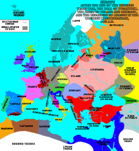
A map of Europe in 1470.
| Karya ini dilepaskan ke domain umum oleh pemiliknya, Lynn H. Nelson. Lisensi ini berlaku di seluruh dunia. Di sejumlah negara, tindakan ini tidak memungkinkan secara sah; bila seperti itu: Lynn H. Nelson memberikan siapa pun hak untuk menggunakan karya ini untuk tujuan apa pun, tanpa persyaratan apa pun, kecuali yang ditetapkan oleh hukum.
|
Source:[1]
_en.png)
.png)
.jpg)
Riwayat berkas
Klik pada tanggal/waktu untuk melihat berkas ini pada saat tersebut.
| Tanggal/Waktu | Miniatur | Dimensi | Pengguna | Komentar | |
|---|---|---|---|---|---|
| terkini | 19 Januari 2024 21.35 | | 600 × 650 (46 KB) | Enyavar | Reverted to version as of 19:31, 8 March 2005 (UTC) --> file had been altered by another user |
| 7 Mei 2008 13.15 |  | 600 × 650 (77 KB) | Fz22~commonswiki | {{Information |Description= |Source= |Date= |Author= |Permission= |other_versions= }} | |
| 8 Maret 2005 19.31 |  | 600 × 650 (46 KB) | Quadell | A map of Europe in 1470.{{PD}}Source:[http://www.ku.edu/kansas/medieval/108/lectures/]Category:Maps of EuropeCategory:Historical mapsCategory:1470 |
Penggunaan berkas
Halaman berikut menggunakan berkas ini:
Penggunaan berkas global
Wiki lain berikut menggunakan berkas ini:
- Penggunaan pada bs.wikipedia.org
- Penggunaan pada ca.wikipedia.org
- Penggunaan pada cv.wikipedia.org
- Penggunaan pada en.wikipedia.org
- Penggunaan pada es.wikipedia.org
- Penggunaan pada et.wikipedia.org
- Penggunaan pada fa.wikipedia.org
- Penggunaan pada fi.wikipedia.org
- Penggunaan pada fr.wikipedia.org
- Penggunaan pada he.wikipedia.org
- Penggunaan pada io.wikipedia.org
- Penggunaan pada it.wikipedia.org
- Penggunaan pada ku.wikipedia.org
- Penggunaan pada mk.wikipedia.org
- Penggunaan pada no.wikipedia.org
- Penggunaan pada scn.wikipedia.org
- Penggunaan pada sh.wikipedia.org
- Penggunaan pada sl.wikipedia.org
- Penggunaan pada th.wikipedia.org