
Berkas:16th century Portuguese Spanish trade routes.png

Ukuran pratayang ini: 800 × 335 piksel. Resolusi lainnya: 320 × 134 piksel | 640 × 268 piksel | 1.024 × 429 piksel | 1.280 × 536 piksel | 2.835 × 1.188 piksel.
Ukuran asli (2.835 × 1.188 piksel, ukuran berkas: 2 MB, tipe MIME: image/png)
| Deskripsi |
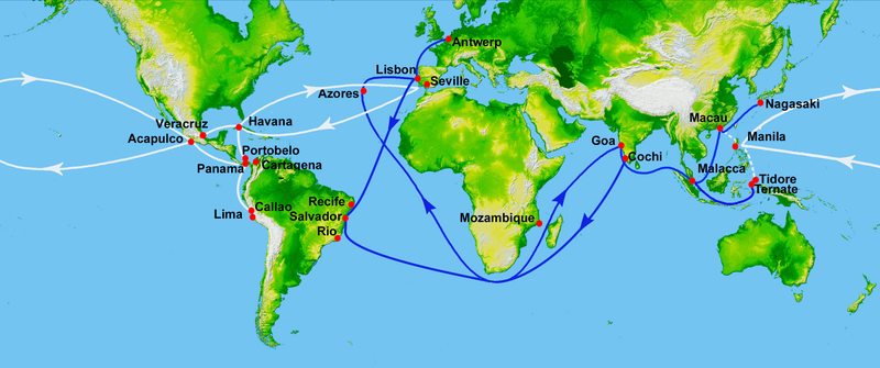
Map showing main Portuguese (blue) and Spanish (white) oceanic trade routes in the 16th century, as a result of the exploration during the Age of Discovery.
|
| Tanggal | (UTC) |
| Sumber | |
| Pembuat |
|
| Ini merupakan gambar hasil penyuntingan yang berarti bahwa gambar tersebut telah diubah secara digital dari versi asli. Perubahan: depiction of 16th century Portuguese and Spanish trade routes. Versi asli dapat dilihat di sini: World Topography.jpg:
|
Berkas ini menggunakan data topografi digital beresolusi tinggi dari Shuttle Radar Topography Mission (SRTM) NASA di JPL-Caltech [1]. Data tersebut berada di domain publik di Amerika Serikat.
|
 | |
Log pengunggahan asli
This image is a derivative work of the following images:
- File:World_Topography.jpg licensed with PD-USGov-NASA-SRTM
- 2009-03-17T12:12:25Z Sk 21600x9049 (17145460 Bytes) {{Information |Description=PIA03395: World in Mercator Projection, Shaded Relief and Colored Height |Source=http://photojournal.jpl.nasa.gov/catalog/PIA03395 |Date=February 2000 |Author=NASA/JPL/NIMA |Permission={{PD-USGov-
Uploaded with derivativeFX
Riwayat berkas
Klik pada tanggal/waktu untuk melihat berkas ini pada saat tersebut.
| Tanggal/Waktu | Miniatur | Dimensi | Pengguna | Komentar | |
|---|---|---|---|---|---|
| terkini | 15 Juli 2023 23.50 | | 2.835 × 1.188 (2 MB) | Hohum | Brighten |
| 17 Februari 2013 20.21 |  | 2.835 × 1.188 (745 KB) | JohnnyMrNinja | remove unused alpha, indexed colors and increased compression (reduced size about 3x) | |
| 16 Januari 2012 23.00 |  | 2.835 × 1.188 (2,45 MB) | Uxbona | restored missing route to Antwerp | |
| 16 Januari 2012 11.00 |  | 2.835 × 1.188 (2,45 MB) | Uxbona | restored missing outbound route | |
| 12 Januari 2012 19.16 |  | 2.835 × 1.188 (2,45 MB) | Uxbona | corrected locations and typo (Seville, Salvador, Manila) | |
| 4 September 2011 00.06 |  | 3.000 × 1.257 (2,66 MB) | Uxbona | (Added Callao after comment, and Antwerp - as those are relevant stopovers. Detailed Brazilian Salvador and Pernambuco stopovers.) | |
| 4 September 2011 00.02 |  | 11.812 × 4.950 (7,84 MB) | Uxbona | Reverted to version as of 23:57, 3 September 2011 | |
| 4 September 2011 00.02 |  | 5.906 × 2.475 (7,52 MB) | Uxbona | (Added Callao after comment, and Antwerp - as those are relevant stopovers. Detailed Brazilian Salvador, Pernambuco and Cochi stopovers.) | |
| 3 September 2011 23.57 |  | 11.812 × 4.950 (7,84 MB) | Uxbona | Added Callao after comment, and Antwerp - as those are relevant stopovers. Detailed Brazilian Salvador and Pernambuco stopovers. | |
| 7 September 2010 08.13 |  | 2.953 × 1.225 (2,4 MB) | Uxbona | add Mozambique stopover |
Penggunaan berkas
Halaman berikut menggunakan berkas ini:
Penggunaan berkas global
Wiki lain berikut menggunakan berkas ini:
- Penggunaan pada ar.wikipedia.org
- Penggunaan pada azb.wikipedia.org
- Penggunaan pada ca.wikipedia.org
- Penggunaan pada de.wikipedia.org
- Penggunaan pada el.wikipedia.org
- Penggunaan pada en.wikipedia.org
- Acapulco
- Colonialism
- Privateer
- New Spain
- Treaty of Tordesillas
- Piracy in the Caribbean
- Conquistador
- Spice trade
- Manila galleon
- Trade route
- Age of Discovery
- Spanish treasure fleet
- Asiento de Negros
- Sea lane
- Filipinos
- Filipino nationalism
- Volta do mar
- List of World Heritage Sites in Mexico
- Marine navigation
- Winds in the Age of Sail
- User:Uxbona
- Iberian ship development, 1400–1600
- Exploration of the Pacific
- User:StAnMc18/sandbox
- Political economy in anthropology
- Global silver trade from the 16th to 19th centuries
- Maritime Silk Road
- Jorge Cabral
- 1557 influenza pandemic
- User:Goatmanatee/Spanish treasure fleet
- User:Goatmanatee/Manila galleon
- Economic history of Latin America
- Penggunaan pada es.wikipedia.org
Lihat lebih banyak penggunaan global dari berkas ini.